Day Four: Lake Sally Ann to Indian Creek Bridge
In late 2003, two key bridges of the Pacific Crest Trail near Glacier Peak were washed out in dramatic downpours. The forest service designated a detour for hikers that took them on poorly maintained trails instead. We knew this was going to be the most challenging section of the hike, but perhaps also the most rewarding. The three past days were "warmups" for the "real" thing. Today would be the first stretch of the detour, and a long one.
We woke up to a clearing sky after a day of clouds. You can't imagine how much this affected our mood. Suddenly we were laughing and joking and smiling. We dried out our damp tents and sleeping bags and packed up, ready for our adventure.
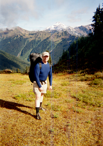
Before we reached the detour we had four miles of pleasant ridge walking, including a place they call "Meandering Meadows" with good reason. Glacier Peak came into view and with the sunshine, she was stunning. Kevin snapped this shot of me with the mountain in the background at left.
After four miles, we met at the Indian Creek junction, where the detour begins. I insisted that we all wait there to make sure everyone followed the detour trail. It was obvious, but I was in my "mother hen" role and wanted to be extra sure that no one missed the spot.
Once we started on the detour, it didn't take more than a few steps for me to realized "we aren't on the PCT anymore." There are regulations for how steep the PCT can be. Because it is for horses as well as hikers, it is an easy grade and well maintained. Now that we were on the Indian Creek trail, conditions worsened. Poor drainage meant there was mud. Poor maintenance meant there were sections of sharp brush we had to walk through. Because it was rarely used, there would be fewer campsites along the way.
To my surprise, the trail stayed away from the creek, so there was not much water available. There are two streams right after the detour leaves the PCT. Bob and Chuck got water there, but I just kept on hiking. The next water was about five miles later. I didn't know that, so I hiked alone in the hot sun, waiting for water that never materialized. My thirst made me angry and tired. I ate lunch with only a little water left to drink, and soon that ran out.
I consulted my maps and I felt Indian Creek could not be far away. Finally, at one large boulder field leftover from a washout, I decided to follow a dry streambed toward the creek. To my surprise, the creek was only about 25 feet away, hidden by some brush. I quenched my thirst and finally relaxed. Soon after, Bob and Chuck turned up and the three of us soaked our feet in the cool waters for a few minutes.
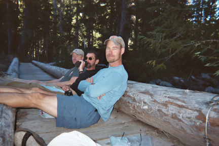
I told the others that here "had" to be a campsite where the trail crosses Indian Creek on a bridge. Kevin liked to walk fast, so we told him to wait for us there. But would there actually be a place to camp, I wondered? After a long day, I was happy to find Kevin and a comfortable campsite in the woods. We took out our clothes to dry and then headed for the creek, where we did some laundry and took a brief bath (that water was COLD). Later that evening we relaxed on the bridge drinking Bob's Irish whiskey.
A report on the Internet said it was possible to ford the White River at this point, saving four miles of hiking. Even better, another report said there were logs that spanned the river, allowing hikers to keep their feet dry. Chuck and I decided to scout out the ford and the log bridges so that, if they worked, we could use them the first thing the next morning.
Chuck and I made our way to the confluence of Indian Creek and White River and saw the logs spanning the river. We made our way across the logs and were satisfied that we could do it with our packs on. Before we left this convenient bridge, we decided to find the trail on the other side of the river, so that there wouldn't have to be route-finding in the morning.
There was a faint boot track from the log bridge that continued in the same direction into the woods. It looked like the logical route, so we took it. For a while we were in deep wood with old growth cedars. It was a unique, Northwest environment. But then we lost any hint of a trail. Suddenly there was nothing but ugly alder brush in what we assumed was the direction of the trail. We couldn't make any headway and decided to turn back to the river.
But where was the river? We had a hard time retracing our steps. Every stand of old growth cedar looked the same. It was a struggle to even find the river, and when we did scamper to the river bank, we didn't know if we were upstream or downstream from the log bridges. Chuck wanted to turn upstream, but I felt they were downstream. After a few moments of debate, Chuck agreed with me to go downstream for a few yards and then, if we couldn't find anything, go upstream.
We couldn't walk directly on the river bank due to the dense brush. We had to hike away from the river, then turn and plunge through the brush to check the next section. We were both frustrated, hot and tired at this point. Then Chuck noticed that Indian Creek was coming into the river on the other side. We knew where we were. The log bridges were downstream and we crashed through the brush to get to them.
So we were back at the far side of the log bridge. We still weren't done, since we hadn't found the trail on this side of the river. We looked at the map carefully and decided to make a right, following the White River downstream for a while. This was the right decision, as we finally found the trail. (Directions on the following page).
We were exhuasted when we finally got back to the campsite, but both Chuck and I were rather proud of our route-finding and that we were going to save four miles of hiking the next day, which would be another rugged detour adventure.