Yellowstone's Bechler River Valley
A Trip Report from 1997
Last updated December 23, 2002
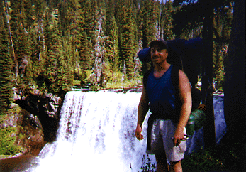
The Bechler River has spectacular waterfalls that you can see from the trails with ease. This is Colonnade Falls, about 14 miles from the trailhead.
After a spectacular backpacking trip through Yellowstone's Lamar River Valley and Pelican Valley in 1991, Bob D., Stu and I had always wanted to go back and try another part of the park. Bob D. in particular had done some solo trips since then, mostly in the same space. He kept talking about trying another region, in particular the very southwest corner where the Bechler River drains into the Bechler Meadows.
In 1997 the talking was over. We made the decision to return to Yellowstone. Even though in 1991 we got our permit the day we started our hike, I decided to be more organized this time. I got USGS topological maps of the area and the backcountry guide. I even made reservations for backcountry campsites in advance, and immediately found out one drawback- -most of the sites along the river were one-day-only sites, when we were looking for a base camp that we could use to explore the area. Our plan was to meet in late morning, hike half a day to a campsite on the river, and then take a full day's hike up river and try to stay in that area for a while. Now we'd have to shift sites almost every day.
This should have immediately sent a signal to us. This was not the wide open spaces of the Lamar Valley region--this would be a narrow river valley with many more people and many fewer options for camping. But we were determined to try something new, so I made the best reservations I could. Stu and I would to drive to the park and meet Bob D., who lives in Colorado, at the trailhead.
So late in August, Stu and I headed out early to drive 840 miles from Seattle to the trailhead some 20 miles east of Ashton, Idaho. Though we made it up to 95 miles per hour on the speed-limit-free Montana interstates, there was no way we could cover all the miles, so we spent the night at a motel in Dillion, Montana, and drove hard the next morning to make our 11 a.m. rendezvous with Bob D.
If you go, you should know that the road between Ashton and the Bechler Ranger Station is not well marked. Get the park service to send you a map. You travel six miles east of Ashton on Hwy. 47 and then, shortly after a sharp curve to the north, you turn right on Green Timber Road. The sign says "Mesa Falls" but it is the way to Yellowstone as well. After another 5.5 miles the pavement ends. The gravel road is in good shape--we were going 35 mph in parts, and you end up in the very southwest corner of the park in a short time.
In fact, we were 10 minutes early for our rendezvous, but when we got there, no Bob D. could be found. Since he planned to camp near the trailhead the night before, this was perplexing. But the rangers soon solved the mystery. "Your buddy came by an hour ago. We gave him the list of campsites and he started hiking."
I was shocked and angry that Bob would just start off on his own, rather than wait for his hiking companions. We did find a cryptic note in a message book in the ranger station that did not really explain this early departure at all. But at least Stu and I knew that he had made it and was on the trail. "When we catch up with him, I am going to really chew that guy out," I told myself.
We got our permit from the ranger, divided up the gear as best we could (somehow I got stuck carrying the tent), and ate a lunch we had packed the day before. By 1 p.m. were we on the trial and headed into adventure.
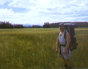
Unlike most of Yellowstone covered with Lodgepole pine, the Bechler River area includes grand--and soggy--meadows. Behind me in the distance are the Grand Teton mountains.
There are two ways to get to the Bechler River valley from the ranger station. The first is to turn left right after the footbridge, following a high trail that eventually reaches the river at Bechler Ford and had a footbridge. The other is to take the trail that goes straight from the bridge, linking up with the river earlier and requiring more fords. Bob D., not having the trail map, took the longer, wetter route, while Stu and I took the shorter, more convenient route to Bechler Ford. (When I found this out later, I said it serves him right.)
Though the first stretch is in forest, eventually you get to the meadows. They are very wide, very brown and very wet. We were in the dry season of late August, and we still found the ground swampy in many sections. At least in this part of the park there were large, bright orange diamond high on posts to mark the paths. And in the distance are the backsides of the Teton Mountains, a scenic bookmark for the region.
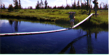
I am crossing over the Bechler River on a narrow suspension bridge.
There were many adventures on the trip. We made it up the river as far as the three forks, including the Ferris Fork. You have to ford the Bechler twice between the forks and the ranger station, and the fords can be pretty hairy early in the season. I'm really mad at the Park Service because the old trail stayed on the south side of the Bechler all the way, but they rerouted the trail so that you have to ford the river twice. My assumption is that they did this to cut down on the number of hikers--since you can't ford the river in the spring when the water is high, and some more timid hikers won't ford it at all! Of course, horse parties can still get through (unfair!). You may have a hard time with the fords--depending on how tall you are and what time of year you are going. We were there in late August and it was still difficult. I'm about 5'8' and at one point the water was above my knees and just about to my crotch. Fortunately the current wasn't very strong.

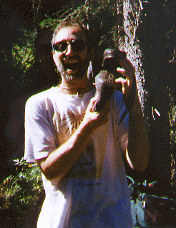
A shot of the traditional burning of the underwear. I was trying to appease the rain gods. It worked.
It rained some days, which is not unusual for that section of the park, which is the wettest and in some ways reminded me of the Pacific Northwest forests. We have a tradition of burning old underwear during the trip, and I did this to see if I could change the weather. Indeed, the sun came out the next day and we had sunshine the rest of the trip.
Another adventure was Stuart's hiking boots--which suddenly came undone. He had just had them resoled and obviously the glue didn't take. However, it turned out because of the marshy fields, Stuart was better off in his Teva sandles than Bob. D. and I were in our boots. By the end of the trip I was hiking in my runnning shoes instead of my Vasque Sundowner boots.
The sole of Stuart's Vasque boots came off in mid-trip. This was just after they had been resoled in Seattle! He really could have been upset, but as you can see, he took it well. Stu made the rest of the hike in his Teva sandals.
After exploring the Bechler River valley, we went cross country to the west side of the park to see Dunanda falls. Suuposedly there are hot springs at the bottom of the falls, but the trail down there looked too dangerous to take. We camped at the designated site near the falls and found it to be the best campsite of the whole trip. The others were confined in the river valley. This one was wide open and had great views. In addition, even the backcountry toilet had great views! It also was much wilder than the Bechler River valley--no other parties within sight. You could tell not many other hikers had used the site this year.
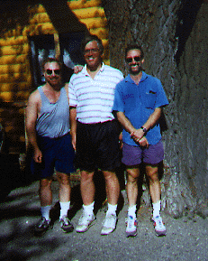
Here are the three hikers after a week in the wilderness. Left to right, me, Bob D. and Stuart.
At the end of the trip, Bob D. followed us to Ashton for a celebration lunch, even though he had to drive back to Colorado. We couldn't possibly drive all the way back to Seattle that day, so we stayed overnight in Butte.
Would I do it again? You bet, though I'd like to have some kind of shuttle serice so that I could do a straight shot from Old Faithful all the way down to the Bechler River Ranger Station. Rather than trying to reserve campsites in advance, I might wait until I get to the park to see which sites the rangers might recommend. There were some great sites we didn't know about beforehand that would have been better than the ones we used. I also would have liked to spend more time bushwacking in the area where the three forks of the Bechler meet. This was gorgeous backcountry and I hear there are some off-trail falls along one of the forks that are quite lovely.
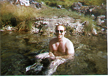
On our way back we found a hot springs in Idaho. I am really enjoying this soak.
One of the best aspects of this part of the country are the many hot springs on and off the highways. We had a book on Idaho hot springs and found a great one. Stuart took some shots of me soaking to my heart's content, which after a long trip in the woods really felt wonderful. In order to preserve the beauty of these spots, I am not going to disclose their locations.
The Idaho hot springs were by a river. Sorry, no directions offered.
Return to Tom Griffin's Hiking Page.
Send E-Mail to Tom Griffin.