Pacific
Crest Trail Trip Report
Hart's
Pass to Canada (almost)
Aug. 27-Sept. 3, 1995
On my usual backpacking trips, the trail starts at a low altitude along a river or creek. It can take one or two days of a long, river walk in the woods before I finally reach the high, open country I love. What's worse, that's one or two days of uphill slogging with 40-45 pounds on my back.My trip along the last leg of the Pacific Crest Trail was anything but usual. Instead of marching up 2,000 feet, the trailhead at Hart's Pass., Washington, was at 6,800 feet--the highest point in the state you can reach by automobile. The moment Bob, Rob and I hit the trail, it was like advancing two days ahead on a regular trip.
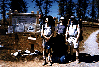
Bob, Rob and Tom (me) at the trailhead at Hart's Pass. Note that the sign says it is 31 miles to the Canadian border.
This stretch of the Pacific Crest Trail is one of the most scenic trails I have ever experienced in 15 years of backpacking. Because most of the trail is above the Cascade treeline, you have clear views of the ocean of mountains. I have never had such unending vistas from the very beginning of a trip like this. We hiked for miles and miles through parklands of grass, heather and wild flowers.
We heard from one PCT through-hiker we met that the trail's grade cannot be more than 12 percent. True or not, the path certainly felt easy compare to some typical "hummers" in the Pasayten Wilderness. We didn't find one example of deadfall on the trail, and the tread was well groomed even through rock fields.
Of course, this means that the trail is extremely popular too. If you want to get away from humanity, the PCT is not the place to be. But Bob, Rob and I found that the views made up for the excess company.
Starting at the trailhead after a four-hour drive from Seattle, we hiked about 5.5 miles the first afternoon to Oregon Basin. About 200 yards east of the trail is a campsite with mediocre water (at least in late summer). At the trailhead we saw many dayhikers, but gradually people disappeared. There was just one camper near us the first night.
The next day we hit the trail, crossing a beautiful ridge called Devil's Backbone and across an avalanche valley. Then came the only wooded section of the trip, hiking to Holman Pass. Once past the pass, the trail opens up gradually to Goat Lakes Basin, about 9 miles from Oregon Basin, where there are campsites for horse parties. The best sites for backpackers are off the main trail, go half a mile to the east for the Goat Lakes. There are no fish in the lakes, but they are a pleasant stop none the less. There are campsites at both upper and lower lakes, both are accessible from Goat Lakes Basin--go high if you are heading for the upper lake, almost to the ridge top.
We had rain the next day and decided to stay at our Goat Lakes site. Bob is claustrophobic in a tent and took two brief hikes in the rain and fog. Rob and I contentedly read our books (Rob read In the Lake of the Woods while I perused This House of Sky) and then took a long "power nap" in the afternoon.
The next morning the weather cleared and remained beautiful the rest of the trip. Our destination was Hopkins Lake, another nine miles or so and the last lake before the border. First we had to traverse Woody Pass. There is a high shortcut that we avoided due to our heavy packs; it just looked too tricky. As you approach Woody Pass on the main trail, there is water about 1/4 miles before the high point and a FABULOUS spring about 1/4 mile after the pass. This is the last water source until Hopkins Lake, so fill up here.
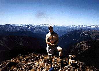
I'm pointing to the top of Three Fools Peak, a 7,950-foot beauty along t he PCT and an easy scramble from the main trail.
We traveled a long, easy traverse along the backside of Three Fools Peak to Lakeview Ridge. Along the ridge there are stunning views of unnamed lakes on the east side of the crest. You are truly walking along the Pacific Crest here, with views in both east and west directions. You can see Mt. Baker, Mt. Shuksan and many other famous North Cascades peaks. We knew we'd have to come back and scale Three Fools Peak for a 360-degree view of the wilderness.
We then reached the high point of this section of the trail at 7,100 feet and started down a series of switchbacks to Hopkins Lake, 6,122 feet. As usual, the beautiful grade of the PCT made the decent easy. To our great fortune, the lake campsites were empty. Bob, an avid fisherman, was worried that the lake was too shallow to hold many fish. While I made a big spaghetti meal, he took out his spinning rod, powerbait and Japanese hooks and on the first cast caught at 15-inch cutthroat trout. A definite high point for him.
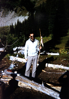
Bob proudly displays his freshly caught trout.
The wildlife is rather fearless in this area. A deer haunted our campsite as soon as we went to bed. One night the doe reached into Rob's back and pulled out his sun hat. She was after the salt residue in the sweat band. The next morning Rob quietly searched for his hat and decided that we had pulled a prank on him. He said nothing for a long time, waiting for us to tease him. But Bob and I never did, because we didn't know the hat was missing. Finally Rob gave up his vow of silence and accused us of thievery. We denied the charges vigorously (it helped that Bob is a trial lawyer), and pinned the blame on the deer. "Let's look around the campsite. Maybe the deer dropped the hat," I said. Sure enough, Bob found it about 50 yards from our tent. Mystery solved, though Rob had to wash out the deer saliva.
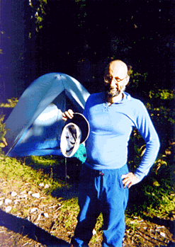
Rob holds his hat the morning after it was a deer's midnight snack.
The weather was perfect and we were content to stay at Hopkins another night, so we dayhiked back up to Lakeview Ridge and then followed the ridge line to Three Fools Peak. There are some brief tricky parts along some rockslides, but otherwise the off-trail hike along the ridge is a cakewalk. Then you scramble up the west side of Three Fools, which can be a real bear after the easy grades of the PCT. Watch out for the scree, but if you like boulder walking, there is a big field near the top that is a kick. At the top you will find a panorama of wilderness. In all directions there is no sign of humanity, save for some patches of clearcut way off in the distance across the border in Canada. For me, this had to the literal and figurative high point of the trip--7,950 feet.
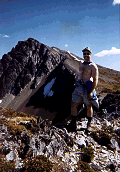
Mr. Macho (me) at the top of Three Fools Peak. There is truly an ocean of mountains in every direction.
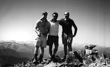
Me, Bob, and Rob at the Three Fool's summit. Note the cairn to the right.
The next day we headed back, foregoing the seven miles from Hopkins Lake to the border. Why didn't we go to the border? Logistically it wouldn't work, since our car was back at Hart's Pass. Secondly, we didn't have the time to go up there on a day hike; we had to start back. Third, Bob had been on this section of the PCT before and said it was a boring forest walk. Fourth, both Bob and I had played along the border in the Pasayten's Horseshoe Basin area, a much better border walk than that along the PCT. So we said farewell to the route to Canada and started back to the Goat Lakes instead.
The trail is just a beautiful on the way back, and because you are looking south, the views seem different as well. We spent a beautiful evening at the Goat Lakes, including a cool swim in the shallow waters, and the next morning headed back toward the trailhead. For our last night out, Bob wanted to do some dry camping at an off-trail campsite along the Devil's Backbone. I wanted to stay lower to take advantage of the only available water. But Rob voted in Bob's favor, so we filled the five-gallon water carrier and strapped it to a pack that Bob wore, sloshing his way to the top of the ridge. I was left carrying the tent . We later figured out that I carried as much weight as Bob did up to the campsite, but his weight moved at every step!

Bob carries 35 pounds of water strapped to the back of a backpack. You can tell it's Bob because he is holding his Cub's hat.
That last night was unforgettable. We finished our stores of bourbon and cognac and watched the stars come out. There were shooting stars as well, high airplanes and even a strange, multicolored something that we fantasized was a UFO. Bob was right to insist we dry camp along this ridge.
The next day we hiked out, passing perhaps 50 people doing day hikes or coming in from Hart's Pass. The people factor is one of the drawbacks to a PCT trip. The day after we left Hopkins Lake, we ran into a party of ten 40- and 50-year-old hikers. They were headed toward the lake with a mule team brining their gear behind them. To have such a party at the lake would have ruined our time there--to say the least. One of the main reasons I go backpacking is to get away from people. If that is one of your goals, the PCT is not going to be your kind of trip.
The Forest Service deserves an extra thanks for such splendid trail building and maintenance. I plan to go back again someday to this incredible world.
To send me e-mail, try griffin@u.washington.edu
Return to Griffin's Hiking Page