The Circulator Computer-Aided Design (C-CAD) Program
1. Program Purpose, Description and Capabilities
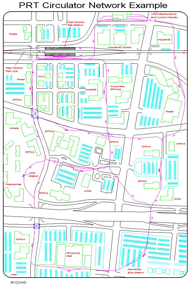
Circulator-CAD is a computer program that can be used to assist the design of network layouts for circulator transit systems for major activity centers (see illustrations for examples). It supports an intuitively-directed interactive graphic design process that enables the transit planner to generate, modify and evaluate several network design layouts quickly and easily. It supports a design process that utilizes an intuitively-directed and iterative "design-test-redesign" method. Starting with a set of design performance objectives and a rough idea of a project budget, the planner can generate and evaluate a series of network designs in which each successive design is "better" than the previous design. This approach enables the integration of the spatial pattern recognition and intuitive capabilities of the planner while making full use of the computational power and memory capabilities of the computer. A typical design process might involve the generation of several designs, each derived from an evaluation of the previous design and each having (usually) better performance measure values than the previous design.
C-CAD consists of three integrated components. One is called OPTIMAL. It is used to determine where the stations (access points) for the transit system should be located so as to minimize the access (walk) times of the people who wish to use the system. The main objective of this part of the design process is to place the stations as close as possible (in walking time) to the people who will be using them. Meeting the needs of the consumer for minimal access times to the system is given top priority.
To achieve this objective, the planner can make several exploratory runs with OPTIMAL, trying different numbers of stations to determine how many stations will be needed to meet an areawide walk-access objective. For example, given an objective of locating the stations so that 85% of the people will be able to walk to them in 5 minutes or less, he/she might try 10, 20 and 30 stations, letting the OPTIMAL search routine find the best locations for them. These results might indicate that his access objective can be reached with less than 30 but more than 20 stations. Subsequent runs might utilize 25 stations and move up or down from there until the areawide walk-access objective is achieved. Further optimization can then be undertaken to fine-tune the design by moving, deleting or adding stations to eliminate any specific weaknesses detected in the computer-generated solution.
Once a set of stations has been found that provide a satisfactory walk-access time statistics, one must identify the routes that will connect the stations into a functional and efficient network layout. While this is a largely intuitive task, C-CAD provides a second program, called NET-ED, to provide the planner with assistance in solving it. This program allows the planner to select the routes visually (on the monitor screen) that will be used to connect the stations. As these decisions are made, they are recorded by the computer and become part of the database used to compute the likely performance of the transit system. When all of the stations have been connected to other stations, the likely performance of the network design can be computed. In making these route selections, it is possible that some station locations will have to be moved, added or deleted. The C-CAD program allows the planner to quickly make such changes and to reevaluate the performance of the design.
Given an initial network design (stations and their connecting routes), a third component program can be used to evaluate the expected performance of the design. Called EMSIMS, it enables the planner to compute a set of performance measures for the design. Fifteen of these performance measures are areawide while others refer specifically to a particular station or route in the design. Other performance information can be obtained by asking specific questions (e.g. what is the total travel time (walking and riding) between origin A and destination B?). A very wide variety of such queries can be answered to help the planner obtain a comprehensive evaluation of the design as well as answering particular question raised by the client. In most cases, the planner will have some performance objectives that he/she is trying to achieve and these results can help determine when a satisfactory design has been found.
Some of the performance measures are numerical, others are spatially defined and can be understood best by viewing them in map form. C-CAD is capable of generating a wide variety of maps, each of which displays a particular component of the performance of the system. For example, one map might show the locations of all persons who have to walk more than 5 minutes to reach a transit station. Another might show the service areas of all of the stations and the longest walk trip in each service area.
Typically, the planner will view these maps, identify strengths and weaknesses of the current design and select one or more physical design modifications that he/she thinks will improve its performance. Possible design modifications include moving, deleting or adding stations and modifying the route layout by moving, adding or deleting segments of the routes that connect the stations. NET-ED can be used to make these design changes and the modified database can be transferred directly into the EMSIMS program so that its new performance values can be evaluated immediately. This "redesign-reevaluate" process can be repeated until satisfactory results are obtained or until it is clear that the desired results cannot be obtained. Starting from a "good" design, it is normally possible to find an "excellent" design with only a few such iterations.
2. Data Requirements
There are five data files that must be prepared before any of the C-CAD programs can be run. Together, these five files describe the two main components of the database -- the network and the spatially-defined demand for circulator system service. The network database consists of three files: a node file, a link file and a delay file. The node file provides the x and y coordinates of all locations of interest in the study area. The link file provides information about the physical distance, assigned speed and type (street or walking) of paths that are used by autos or pedestrians in the study area. The delay file provides information about the delays that autos and people encounter when trying to get from one node to another, the most common example being waiting for a green light at an intersection.
The demand file describes the numbers and locations of the people who are likely patrons of the transit system during a particular time interval. A station candidate file describes all sites (nodes) that have been judged to be feasible and desirable locations for a transit station. Two other files are optional. A geographic features file identifies particular geographic entities (e.g. lakes, particular buildings, etc.) and a stations file describes those candidate locations that are to be used as the starting set for an automated search performed by the OPTIMAL station location program. Note that C-CAD is technology-independent and can deal with a wide range of transit vehicle and guideway types.
3. Hardware/Software Requirements
C-CAD can be operated on IBM and compatible microcomputers equipped with PC-DOS or MS-DOS, version 2.0 or higher. A monitor that supports EGA or VGA color graphics is needed and a color printer is very useful, but not required. In general, the hardware/software required is available almost everywhere today. In order to obtain hardcopies of the many graphic displays available, one needs a CAD program capable of reading files in the DXF (drawing exchange) format. If a CAD program is not available, these files can be saved to disk and taken to another location where a CAD program is available for plotting the graphics. C-CAD was originally designed for classroom use and is very robust and easy to learn and operate.
4. Supporting Software
Two other programs are also available that can be used to support a C-CAD design process. One is called EVALUATOR and it allows the planner to quickly and easily conduct a multicriteria evaluation of alternative designs. It can handle up to 30 different designs, using up to 30 different criteria and up to thirty different judges. It is particularly useful when dealing with competing designs that are described by multiple, often conflicting, criteria. A second program is called DXF-GEN and it can be used to extract a C-CAD database from an CAD drawing. In some cases, it is useful to sketch out a network design, using intuitive methods, in the initial stage of the design process. If this is done with a CAD program (e.g. AutoCAD), this program can be used to extract a network (nodes and links) database that is suitable for a C-CAD analysis with no modifications.
5. Examples of Networks Designed Using the C-CAD Software
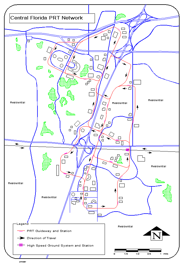
The C-CAD program has been used most recently in the SeaTac PRT study which was completed in August of 1997 in the Seattle, Washington area. A second example is a PRT circulator system that connects a rail station, a bus freeway flyer stop and several office/residential buildings. A third example is a PRT circulator system for a very dispersed office/residential area typical of central Florida and other recently developed areas (e.g. Texas, Colorado, Arizona, California, Oregon, Washington) that also includes a high speed rail station.
6. Program Availability
Persons interested in using these programs should contact Jerry Schneider, Professor Emeritus, Departments of Civil Engineering and Urban Planning, current residing in Portland, Oregon; Ph: 503-353-2709; E-mail: jbs@peak.org .. A paper that describes an application of C-CAD is also available on the Web.
Last modified: July 11, 2012