Day Three: The Ridge and the Clouds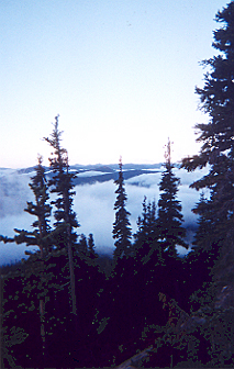
This would be the toughest day of the trip. We would be crossing the infamous ridge walk between Packwood Glacier and Elk Pass, if the weather was good. I knew if the weather was bad that we'd have to wait. At daybreak there was frost on the tent and clouds below us in the valley, but gorgeous blue skies above. I had to take several shots of the low clouds--though none of them came out that well. Tim wanted a big meal so I made eggs from a mix and hash browns. We broke camp with the tent and groundcover still slightly damp. Well, I'll dry them at tonight's camp, I thought.
We were at about 6,000 feet and had to go up to 7,200. The approach to Packwood Glacier and the ridge was mostly above the treeline in fabulous alpine meadows with picturebook vistas of Mt. Adams. Really, how much could anyone complain about the hike up to the glacier? We passed the ruins of a shelter built in memory of someone who had died on the high trail and met a few dayhikers who had been up to the glacier. They said the trail was "socked in" after the glacier, but I didn't pay too much attention to their weather report--my mistake.
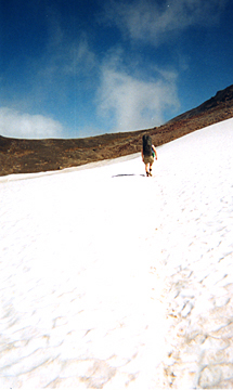 Crossing the flat part of Packwood Glacier.
Late in the morning we made it to Packwood Glacier. The through hikers at White Pass told me the first stretch was no problem, but that the other stretch of about 35 feet of snow could be difficult. "Just use your hiking poles or a stick," one of them said.
They were right about the walk across the first stretch--it was pretty flat and easy. After that snow walk, the trail came to a junction. To the left the trail led to two flat rocks stuck horizontally in the ground--an obvious cairn, I thought. To the right seemed to be the trail to the top of Old Snowy Mountain. I couldn't tell for sure, as the rest of that trail was lost in fog.
So we turned left and went to the cairn, where Tim took my 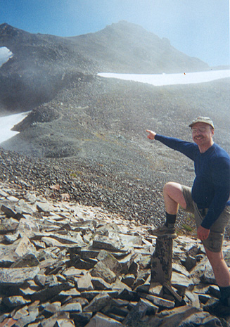 picture pointing back at the trail. Then we started along the ridge
line, but the trail seemed rather difficult. Suddenly we were doing rock
scrambles. Was this the Pacific Crest Trail, I wondered? We hiked on but
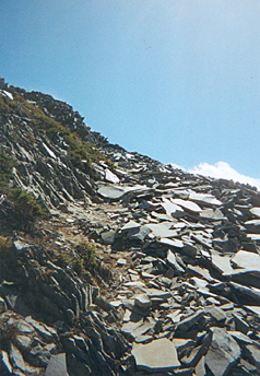
the trail got worse and worse. I stopped and took a picture of what I had
just traveled over-it was that rough. After about half an hour, the boot
track gave out. In the distance we could see a lake--Goat Lake--but it shouldn't
be there if we were on the PCT. We tried to consult the map, but the foggy
landscape didn't help. Tim and I split up and looked for a sign of a trail.
I finally found one far below the ridge line that led to the lake, but we
didn't want to go in that direction.
picture pointing back at the trail. Then we started along the ridge
line, but the trail seemed rather difficult. Suddenly we were doing rock
scrambles. Was this the Pacific Crest Trail, I wondered? We hiked on but
the trail got worse and worse. I stopped and took a picture of what I had
just traveled over-it was that rough. After about half an hour, the boot
track gave out. In the distance we could see a lake--Goat Lake--but it shouldn't
be there if we were on the PCT. We tried to consult the map, but the foggy
landscape didn't help. Tim and I split up and looked for a sign of a trail.
I finally found one far below the ridge line that led to the lake, but we
didn't want to go in that direction.
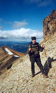
At right: Tom points to the junction and the flat part of Packwood Glacier. Below: The boot track.
 Tim went looking along the ridge and I went back to where
we had left our packs to eat lunch. As I ate, the fog lifted from the next
ridge to the east. I looked at it closely. Could that be where our trail
was? I even thought I saw a trail on the other side. When Tim came back,
he felt that this idea was probably right.
Tim went looking along the ridge and I went back to where
we had left our packs to eat lunch. As I ate, the fog lifted from the next
ridge to the east. I looked at it closely. Could that be where our trail
was? I even thought I saw a trail on the other side. When Tim came back,
he felt that this idea was probably right.
So back we went over the boot track, scrambling over scree and large boulders, getting tired before we finally met up with the PCT again. As we got closer, we could see it clearly. What a sight--cliff-edge walks followed by sections atop the ridge line. It was a relief to get back to the junction and take the right turn, but our adventure was just beginning. First we has a half-mile of walking in scree along the side of a long, steep bowl. One bad step, and you could tumbled down a rock slide with nothing to stop you for 1,000 feet.
Then came the "35 feet" of snow and ice that the through hikers had warned us about. Fortunately, it was early afternoon and the snow had a chance to warm up in the sunshine, now that the fog had lifted. Tim went first since he had hiking poles and boots. I followed in his footsteps, firmly planting my right foot into the snow with each step, and trying not to look down. It was the one spot where my New Balance 805s did not function as well as a regular boot would have.
 Getting off that snowfield was such a relief, but next
was three miles of some of the most difficult trail I have ever hiked. We
went up and down with the crest line, occasionally skirting a sharp point
by going around on the edge of a cliff. With the trail so narrow, one wrong
step could send you plunging down the side of the mountain. It didn't help
to have a powerful wind of 20-25 mph trying to blow you over! Out came the
rain jacket to block the rushing, cold blasts. I even had to put up the
hood to keep my baseball hat from flying off my head. Tim forged on ahead
wearing a sweater, and despite the scenery, both of us just wanted to get
out of there as quickly as we could. I just kept thinking about how mountaineers
must feel like this on some of their approaches. Tim took a snapshot of
me by an old sign, and I took one of him with the trail and Elk Pass in
the distance.
Getting off that snowfield was such a relief, but next
was three miles of some of the most difficult trail I have ever hiked. We
went up and down with the crest line, occasionally skirting a sharp point
by going around on the edge of a cliff. With the trail so narrow, one wrong
step could send you plunging down the side of the mountain. It didn't help
to have a powerful wind of 20-25 mph trying to blow you over! Out came the
rain jacket to block the rushing, cold blasts. I even had to put up the
hood to keep my baseball hat from flying off my head. Tim forged on ahead
wearing a sweater, and despite the scenery, both of us just wanted to get
out of there as quickly as we could. I just kept thinking about how mountaineers
must feel like this on some of their approaches. Tim took a snapshot of
me by an old sign, and I took one of him with the trail and Elk Pass in
the distance.
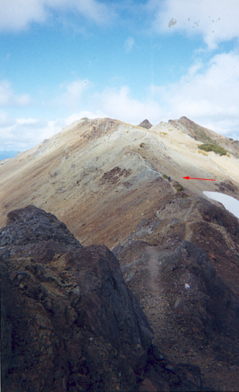
Along the crest: The red arrow points to Tim in the distance.
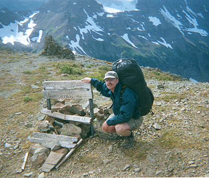
Tom poses by the ruins of an old sign, warning horse parties there is no place to turn around ahead. Note how the ground just seems to drop off into space only a few paces away. |
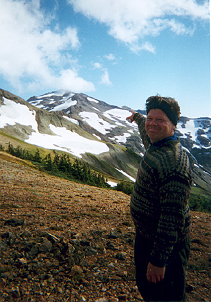
Tim poses with Elk Pass--the end of this crest walk--in the distance on the left. |
I'm not sure how many people have died along this section. Manning and Spring mention two deaths from hypothermia, and there is the trail shelter memorial for another death. I am surprised that the Forest Service lets anyone through here--and somewhat surprised that there aren't more deaths or injuries. I can't understand how they can get horses through this section. I certainly would never recommend hiking this stretch in the rain, fog or snow. But if the weather is fine, it is an extraordinary sight.
 Finally we reached Elk Pass, the end of the ridge walk,
where we took a break and some more pictures. Tim pointed back at where
we came from while I snapped a shot. Then we started down, down, down the
side of a steep valley. We were tired and it wasn't' long before I slipped
on some wet gravel and fell right on my butt. Two seconds later, Tim also
slid and fell. I though he might be making fun of me by purposely falling,
but no, it was a real fall and even worse, he had twisted his ankle. We
needed to get to a campsite quickly. Fortunately there was a site just a
few hundred yards away.
Finally we reached Elk Pass, the end of the ridge walk,
where we took a break and some more pictures. Tim pointed back at where
we came from while I snapped a shot. Then we started down, down, down the
side of a steep valley. We were tired and it wasn't' long before I slipped
on some wet gravel and fell right on my butt. Two seconds later, Tim also
slid and fell. I though he might be making fun of me by purposely falling,
but no, it was a real fall and even worse, he had twisted his ankle. We
needed to get to a campsite quickly. Fortunately there was a site just a
few hundred yards away.
Left: Tim points to the beginning of the three-mile walk along the ridge from its end point: Elk Pass.
With Tim out of commission, it was my job to do everything. I had to fetch things for Tim out of his pack, try to dry off the tent, hunt up firewood, cook dinner, set up the tent and try to keep myself warm as night came and the temperature dropped. Somehow I was able to keep everything under control--even making delicious quesdillas with refried beans and cheddar cheese. Some deer came out to graze on the hillside above us. There was plenty of clean water coming right off a hillside snowfield. The views were marvelous--so we had a great site.