You can scroll down to view the pics, or to the title "Toklat River" to just get the actual backpacking report. I tried to fit the experience in as short a TR as possible, so you probably can tell how incredible a place Denali is by seeing how utterly I failed. Enjoy!
Two weeks in Denali, does it get any better than that? Well I will have to wait a while before I think I'll find something to top this trip. I flew out to Anchorage on Friday the 2nd. Originally my flight was supposed to arrive in Anchorage at 6pm, but it got moved back to 8pm. So I didn't have as much time as I wanted to roam around.
Anchorage
Landed in Anchorage Friday evening and headed out to the Int'l Hostel where I would be staying the night. What irritated me initially about this trip was everyone I encountered always asked me if I was in the Army. There's nothing more bothersome than being mistaken for an Army guy, especially if you used to BE in the Army. I had shaved my head and brought my old Army duffle so I wasn't helping the cause, but still. On the bus ride to the Hostel, I had to hear this guy's story about how he was a Ranger in the Special Forces. After a couple of questions I realized he was completely bullshitting me, but I didn't have the heart to tell him that he was full of it, so I endured the 30 minute bus ride hearing about all his ‘adventures'.
I got a chance to talk to a guy at the Hostel who had just summitted Mt. McKinley. He had been hiking and climbing for a good 2-3 months straight, just living in the backcountry and assorted Hostels, and he shared his ambitious plans to skirt the Alaskan Range. He didn't know if it was doable, but he was ready to find out. He looked emaciated, and he confessed he lost 25 lbs on the McKinley climb because he just didn't feel like eating. I remember reading somewhere loss of appetite is one of the effects of altitude sickness.
I try not to be too judgemental when going to new places, and I know it takes more than a short evening to get a ‘feel' for a city, BUT Anchorage was pretty underwhelming. The city just didn't seem to have a personality. Sure you had some tall Conoco buildings, a few gift shops, many hotels, plenty of annoying seagulls, and some lively bars (where most of the city seemed to be at the time), but that was about it. It was nice to see some Native Americans roaming around among the populace, though a good portion of them were homeless and living on the street.
I tried to get a good night's sleep, but it was difficult because it was midnight and the Sun was still out. My sense of time was totally thrown off and finally I had to just cover my face with one of my shirts to fall asleep.
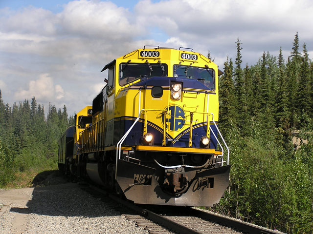
The next morning I boarded the Alaskan Railroad Train. It was a nice ride into Denali. I spent most of my time in the ‘Dining Cart' eating Reindeer Sausage and Eggs, and just reading and writing. There aren't many roads in Alaska and it was interested viewing the landscape go by me. When the train passed over a clear stream I could literally eyeball packs of salmon and other assorted fish hanging out in the water. It looked like you could just grab them out of the creek.
It was interested passing all these homesteader houses, just people that live out in the woods without too much civilization about. I wondered what kind of lives they lived all the way out here, for the most part self-sufficient and on their own. Every house we passed the people always stopped and waved at the train. I assumed they didn't get too much traffic coming through.
Denali Visitors Center
We arrived into the train depot in Denali to a small army of tour buses. 90% of the train occupants got off the trains and headed directly for the buses as part of some $3000+ tour undoubtedly. I waited for the Denali shuttle and headed out to the Visitors Center to reserve a campground and hopefully book my hiking itinerary for the park.
Well between determining where to stow my food supplies while I was hiking, finding open ‘units' that were available to camp, and coordinating each leg of my trip with the bus schedule it took me almost 3 days to get everything situated. I came there reasonably prepared, with an idea of what ‘unit's I wanted to camp in, but entire process was a little more time consuming than I had hoped for.
One thing about Denali, there wasn't as many backcountry hikers as I was led to believe reading books about the place. Sure there were a few here and there wanting to camp, but the VAST MAJORITY of visitors were older tourists (often foreign) who were planning on not spending a night out of their RV's and in the wild. Needless to say, they were everywhere, and were highly annoying, not understanding the first thing about ‘leave no trace' and hiking etiquette.
Thank God they had a separate ‘Camper Bus' which serviced campers only. I didn't want to have to endure 6 hours riding through the park with the tourist crowd.
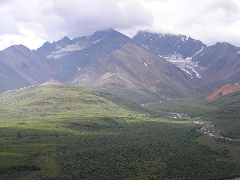
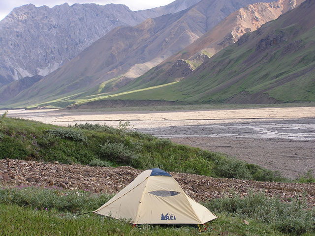
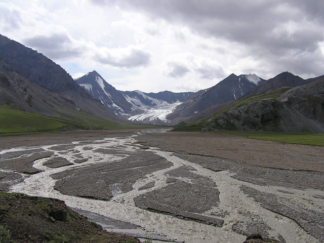
Toklat River
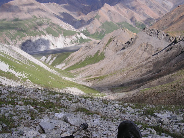
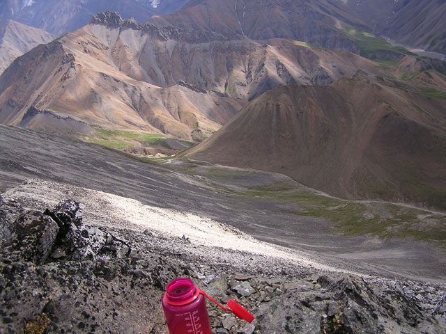
My first stop in Denali included a 3 night stay at the East Branch of the Toklat River. It was a popular area and I was lucky enough to get in. Denali has a strict ‘quota system' which means the park is separated into units and they only allow a certain amount of people in any unit at any given time. So I had roughly 14,000+ acres to share with 5 other people! Increases the chances I don't have to see anyone's ugly mug my entire time there.
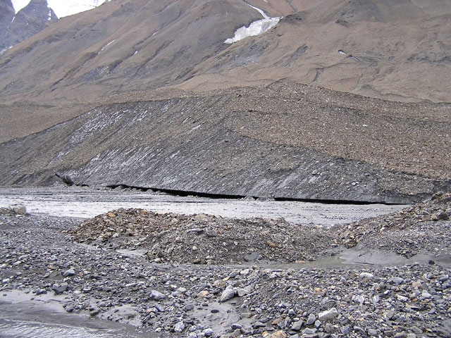
A portion of the Toklat River has been closed to campers because a pack of wolves was roaming the valley and they wanted to minimize human encounters. What this mean to me? Well a pain in the ass for starters! I had to hike 3 miles around the closure zone in order to drop into the valley and begin my trek. All in all I was glad though to be finally in the backcountry, and done with the red tape at the Visitors Center.
I dropped down into the Toklat Valley and proceeded to hug the River. I knew at some point I was going to have to cross over the river going South into the valley, but it was very deep in places, so I continued on looking for the most braided (and shallowest) portion. I couldn't find a decent section to cross one mile into the trek, and I was being squeezed by a bluff to the north. I was hoping that I would be able to find a narrow path along base of the bluff to make my way across, but I eventually had to drop into a deep part of the river. I got out my waterproof socks, sandals, and rain pants.
The sun was really heating things up, so I waded into the river braid up to my belly, trying to stay close to the bluffside. It was cold, but the combination of gear really kept me from cramping up, which I usually do in ice cold waters. It was difficult to maneuver in swift running water with 45 lbs of gear on my back. I was able to edge my way to the other side and hiked further into the shrubby interior.
I took a break to change back into my boots, when I realized that my gaiters had somehow got dislodged from the outside of my pack and probably floated down the river somewhere. Damn!
The day was nice, so I wasn't going to let any little setbacks mar my enjoyment. The terrain was really wide open so I could still see the main road from a few miles out. We are required to camp ‘out of site' from the road, but I will have to find a good spot to keep from sight distance from the road.
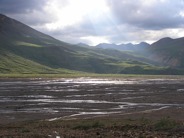
I hiked through a nice lowland area with a clear stream. It takes some planning in Denali to make sure you are hiking to spots with clear streams, as most rivers and streams are filled with glacial silt and are thus a little too muddy for water filtration.
As I was perusing a spot to possibly set up camp I ran into a group of 6 people, including some noisy kids. They were obviously NOT in their proper section, since the Toklat unit only allows 5 people total. I chatted with one of the guys setting up his tent, and I guess they had gotten caught up in the rain the previous night and had wandered down from their proper unit in the highlands down to the Toklat. No biggie, so I decided that I was going to just ‘go deep' into the valley to get away from those intrusive humans. Children were the last nonnative species of animal I wanted to encounter out here.
I tried to get some good distance into the valley, and I found a great bluff with a nice green meadow sitting over the top of it. It had nice views of the entire valley, allowing me to see anything that would come my way. I consulted my topo map, which showed a clear stream close by. It was actually sitting 20 ft to the side of the bluff. What an excellent spot!
I set up my tent and had a nice dinner. The ground was really spongy, which was a welcome change from the feet-eating river beds below. When the sun came low on the horizon it cast it's rays like a spotlight on various areas of the valley. I just sat with camera in hand marveling at the beauty of the area, and where I was. It was like a nature's show with an audience of one. The green hills leading up to the mountains across the valley from me were spectacular in the sunlight. I sat there for hours just staring. So much to take in at once.
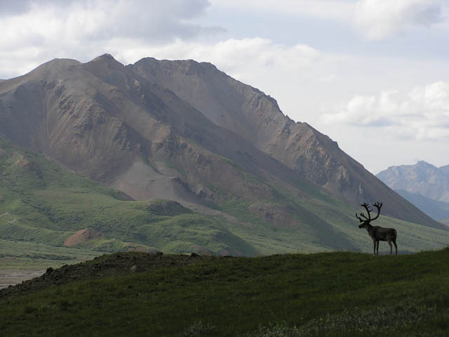
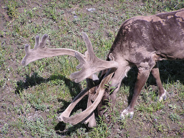
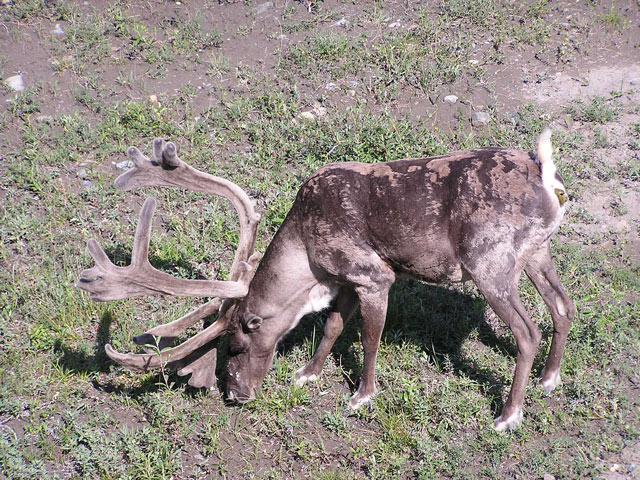
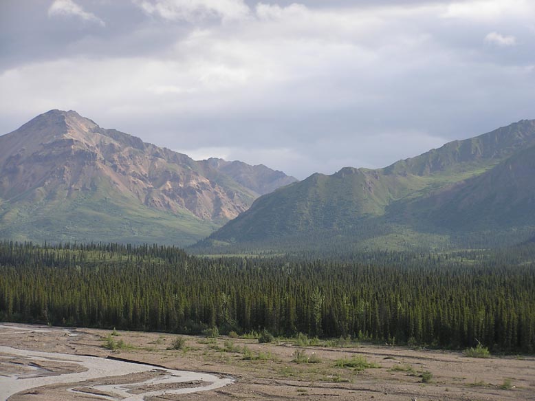
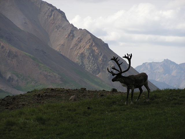
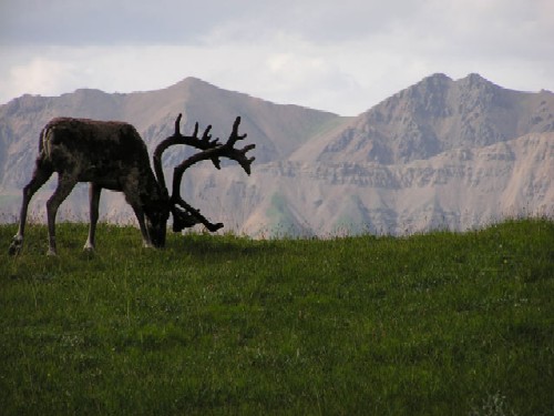
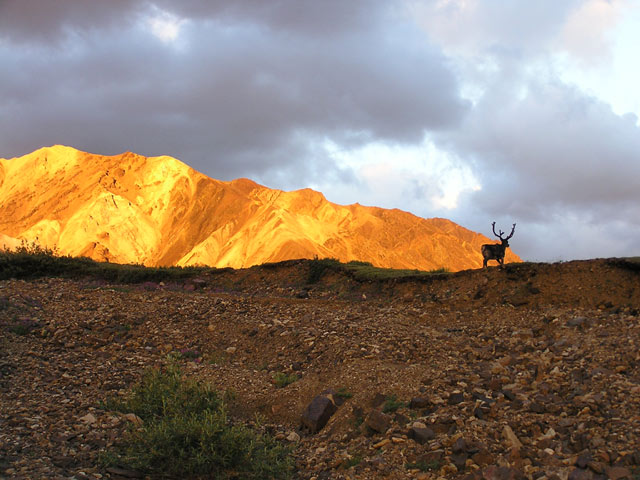
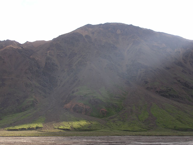
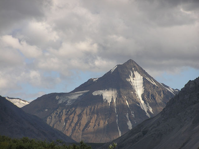
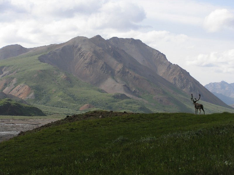
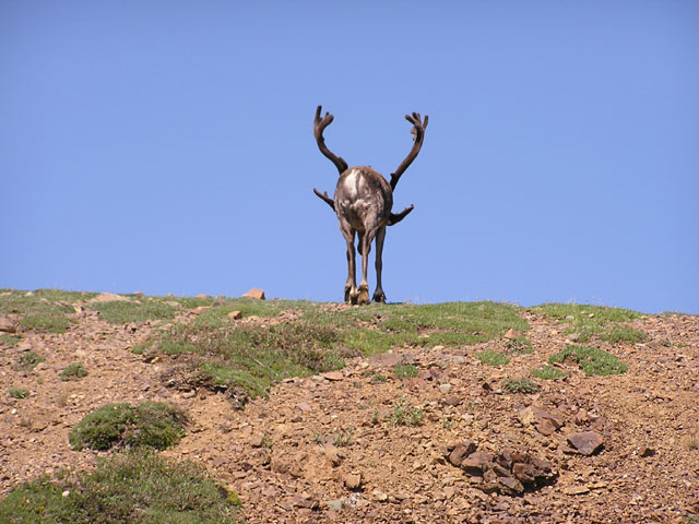
Later that night at about midnight I woke up to relieve myself and was surprised to see a large caribou with an impressive rack of antlers casually gnawing on a bush upstream about 100 ft from me. He saw me with some shock as well. I tried to appear as non-threatening as possible as I walked parallel to where he was up on the slope above me. He couldn't take his eyes off of me, but continued. Then I got too close, so he decided to move on. The Sun broke through the clouds right as the Caribou crested the meadowed slope to the side of me. The rays cast light in a bold array of colors on the mountains behind the animal. These mountains were known for their dramatic light, as they are composed of a variety of colored rocks. They reflected the light and cast a bright orange shade. I once again took a seat and just watched the mountains from my position.
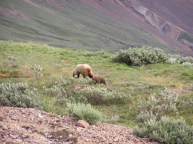
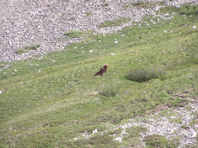
In the morning I felt all the aches and pains as I scrambled out of my sleeping bag to put my boots on. As I tried to need out the soreness I caught something brown and fast moving on my periphery. It was a small bear, a cub, sprinting across the stream near my tent!! I wasn't sure what to do. This little guy, or girl, was moving quickly toward something, and all I could think of was ‘where's momma?' Across the stream, the mother Grizzly lumbered into view. She had a gorgeous blonde coat of hair and she was so close I could actually make out the facial features. She didn't see me at first. The cub playfully jogged around mom, and dropped down near the stream. I was afraid that the little guy might accidently get too close then I'll be momma's next meal. So I stood up calmly. Momma bear squinted her eyes in my direction in recognition. I wanted her to know I was there, but I wasn't about to start yelling and waving my arms. Thank God I had my camera with me all this time!
They obviously were coming down from higher up in the slope to chow down on some soapberries which littered this meadow. They stayed on the other side of the stream, expertly stripping the bushes of fruit. The Mother came into view, as if she was going to come over near my tent, but then went the other direction with the cub, and soon they were no longer visible. I waited an hour or so before cooking anything.
After breakfast, I had the entire day to myself to day hike further into the valley. I wanted to hike to the glaciers that fed the Toklat River. The river actually branched into two valleys, one would require me to cross and recross the river to get to. The other I might be able to bypass crossing by staying up high on the ridge on my side of the valley. So I chose the latter route.
I was able to find an old game trail sitting steeply on the side of the ridge up over the main branch of the river. It was definitely for the sheep, narrow and sketchy in many spots. I was fine till I got to a precarious section of the trail along a loose, rocky slope where it was obvious the trail had washed out. The trail had just disappeared, though I could see the other end of it about 30 ft over the washout. I looked upslope to see if there was a possibility of getting up and around to the other side. It didn't look very good, and this wasn't the type of terrain to go screwing around, there wasn't anything downslope to slow me down if I fell. I would slide straight off a small bluff into the deep portion of the river.
If I went back and dropped down to the valley I knew it was unlikely that I would be able to ford across the river, it was just too deep and fast. I didn't have anyone to call help if I slipped. I could tell there were a couple of footsteps in the washout section where it looked like some of the sheep may have gotten across. I figured I outweighed the heaviest dall sheep by a good 80 lbs, so it was a gamble to see if the loose rocks would stay put under my weight. I figured I would take it slow, make sure that the rocks would hold me and pace myself across. It didn't help that the first foothold required me to stretch my body just to get to it. I got in the middle of the slope, realized that every foothold and handhold was on rocks that shuffled down at the tiniest bit of movement, took a long breathe in and out. I decided looking down wasn't helping my confidence, so I centered on where I needed to go and just advanced. Finally I got to the trail on the other side. Pheww!! Now how am I going to get back across that washout?
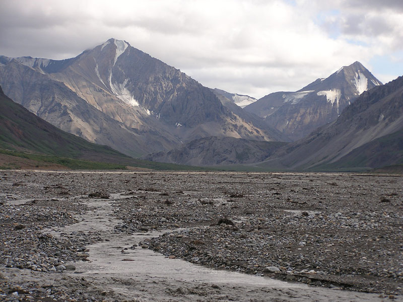
The route slowly descended back down to the valley and the river snaked away from the ridge, so I was able to drop down and walk on river beds the rest of the way. There were some gorgeous dropping waterfalls in the mountains along the way. I saw a shining glint of light high up on a ridge and fought the urge to scramble up and take a closer look.
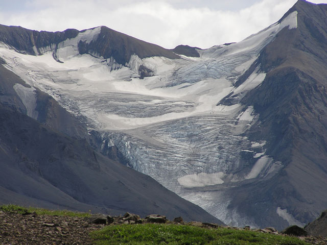
Enormous hanging glaciers steadily came into view and I was snapping away with my camera like Ansel Adams on steroids. It was like finding some gold at the end of the rainbow. I was so glad I kept going, none of these glaciers were visible from the main valley where my tent was, and I didn't expect to see all of this here.
I got really close to a few Dall Sheep, but I was in the midst of trying to ford waist deep water and by the time I got across the stream, if you can call it that, the Sheep had moved to higher ground. I am sure my yelling obscenities at having tripped on a wet rock gave them all the warning they needed to take off.
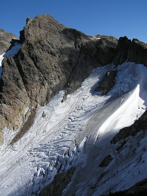
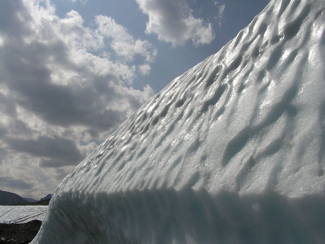
Before I knew it I was ON a glacier, which I didn't realize due to all the rock and rubble that sits on it. I saw that the river was fed at the base of an enormous fingerlike glacier projecting itself into the valley. The exposed portion of the glacier was still another mile ahead and it didn't look like there was a safe route to get there. The main river was fed by three rivers that came spewing out of three natural ice caves situation below the glacier. The portion I was standing on had a very large ice cave underneath where the main body of water ran through.
I scrambled over a portion where I was situation directly above the outlet to the three ice caves and realized I could go no further. You get a good idea on how a glacier moves all the debris down a valley just by hanging out here for a while. I spied exposed sections of glacier and the debris periodically slid down the sides in huge chunks.
You could hear the sound of avalanches revertebrate off the sides of the mountain periodically. I made my way back down the glacier and headed back to the campsite, still nervous about making it across the washout. I was relieved to get back across safely.
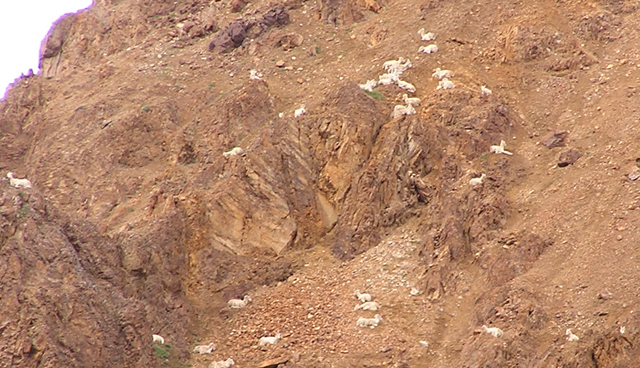
I spotted a group of Dall Sheep up on a ridge on the way back. It's impressive how high they can get up on these ridges, and they go straight up if you watch them. Then they park themselves on any old steep ledge, mostly on the ones that have a little vegetation.
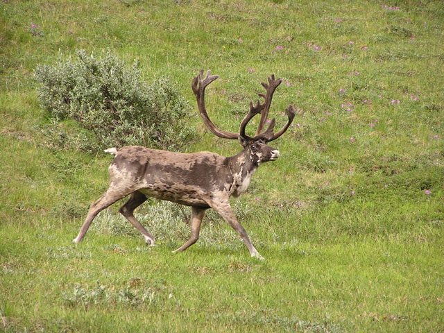
It was late by the time I got to my tent, and the Caribou was once again in the meadow, only this time he was about 20 ft adjacent to my tent. He even let me get about 10 ft from him. I guess he sensed that I was no threat from the other night. I was snapping away with my camera. I walked slowly around him to get the beautiful mountains in the background. His rack of antlers were large and fully grown, with velvet covering it's exterior. I was watching him for what seemed like hours before he finally walked up the ridge out of sight. I could tell those antlers must have weighed a ton as he had to pull his head up and balance it on his head when he walked.
.
That night I woke up again at about midnight and figured gazing at the amazing scenery would be my new nightly ritual from here on out. It was really hard to sleep with so much daylight late in the evening, and I wouldn't get a view like this in a while.
The next day I got my gear together and dropped down to the valley for the trek back. I decided to take a shortcut to the road that one of the Park Rangers had suggested. It took some serious uphill bushwhacking, but I finally found a game trail up to the road.
I dropped my pack, waiting for the Camper Bus to pick me up for the 2nd leg of to Mt. Eielson.


You can scroll down to view the pics. I tried to fit the experience in as short a TR as possible, so you probably can tell how incredible a place Denali is by seeing how utterly I failed. Enjoy!
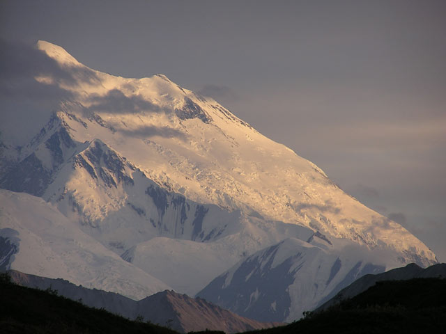
Mt. Eielson is disputably the most popular section of Denali National Park. The unit that Mt. Eielson (13) sits in is so popular that there wasn’t an opening for 3 days. One of the reasons why it is such a ‘hot spot’ is that, other than the Entrance, it is the only other place in the park with a visitors center. Most importantly though, it is the first spot in the road where you are able to see Mt. McKinley in it’s entirety on a clear day.
Due to a series of logistical problems I had to hike into Eielson a day before I was technically allowed to be there. I got to the visitors center by bus, and accessed my cache I had previously stored there. Beef Jerky! Gatorade! Gum! I gorged myself on all the things I should have brought with me to Toklat. I later confirmed that IT IS possible to wash every human body part in a small public restroom sink, though much sympathy to those who used it afterwards.
I tried to garner the sympathy of the attending Ranger to see if he would allow me to camp at the base of the visitors center. I had just hiked in 6 miles from the Toklat that day, and had little energy to hike another 6 miles into the Eielson unit. The Ranger wasn't sympathesizing AT ALL, and he informed that I either hike at least 2 miles out of the sightline of the road or risk a citation.
Technically, I had to hike 6 miles into the valley and UP INTO the pass just below the summit to Mt. Eielson, just to make it into the ‘unit’ I was supposed to be assigned to that night. That wasn’t going to happen Ranger Bob, and that was just ONE of the many problems with their quota system in Denali.
Anyhow, the day was very foggy, so I was going to hike to the nearest area where I figure I couldn’t be seen and set up camp. It was wet and muddy, and I had to hike down a steep hill. I ended up getting thick mud all over my pants, hiking poles, you name it. So I changed into some clean clothes and slipped again. Mud City! It had rained the previous night so that meant that I had to whack through bushes that were carrying about 5 gallons of water each, all to dump on my head when I came through. By the time I made it through the brush and into the river valley I was soaked head-to-toe.
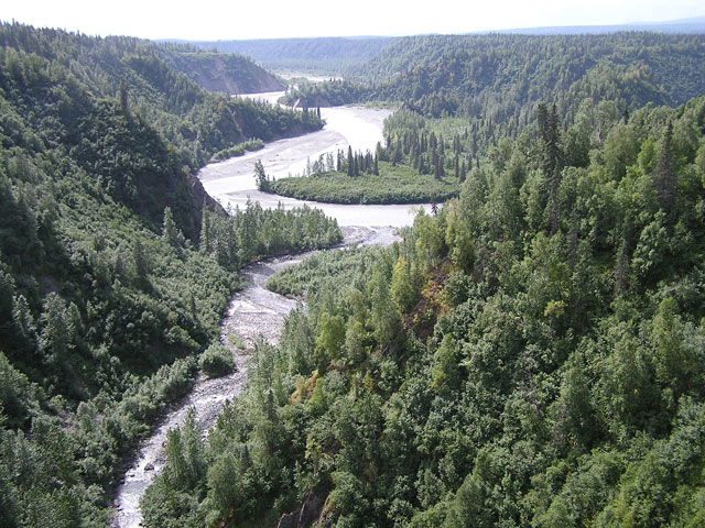
The Thoroughfare River was a similar size to the Toklat River but more braided, and thus easier to cross. What do I mean by braided? Not to insult anybody’s intelligence but it means the river isn’t one channel of water but rather spread out among many channels of waters. So it’s not always one big river, but a series of smaller rivers running alongside and interwoven across each other.
I was lucky enough to find a hill very close to the road, and it had a little niche that was big enough to hide my campsite. I set up camp and drenched my body in insect repellent. There were no available water sources, other than the glacial silt filled rivers, so I conserved my water as best I could. It was a long day of hiking, logging about 12 miles trailless miles. Though slightly exhausted I still couldn’t get more than 4 hours of continuous sleep.
The next day greeted me with some drizzle. I got started early and had crossed the Thoroughfare River’s many braids without much difficulty. I spotted another hiker on the other side of the river but he didn’t see me so I continued down the valley east of Mt. Eielson.
I searched for the access point on the other side of the river, soon finding the stream that leads up to the pass behind Mt. Eielson. I had to decide on whether I wanted to follow the stream up or ascend a ridge that runs parallel to it. The ridge looked to be nice and green going up and the chances of encountering some Dall Sheep were much greater, so I made my way up via this route.
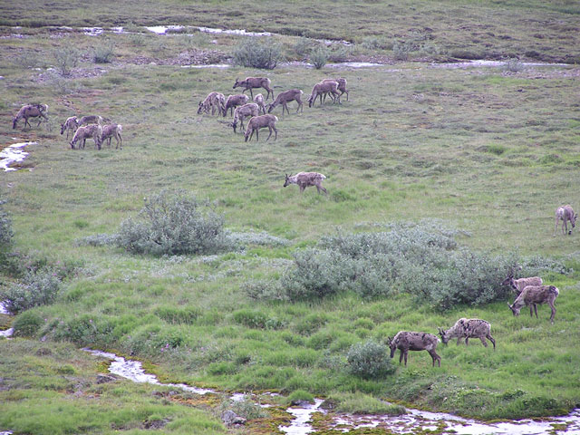
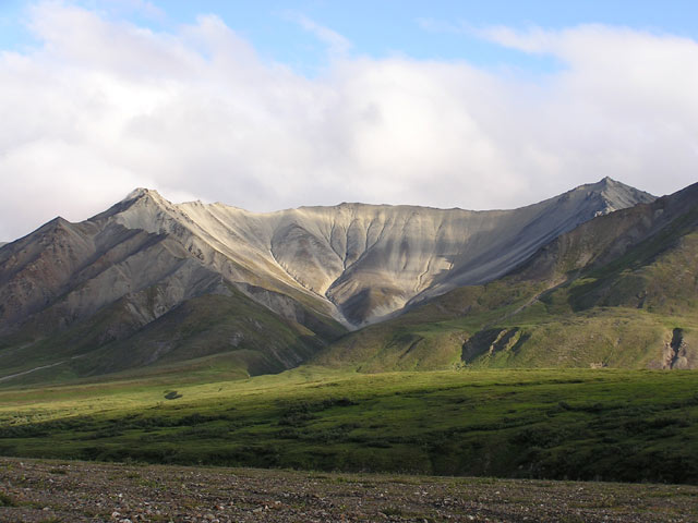
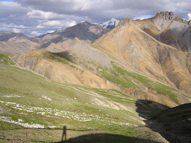
It was a nice climb up. I got up a good 1000 ft when I turned around to get a good look at the valley. Bald Mountain, on the other side of the valley, had an incredible large, flat bench sitting right below the summit, looked like a nice spot to camp. What made it incredible is the 40+ Dall Sheep that littered the bench from east to west. I had never seen that many of them in one spot. I guess it was a great spot for them to keep out of the way of predators, since you couldn’t see the bench from the valley floor and it had a nice meadowy area over it for grazing. Too bad I had gotten up so high on this ridge, it was almost worth going back down, crossing over, and climbing up that side. Just for the pictures!
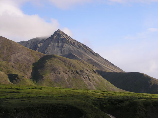
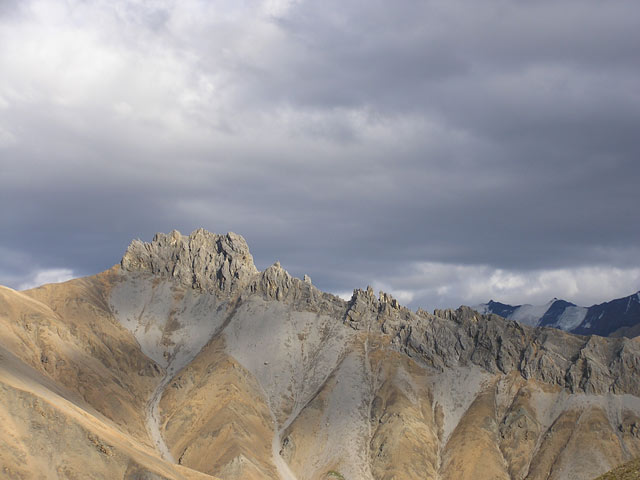
So I trudged up the ridge further and Castle Rock came into view to my left. It was a nice length of jagged rock that resembled the length of wall you would find on a…castle. There was one piece of rock that sat right in my eye-line, and it looked very distinct. For some reason I couldn’t get a decent picture of it, nothing to do it justice anyways. It looked great though coming up on it, with the cloudy sky in the background.
By this time I was down to a quarter Nalgene of water. It took me another 30 minutes to get to the top of the pass and drop down to Wolverine Creek for resupply. According to my topo map I needed to skirt another ridge before I arrived at ‘Pass Summit’, a pass sitting directly behind the summit of Mt. Eielson and a great spot for setting up tents. I ascended up the creek and found a neat game trail to skirt the ridge behind Eielson and get to the pass.
The game trail made me a little nervous as it drifted over some small, loose rocks on the slope, and altogether, with my gear, I was moving at 240 lbs. This trail started going up in elevation a bit, in some exposed areas, and the trail was tiny. It looked intimidating, but I kept surefooted and soon leveled out into a more manageable rock field scrambled. I found Pass Summit, which acted as a conduit for all the wind gusting through area.
High up on a ridge I could see 8-10 Dall Sheep chilling out, but they blended so well with the white rocks I decided against wasting any pictures on them. For about an hour I rested, rehydrated, and debated on whether it was too gusty up here to set up my tent. I really wanted to stay here though because it had a commanding view of the valley on the other side, and waking up here tomorrow morning would present an opportunity, my first, to get a clear view of Mt McKinley.
I tried setting up my tent and had to put rocks on everything to keep things from flying away. Rocks inside my tent just to keep it in one spot, and I wasted a couple of hours stacking a nice rock wall to protect the front side.
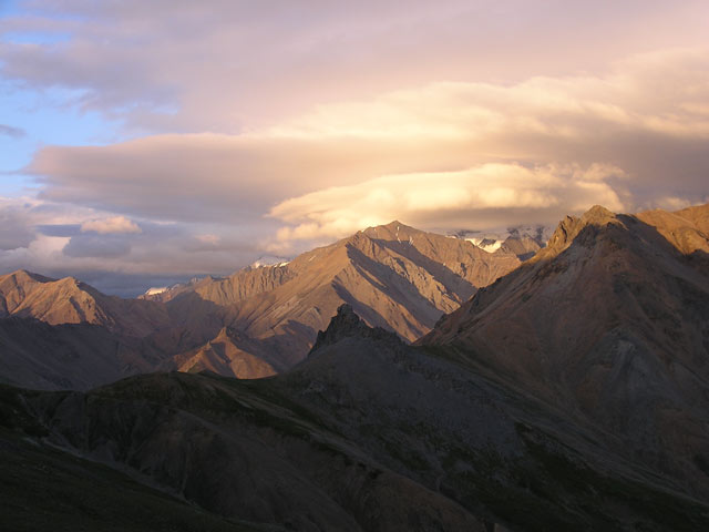
The Sun was setting low on the ridge and the length of Castle Rock was just lit up so I got my camera to take some choice shots. Wow! The ridge along Bald Mountain had some cool cloud formations over it. Click, click, click.
I soon realized that I wasn’t alone up here. A man and his wife passed by and we chatted for a bit. It seems they had camped on a spot on the other side of Wolverine Creek. I had walked right by their tent without even seeing it, but it was visible now from where I was. They had come from Montana and we shouted at each other over the steadily increasing winds just so we could hear. We were both planning on summiting Mt. Eielson the next day so I figured I’d run into them again down the line.
Let me stress how such a nice spot Pass Summit was. You had mountains all around, and a good vantage point. To the west I could see the length of Muldrow Glacier, covered in rubble, which made it seem like nondescript brown hills. Heavy fog enshrouding Mt McKinley and all the mountains around it. Mt Eielson to my north, Dall Sheep high up on some ledges. Castle Rock to the east, with Bald Mountain in the distance behind it and the slew of Dall Sheep on it’s bench. It can be a little overwhelming to the senses to have all this stimuli around you. I had headaches the first few days in Denali because there was no good place to rest the eyes, everything was great to look at.
So I bedded down for the night, trying to ignore the distraction of my tent flapping in the winds. At around midnight I woke up because I kept hearing an odd sound. I thought that it might be just a ground squirrel or marmot. It sounded like a sheep. In my grogginess I wondered if some of those Dall Sheep could have come down near my tent.
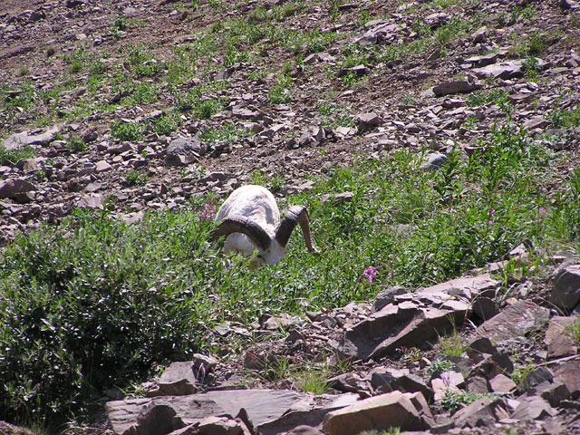
I opened my tent flap and crept up, but I couldn’t see anything. I descended down from the pass to relieve myself and ran into a mother and baby Dall Sheep laying down on the path. They turned the other direction and just bolted across the ridge in a full sprint! I didn’t think they could move that fast, over loose rocky slopes and steep, uneven terrain. Very impressive. I got a nice picture of a sheep head and two blurry figures hauling ass away from me. Later I saw see them on the other side of the ridge casually trotting out of view.
Early the next morning I was still sleeping, but at about 10 am I finally got up to assorted aches, pains, and a fat lower lip for reasons I know not. I got my gear packed up and decided that I was going to scramble up Eielson from the slope directly adjacent to my campsite. I could see a few ledges up above where the Dall Sheep were hanging out yesterday and figured if they could get up that way I could also.
The slope consisted of a variety of loose scree, and let me emphasize ‘loose’. I had to be careful about picking out my route as the entire slope wasn’t very stable. A couple of times every rock I was in contact with started shuffling downslope. I thought that if I kept to where the larger rocks were it would be easier, but even those rocks shifted. This slope was getting awfully steep as well, and I could only find a couple of spots where I was able to sit and rest. I will admit some anxiety crept in, this being the first difficult scrambling I had done since I got hurt up at Vesper Peak a month back. I got up to a portion of the slope that was all small, loose rocks. It was so steep that it couldn’t find any bigger rocks.
Every point of contact on the slope was moving and I had to lunge upward just to get to a rock that looked like it may not slide down if I made a grab for it. I felt like I was trying to walk on all fours across a floor strewn with marbles. Early on I saw the couple I met earlier taking the conventional route up to Eielson’s ridge. They had a good view of where I was so in the case I busted my ass someone would be in the vicinity to help. I had gotten to a portion sitting right below the summit ridge, but it was so precarious that I could have been as far away as China for all it’s worth. I took a couple of chances, stabbed at the slope with my hands, and pulled myself up by grabbing a few small rocks that shouldn’t have held, but they did. It was no use trying to pull my way up as the ground gave away too easily. I was only going to get up if I took it slow and disperse my weight as much as possible between my feet and hands.
I knew there was no way I was going to go back down this stuff, so my choice was made for me. Finally, I got up to the top of the ridge and thank God for vegetation and roots, to hold these rocks in place. I spent alot energy and more time than I thought I would getting up. I knew I could go back down an easier route farther down on the ridge, but I was still keyed up about the predicament I just wriggled out of a second ago. It is always great having other humans around though when you take risks, and I was glad to see the couple coming my way atop the ridge a few hundred yards back.
By this time the game trail atop the ridge was quite visible and I followed it down. I could see the entire north side where the road was and the visitors center situation alongside. I wondered if any tourists could see me from there, with their binoculars and glossy brochures in hand.
While I was skirting the ridge I spotted a section of small loose scree that seemed to drop off steeply to the side of the ridge back down where I came up. It was a narrow strip. I had no idea if anyone was crazy enough to descend down it. It was so steep that the upmost section near the ridge was cliff-like and I had to lean over just to see how it swept down the slope. It seemed to be small, loose scree the entire strip down. Hmm….no way!
I began to think about this entire ‘trailless experience’ and the difficulty in trying to find your own route. It really dawned on me, how hard it is to blaze a new path, how time consuming. That was the exciting thing about Denali, you aren’t given a trail, only rough directions on how to get somewhere. What I realized quickly, and I know this is going to sound cliché, is that destinations are less meaningful and the route is where the meat of the experience is. This place was just so rich, in so many ways, you weren’t concerned about getting to this or that mountain, it was all there for you. I experienced more great sights just shuffling out of my tent late at night than any of the day hike destinations I finished. It was a very different experience from my normally destination-focused hiking in Washington.
I scrambled up the last portion of the ridge to the summit and found a perch in between Dall Sheep droppings, which were all over the place. Unfortunately the Sheep themselves were nowhere to be found. Maybe my catlike climb up the slope scared them away.
The couple finally arrived and we chatted for a bit, waiting for a chance glimpse of Mt. McKinley to open up among the clouds. I forgot how much I missed good company. We discussed a bit about how we were going to descend down. The guy mentioned that he was thinking about going down that strip of scree I checked out earlier. I told him that I would probably take the safe route back. Of course I told them that I would be kind of enough to sit and watch to see that they didn’t eat it on the way down, in case they needed me to call for help.
Who am I kidding? I thought I’d use them as lab monkeys, if the experiment worked then I’d go down as well. The guy seemed to be very experienced in climbing and hiking, and I instinctively trusted both of them after a brief conversation, so I actually decided already that I would go down with them. Anyhow, we descended back down to the scree ledge. I watched as he grabbed her hand and they plunge-stepped slowly down this slope! Sure they were causing small rock slides, but nothing that caused them to lose their balance or loosened any dangerous rocks. I have to say I was relieved and impressed. I didn’t want to start until they were way down the slope so I wouldn’t present a falling rocks hazard. I could hardly wait for them to get to the base of the slope before I charged down. I had to slow down a bit as I loosed some large rocks to my sides, but I was amazed on how malleable the slope was. It was so forgiving that even in a few extremely steep sections I could comfortably dig my heels deeply in the scree to keep my balance.
So it took almost 2 hours up and about 15 minutes straight down. I was almost embarrassed at the amount of worry I put into this entire climb. I guess things always look worse than what they really are, all you can do is keep your head about you and you can make it out of the hairiest situations. I often harp about keeping those dreaded humans as far away as possible when I am out in the wild, but you can never discount how valuable another set of eyes are out there. I would have never chanced it down that seemingly difficult slope without a more experienced person there to show me that it was ‘doable’. I am sure that scree slope would have seemed obvious to a more experienced hiker, but as experienced as I am there is always something I can learn from others out there. So it was my little ‘golden gem’ of knowledge for the day.
I got down in great spirits and soon parted ways with the couple. They had a lot of good advice for me since they came up the valley that I was now going to drop down into. They told me that the best views of McKinley in this area are where I was headed. They even got a couple of glimpses a few nights ago of the massive mountain. In my entire backcountry trip, the Mt. Eielson leg was my only opportunity to get a view of McKinley. So far all I got was massive cloud-cover, hopefully luck will be with me in the next couple of days.
Having gotten to the summit of Eielson, the rest of my day was free to drop down to the valley on the other side behind Mt. Eielson and set up camp. Now the temperature up in the pass was a brisk 60 degrees and with a wind-chilled 34 the previous night. I was lumbering down along a stream to the valley below but for some reason I was just beat. I figured the Eielson scramble must have taken more out of me than I first thought. I guzzled copious amounts of Gatorade but it wasn’t helping. I checked my temperature gauge on my altimeter and it read 88 degrees. I wasn’t sure how the heat snuck up on me like that.
I descended down to Icicle River, filled with the glacial silt that made drinking hardly possible. I was dismayed to realize that the stream I followed down into the valley terminated a quarter mile back where I came. I set up camp and made the climb back up to wash myself and get some drinking water. It was a liberating feeling stripping all my clothes off and just washing in ice cold stream water. I thought for a second about the possibility of other hikers spotting my naked figure and laughed at myself, screw it! With no mosquitoes in the vicinity I hung out for a good hour, feeling like one of those old men you find at every nudist colony. Just hanging out!
Sleep was hard to come by, with the combination of heat and 20 hour days. I accidentally set up my tent with the rain-fly window facing the Sun, so I wasn’t helping out my situation. I bedded down to try to sleep, woke up out of my daze to a loud splashing outside of my tent. A large Caribou had just come storming through the river, obviously in a rush for some reason. Later that night I came out to relieve myself, finding a nice bushy spot.
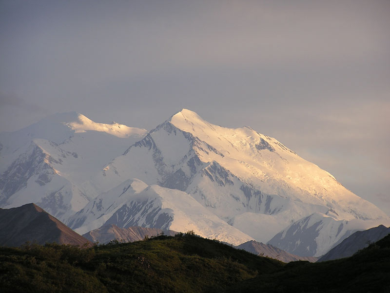
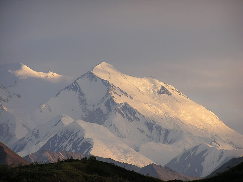
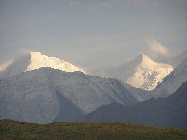
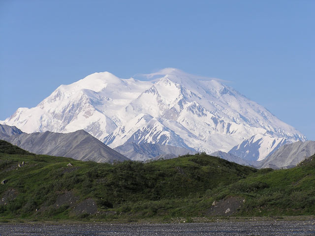
As I headed back to my tent McKinley hit me in the eye, a dramatic display of purplish sunlight revealed the juggernaut, half of it exposed, and clearing up with each minute that passed. I ran back to grab my camera, and clicked away. The lighting was incredible. It was a rarity just to get a glimpse of the mountain, but in this lighting at 1am in the morning? I was so overjoyed I fought the urge to run back up the pass and tell the couple about it. They were missing a great display. I stayed out, waiting for the clouds to move, my pictures tracking the progress of it’s exposure. After the mosquitoes took about 2 pints of blood out of me I reluctantly decided to get back to sleep. I really wanted to pull my sleeping bag outside and find a nice lean-to, just watch McKinley the entire night. But there was only flat terrain, no real spots to enjoy the view.
The next morning I got up and was surprised to see that McKinley had cleared up in it’s entirety, from base to summit, east to west. It was clear all the way through. Now I really wished I had someone to share this sight with.
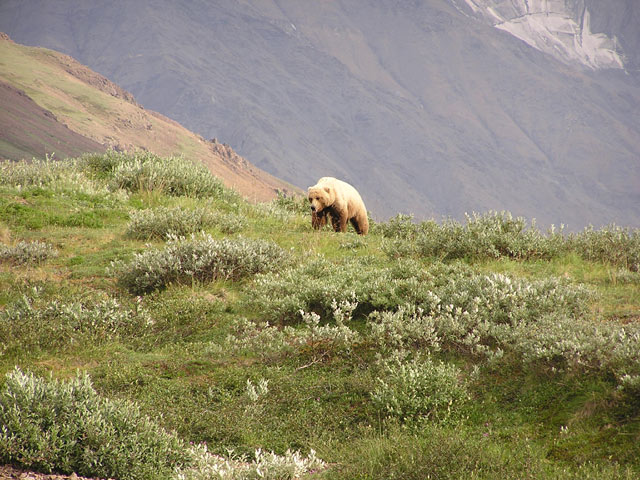
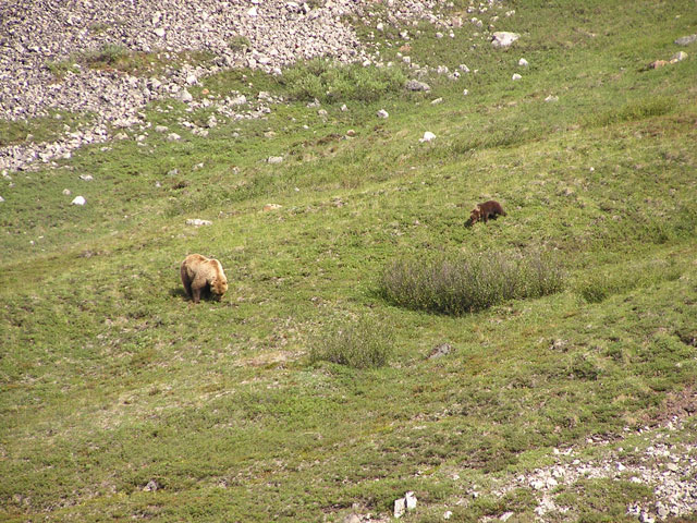
I had an entire day to kill, since I scrapped the overly-ambitious plan to hike to Anderson Pass. I headed over to the stream to get some water when I spotted a ball of fur further up toward the valley. It was a Grizzly Bear! I rushed back to my tent and thought about packing up and heading out for a little bit. Naww! I put all my goodies in my bear proof container and decided I’d try to get a closer look at the bear.
There was a grassy hill just south of the bear’s location. I decided to go to the top of it and see if I could kill a couple of hours watching the ole Grizz do her thing. The area was steep enough to discourage a fully charging ball of fur from making me her next meal while at the same time I got a unobstructed, comfortable view of her.
I soon spotted her Cub amble down after her, going from bush to bush munching on soapberries. The Cub was a character, he(?) was jogging along and around the mother. You could tell that this valley was a place that they came quite often. The mother was a sizeable Grizzly, though not the biggest I had seen.
Quick fact: Usually the size of a Grizzly mother is directly correlated with the number of Cubs. Grizzly mothers automatically abort pregnancies if they aren't carrying the size, and fat, necessary to support the child (The Visitors Center is good for something)
The Mother, with junior in tow, began to climb a grassy slope on the opposite side of the valley. So I made my way down into the valley to hopefully get some good shots. Mom laid down on her back, and junior got on top, and started suckling from the Mother’s breast. I started making my way closer and closer. Then the Mother sat up and began to squint in my direction. Man! A chill ran down my spine as she looked seemingly directly at me. I froze in place for a bit, then Mom sat back down. I didn’t want to end up in a footrace for my life so I squatted down at my present location.
Finally the Mother made a spine tingling growl and shoved junior off of her. She proceeded to, what I interpreted as a, lecture junior with a few more angry growls. Honestly though, I was making my way as quickly as possible back up the hill to safety.
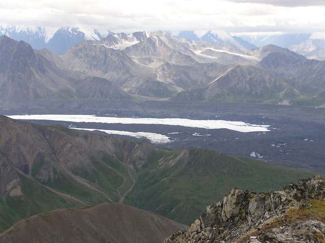
I decided to spend the rest of another hot day hiking onto Muldrow Glacier over to an exposed portion in it’s interior. Atop Mt. Eielson I had spotted an long strip of icy, exposed glacier about a mile into Muldrow. It looked interesting enough so I headed out.
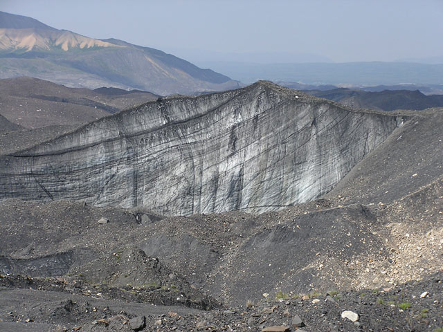
Muldrow Glacier is one LONG glacier, almost entirely covered in rock, dirt, and debris. From a distance, it looks like just another set of hills, only without much vegetation on it’s surface. I crossed over Icicle River and made my purchase onto the glacier. It was fascinating going over the glacier because the debris sitting over top of it is constantly moving at various locations.
Throughout my hike in I spotted sheer exposed icy cliffs 50-80 ft in height. The glacier was melting, so there were active streams flowing on beds of ice, into various small and medium-sized lakes enclosed by ice on most sides. I hiked to the top of one of the small exposed ice cliffs, it had rubble on top of it that would periodically tumble down as the ice melted. There were pretty big rocks and boulders balanced at the edge. I decided to push a few over, which had some satisfying ker-plops(!) into glacier ponds at the base. This was very interesting terrain! A couple of times I slid right down a slope WITH the rubble when I misjudged how shallow the pile I was stepping on was.
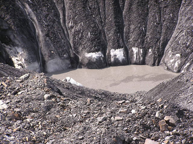
Soon I got to the exposed glacier and there was a river cutting into its side, flowing briskly north. Various large boulders were being held up by natural ice pillars. There was an inordinate amount of flies buzzing around and these weird circular moss balls that seem to be feeding directly on the cool ice glacier. I spotted a couple of dragonflies stuck to the side of the glacier. I was able to find a path into the glacier and found a gigantic rock at the top to eat a nice lunch.
It was pretty cool the organized way in which water melting at the top of the glacier travels to the river at the base of it. The glacier water traveled down relatively straight canals to the bottom. The narrow river had cut quite a deep bed, I couldn’t determine the depth, which was at least longer than two hiking poles.
I made my way back to camp, having to detour around some glacial cliff areas that prevented safe passage a good quarter mile radius in all directions. That’s the last time I try to take shortcuts through here.
The rest of the hike was uneventful, save for a Gap hat I found laying in a clearing. It was probably some darn Seattleite out here littering pristine areas with their brand name clothing again!
I took a nice afternoon nap, which led into a long evening sleepfest. The next day I prepared my gear for the hike back into civilization. I looped back around the other side of Mt. Eielson and encountered three pretty girls heading the other way. We chatted for about 30 minutes, they had all quit their jobs in San Francisco to come out hiking in Alaska for 1 month. I gave them the rundown of the terrain I just covered, about as long as this TR, but they appreciated every bit of useful info. They were going to Anderson Pass, the hike I decided not to do.
I finally broke away and hiked to the valley sitting in front of Mt. Eielson. I decided that I was going to cheat a little bit and hike to the base of the ridge directly below where the road sits, and find a spot to set up camp out of sight of those citation-writing Rangers.
I had to recross the Thoroughfare River, which was much more unruly on this side of the valley. It was just very choppy, deep, and not branched enough to find a shallow crossing. I went up and down the riverside trying to find a safe crossing. Finally I figured I would have to do this the hard and wet way. I balanced my backpack above my body, and used my free hand with hiking pole for stability. Wearing my raingear I was able to navigate across without getting sucked under, about chest high water, and COLD!
I found a shaded spot, and those are hard to come by in Denali, and bedded down. All I needed to do was wake up the next morning and hike up the ridge to catch the Camper bus back to civilization.
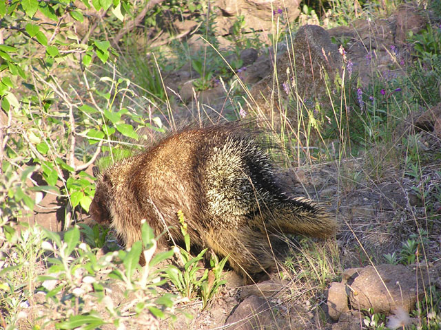
The next morning I was rudely awakened by some creature that banged into the side of my tent. I had no idea what animal it was. I was hoping it wasn’t a Moose that might stomp me to death, so I just laid down and remained quiet so the animal would move on. But I could hear the creature right outside my door, sitting tight where it was. I grabbed a pot and banged on it, but it didn’t go anywhere. It was making these whining noises, very anxious sounding. I didn’t want to frighten it, so I tried to talk to it. It finally began to walk away, so I slowly unzipped my tent door and it was a Porcupine!! This is the first time I ever saw one of those buggers, just waddling away from me. I thought it was a Wolverine at first, and maybe hoping since Wolverine sightings are very rare. But alas it was only a Porcupine, and I didn’t even get stabbed with any quills. How boring!
Anyhow, I geared up, bushwhacked up the ridge, following an obvious trail. Halfway up I found a fully functioning Thermarest pad that someone had obviously dropped on the ground. I can’t say that it wasn’t a great way to finish off an incredible few days in Alaska.
Thanks for reading my TR!

Last modified: 8/02/2005 9:10 AM