WHY SO DIFFERENT?
EXAMINING THE METHODOLOGIES USED IN TWO OLD GROWTH FOREST MAPPING PROJECTS
Presented at the
1998 International Geoscience and Remote Sensing Symposium
(IGARSS '98), Seattle, July 1998;
Robert A. Norheim
USGS-BRD Field Station for Protected Area Research
University of Washington College of Forest Resources
and UW Department of Geography
Box 352100
University of Washington
Seattle, WA 98195-2100
norheim@u.washington.edu
http://purl.oclc.org/net/norheim

ABSTRACT
In 1990, two different projects simultaneously mapped old growth in National
Forests in the northern spotted owl region in the Pacific Northwest. The two
projects used significantly different technology and techniques, and found amounts
of old growth acreage that differed by a factor of two.
This paper investigates the procedures used in each project to determine the
sources of the differing results, using four of the forests mapped as a case study.
The project carried out by Pacific Meridian Resources (PMR) for the U.S. Forest
Service (USFS) used Landsat TM imagery and sophisticated image processing
techniques, whereas The Wilderness Society project relied primarily on
photo-interpretation but also used Landsat MSS imagery. The USFS project
quantitatively mapped different size and structure classes, but The Wilderness
Society's project attempted to qualitatively categorize several variations of old
growth. The projects operated under tremendous deadline pressure, had vastly
different budgets, used very different hardware and software systems, and had very
different techniques for ground truth and accuracy assessment. Thus, despite the
fact that their goals were identical, these factors caused significantly different
results.
INTRODUCTION
In 1990, two different projects were conducted to map old-growth forests in the
Pacific Northwest. Both used the same, ecological, definition of old growth. Both
mapped the same region, using data of similar vintage. Both used remote sensing
and GIS. They were conducted simultaneously and took about the same amount of time
to complete. However, the two studies came out with different results that
differed by more than a factor of two. How could two such similar projects
disagree by such a large amount? This paper compares the methods used, in an
attempt to understand this difference. A companion paper [1] takes a step back and
examines the institutional context in which the projects were conducted, including
the contentious atmosphere that surrounded old growth, and how that context might
have affected the methodologies described here (e.g., budget, timeframe).
DEFINITION OF OLD GROWTH
Determining what constitutes old growth was an essential starting point for each
project. Each mapping project adopted the same definition for old growth forest,
one based on ecological characteristics. This definition, known as "PNW-447"
specified a number of criteria that a stand must meet to qualify as old growth,
including size, density, age, number of snags and downed logs, structure of the
canopy, and species mix. There are different threshold values for these criteria
for different parts of the region, to take into account species variation in the
different parts of the range, due to climate and topography. The definition
considered but did not include a minimum stand area criterion because different
management objectives require different minimum sizes of stands. It did emphasize
that any inventory using the definition would have to determine a minimum acreage
for a stand based on management objectives [2].
However, even though both projects used PNW-447 as their old-growth definition,
they actualized the definition differently. A major difficulty for both projects
was that not all of the components of the definition - in particular, snags and
downed logs - can be ascertained by the remote sensing devices employed by the
projects. Thus, PMR's definition simply specifies that a stand must be multistoried
and have a minimum crown closure among trees of a certain size (dependent on
elevation and latitude), and be a minimum of 10 acres to be considered as old
growth.
The Wilderness Society mapped what it called "Ancient Forest". For four national
forests, the Society defined and mapped separately three categories of ancient
forest: "old growth", "high elevation ancient forest", and "other ancient forest".
For the other eight national forests, Morrison mapped "ancient forest" (with no
distinctions among the subcategories) and "high elevation ancient forest." For old
growth, they mapped stands that had a high probability of meeting the PNW-447
criteria. The "other ancient forest" category consists of stands that meet only
some of the characteristics of old growth. Morrison used 5 acres in the
photo-interpreted forests and one 80m square MSS pixel (about 11/2 acres) in the
forests mapped using satellite imagery.
PROJECT METHODOLOGIES
This section outlines the methodologies employed by each of the projects.
The USFS/PMR project
PMR used an innovative and rigorous technique of interpreting Landsat TM imagery
to conduct its mapping project. Specifics about the techniques are available in a
variety of sources, e.g., [3].
The technique involved several stages. During the image classification stage,
PMR used both supervised and unsupervised classifications and merged the results
using cluster analysis. PMR then manually compared the resulting classified image
to aerial photographs, plot data, and other similar data. The manual editing
corrected about 15% of the pixels. The procedure was repeated four times to
produce four pixel maps: species, canopy structure, size, and crown closure.
The next stage was polygon creation. Because USFS personnel were familiar with
maps that were products of photo interpretation, i.e., maps that had vegetation
polygons, the deliverables for the project were not raster maps but rather polygon
maps. PMR used decision rules similar to those used by photo interpreters to
create polygons.
The crown closure pixel map was processed first. The map was scanned using two
different scanning algorithms to smooth the data into polygons. For each
crown-closure polygon, structure pixels were scanned, to produce sub-polygons of
homogeneous crown c losure and structure. The procedure was then repeated for
size-class pixels, creating homogeneous polygons of crown closure, size, and
structure. The species pixels were grouped together into classes of like species
using USFS classifications, then the grouped species were scanned, converted to
polygons, and overlaid on the first set of polygons. Density scans were also used
throughout this process to determine a threshold for homogeneous versus
heterogeneous areas.
Lastly, PMR used several methods to check the resulting polygon maps for
accuracy. Draft maps were distributed to USFS personnel for review. Also, both
guided and random approaches were used to compare subsets of the draft maps to
photo-interpretation.
All the raster processing was performed in ERDAS Imagine on Sun workstations.
The polygons were created by conversion to GRID and then Arc. SAS was used for the
cluster analysis, and Oracle was used for some database work.
It is notable that PMR used the title "Potential Old Growth Map" in the first
set of maps they drafted. The USFS insisted that the term "potential" be dropped
from the title of the final version of the maps. This indicates that PMR felt that
the stands identified by their methodology were areas where old growth was likely,
but not certain, to be.
The Wilderness Society project
Peter Morrison directed the old growth mapping projects for The Wilderness
Society, and used a much more qualitative technique. He first worked on the
Olympic National Forest (NF) [4]. He felt it important to map past as well as
current forest conditions, to determine how the forest had changed over time.
Thus, four sets of photographs were interpreted, from 1940, 1962, 1980, and 1982.
Morrison selected "reference stands" that represented each of the classes that were
being mapped. Two photo-interpreters each interpreted every quadrangle on the
forest, comparing each stand to the nearest corresponding reference stand, and
Morrison checked each quadrangle as well.
After some field verification, Morrison used a 1988 Landsat MSS image to
determine which areas had been logged since 1982.
A variety of software was used in the process. Volunteers digitized the
interpreted stands in Atlas-Draw. From Atlas-Draw, the polygons were transferred to
workstation Arc/INFO and rasterized in GRID at the Washington State Department of
Wildlife. These coverages were transferred to PC-Arc/INFO and EPPL7 on a PC at
The Wilderness Society Seattle office. Morrison used ERDAS to perform the
classification of the Landsat image.
The Society was quite pleased with the results of Morrison's work on the
Olympic, but they were not pleased with the time that it took (over a year) nor the
amount that it cost. The northern spotted owl was proposed as a candidate for
listing as an endangered species the month after the Olympic study was released,
and a final decision was due within a year. They asked him to step up the pace.
Morrison thus used less intensive procedures for the next three forests that he
mapped. Only one year's worth of photos was examined. Only the Mt. Hood NF was
dual-photo-interpreted; Gifford Pinchot and Mt. Baker-Snoqualmie NFs were examined
by only one interpreter, plus checking by Morrison. The amount of field
verification was very limited and focused on borderline areas.
With continued pressure to get work completed even more quickly, Morrison used
Landsat MSS data for all of the work inventorying old growth on the remaining eight
forests. He used ERDAS to do a stratified, unsupervised classification for these
forests, using orthophotos and aerial photos to check the classification. The
images were topographically normalized. However, he ran out of time on the last
National Forest that he worked on (the Siuslaw) and no topographic correction was
performed there [5].
COMPARISON OF RESULTS
Project Results: Following the methods described above, the results of
the two projects were issued in early 1991 with total old growth acreages that
differed by more than a factor of 2. Total old growth acreage for the study area
was reported by the USFS as 4.3 million acres, and was estimated by The Wilderness
Society as 2.0 million acres. The Wilderness Society reported 3.7 million acres of
the broader ancient forest category.
Discrepancies: However, these numbers do not represent a direct
comparison. Despite the similarities of the projects (e.g., goals, timeline),
several factors complicate a direct comparison of the two studies. These factors
include the nature of their old growth definitions and the differing geographic
areas over which the studies were conducted.
Because Morrison mapped "old growth" as a subset of "ancient forest" for only
the four forests that were photo-interpreted, a direct comparison of old growth
acreage reported by the two projects is possible only for those four forests. For
the other forests, only Morrison's larger category of ancient forest can be
compared to PMR's old growth figures. Thus, the comparison in this paper will focus
on those four: Olympic, Mount Baker-Snoqualmie (MBS), Gifford Pinchot, and Mt. Hood
National Forests.
Within those forests, there are still some discrepancies about what parts of
those forests were mapped. These inconsistencies include border adjustments,
inholdings, and different treatment of areas administered by other national forests
Direct comparison: Table 1 summarizes the results of an
"apples-to-apples" comparison, including only areas mapped by both studies. The
overlap between the two studies of the old growth classification is quite small.
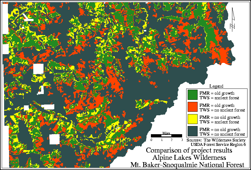
Clearly there is significant disagreement between the projects not only over how
much old growth there is, but where it is. A graphical comparison (Fig. 1)
illustrates this - the overlay shows no consistent pattern or bias. Areas mapped
as old growth or ancient forest by one study and not the other are randomly
distributed across the forests.
Table 1
Old Growth/Ancient Forest Comparison (thousands of acres)
|
National
Forest |
USFS / PMR "Old Growth"
|
Wilderness Society "Ancient Forest" |
Overlap |
Overlap as % of USFS/PMR
|
Overlap as % of Wilderness Society
|
|
Olympic |
148.1 |
191.2 |
104.6 |
71% |
54% |
|
Mt. Baker-Snoqualmie |
622.3 |
577.7 |
406.5 |
65% |
70% |
|
Gifford Pinchot |
477.5 |
291.5 |
224.0 |
47% |
77% |
|
Mt. Hood |
357.3 |
231.3 |
162.8 |
46% |
70% |
|
Total |
1,605.2 |
1,291.7 |
897.9 |
56% |
70% |
Figure 1
SUMMARY
Many factors contributed to the differences between the results
of these two projects. Simplistically, each project used the same definition of
old growth, and remote sensing and GIS technologies. However, the methodologies
were completely different -- Landsat TM and statistical models versus
photo-interpretation and Landsat MSS, and neither were completely appropriate for
assessing all of the characteristics of old growth in the definition.
Unfortunately, the lack of any discernable pattern in the comparison of the
projects makes it impossible to assess specifically how the differing methodologies
affected the results.
Many other factors surrounding these projects also had an effect on their
results. The short timeline that each of these large projects had, and the
different budgets (as reflected in the hardware and software that each project
used) with which they operated had profound effects on the methodologies used.
Furthermore, the institutional agenda of the projects' sponsors cannot be
discounted. See [1] for an assessment of the influence of these factors on the
projects.
FURTHER INFORMATION
More information, including further results of the direct overlay between the
two projects, including confusion matrices and maps, a full bibliography, the text
of [1], details of the geographic discrepancies alluded to, and other results from
this work, are available on the World-Wide Web at http://purl.oclc.org/net/norheim/oldgrowth.
REFERENCES CITED
[1] R. A. Norheim, "Dueling databases: examining the differences between two old
growth mapping projects," presented at 13th International Symposium on
Computer-assisted Cartography (Auto-Carto 13), Seattle, 1997. Available on the web
at http://purl.oclc.org/net/norheim/oldgrowth/dueling-db.html
[2] Old-Growth Definition Task Group, Interim definitions for old-growth
Douglas-fir and mixed conifer forests in the Pacific Northwest and California.
Research Note PNW-447. Portland: USDA Forest Service, 1986.
[3] R. G. Congalton, K. Green, and J. Teply, "Mapping old growth forests on
national forest and park lands in the Pacific Northwest from remotely sensed data,"
Photogrammetr. Eng. and Remote Sens., vol. 59, pp. 529-535, 1993.
[4] P. H. Morrison, Ancient forests on the Olympic National Forest: Analysis
from a historical and landscape perspective. Washington, D.C.: Wilderness
Society, 1990.
[5] P. H. Morrison, D. Kloepfer, D. A. Leversee, C. M. Socha, and D. L. Ferber,
Ancient forests in the Pacific Northwest: Analysis and maps of twelve national
forests. Washington, D.C.: The Wilderness Society, 1991.
Last updated: July 20, 1998
Copyright 1996-98 Robert A. Norheim and IEEE