DISTINGUISHING POSITIONAL AND ATTRIBUTE ERROR
IN TWO OLD GROWTH FOREST MAPPING PROJECTS
Presented at the
Eigth International Symposium On Spatial Data Handling
(SDH '98), Vancouver, B.C., July 1998.
Robert A. Norheim
USGS-BRD Field Station for Protected Area Research
University of Washington College of Forest Resources
and UW Department of Geography
Box 352100
University of Washington
Seattle, WA 98195-2100
norheim@u.washington.edu
http://purl.oclc.org/net/norheim

Keywords: attribute error, positional error, confusion matrix, categorical map, polygon overlay
Abstract
A test designed to distinguish positional error from attribute error, posited by
Chrisman and Lester (1991), is applied to overlays of two old growth forest
datasets. These datasets are more complicated and cover far more acreage than
previous applications of the test. In the test, polygons whose boundaries are
equally derived from the two different source layers are identified as positional
error. The results of the error analysis show that positional and attribute errors
clearly are drawn from different populations. Because the two types of errors have
different sources and have different implications, it is useful to distinguish
between the two.
Introduction
In 1989, two different projects set out to map old growth in the Pacific
Northwest. Despite their identical goals, timeframes, definition of old growth and
other similarities, they produced very different results. An examination of some
of the differences that led to these results, and a closer review of the results,
can be found in Norheim (1996, 1997).
In that analysis, however, no consistent trend was found in any of the
disagreements between the two projects. Nevertheless, understanding the nature of
error in a dataset is necessary before deciding to use a dataset for any given
purpose (Goodchild and Gopal 1989). Because the stakes in the old growth
controversy were so high, and because critical decisions were being made on the
basis of these datasets, a full understanding of the error in them is particularly
important.
One possible way to refine the analysis would be to better characterize some of
the disagreement between the two studies. Congalton and Green (1993) identify
several different sources of confusion, including registration errors, digitizing
errors, interpretation error, temporal problems, and classification errors.
Goodchild et al. (1992) proposes an error model for categorical data. Several
papers suggest the use of fuzzy logic to better describe the boundaries between
polygons (Lowell 1994, Lowell and Edwards 1994, Edwards and Lowell 1996). However,
these procedures have limitations in many real world applications. Specifically,
they require previous knowledge or assumptions about the nature of the error that
is present, which is often not known.
In response to this problem, Chrisman and
Lester (1991) propose a diagnostic test for error in an overlay of categorical
maps, one which requires no previous knowledge of the nature of the error in the
sources. The test examines the geometry and topology of an overlay, thus
retrospectively making a categorization of the errors present in the overlay. The
test distinguishes between errors that appear to arise from positional disagreement
in the source layers versus errors that are likely to result from attribute
disagreement, using decision rules that are based on experimental evidence
regarding the relative geometry and topology of positional and attribute errors.
Positional error is more likely to derive from the technology used, whereas
attribute error is more likely to be a more substantive disagreement over the
nature of the polygon in question (Chrisman 1989). As an example, Chrisman and
Lester (1991) apply the test to two different interpretations of the same imagery.
This paper applies this test to the two old growth mapping projects, thus
applying the test for the first time to two sources that are entirely independent
of one another. It is the intention of this paper to gain further insight into the
differences between the two old growth mapping projects by distinguishing
positional from attribute error in an overlay of the two, thereby better informing
our use of the two datasets.
Data Sources
In 1988, the National Forests in the Pacific Northwest were in the middle of the
spotted owl controversy. The Forest Service was logging old growth forest at
increasing rates. However, old growth forest was the only habitat for the spotted
owl, which was on its way to the endangered species list as a result of the
logging. A critical factor in the ensuing negotiations was how much old growth
acreage was left (Hirt 1994, Yaffee 1994). Environmental groups raised serious
doubts as to how accurate the U.S. Forest Service (USFS) acreage totals for old
growth forest were. As a result, Congress directed the Forest Service to inventory
its old growth (Congalton et al. 1993). Because of the tight deadline imposed by
Congress, the agency turned to an outside consulting firm that used satellite
imagery to complete the project (Norheim 1996, 1997).
The Wilderness Society began its own program of mapping old growth at about the
same time (Morrison et al. 1991). While they used satellite imagery to determine
recent clearcuts, the majority of the Society's old growth data for the forests in
Washington State was from photo-interpretation. This was a much lengthier process
than image processing, and the Society's team came under mounting pressure to
increase the speed at which they completed their project. Hence, as they continued
their photo-interpretation, they accelerated the pace of their work but thereby
they decreased the confidence they had in it (Norheim 1996, 1997).
Norheim (1996, 1997) compares these two projects and examines their many
similarities and differences. For the purposes of this paper, the two resulting
datasets are ideal for the Chrisman and Lester test, because they are from entirely
independent sources. While preferably for such a test we could assert that one or
the other data source was "correct", Norheim came to no such conclusion in his
comparison. Nevertheless, Chrisman (1989) states that a test for error in
categorical maps could also be a test of repeatability. Indeed, we are most
interested in the repeatability aspect in a test of the two old growth projects,
because Norheim was unable to determine from a simple overlay that there was any
systematic bias between the two datasets. Perhaps the diagnostic test can shed
some light on the reasons for the differences in the two projects.
Note that this paper will continue to use the term 'error' when describing
differences between the two datasets, as if one of them were correct, rather than a
more unwieldy term such as 'disagreement' or 'confusion'.
Nature of old growth polygons. The errors that might occur in the
boundaries surrounding old growth polygons in this region range from very sharp
(where an old growth stand is adjacent to a clear-cut) to very fuzzy (as when an
old-growth stand is adjacent to a slightly younger stand). Unfortunately, one of
the projects used as a source in this study was strictly charged with
distinguishing old growth without regard to neighboring stands. (A further study
made these categorizations several years later) (Congalton et al. 1993). While a
categorization of error based on fuzzy set theory (Lowell 1994) would be more
satisfying, the limitations of the data sources preclude this option. Thus, the
approach that is followed in this paper is simply an a posteriori
categorization of the different categories of error. It is not an attempt to
actually model the process from which the error was generated, but rather an
exploratory characterization (Chrisman 1989).
The test
Space allows only a much-condensed description of the procedure of the test in
this paper. The reader is referred to the original paper (Chrisman and Lester
1991) for a full description of the test and the rationale behind it.
The test involves six steps, and results in polygons being categorized in three
ways. Polygons can either be not in error, or represent one of two kinds of error.
Error can either be an attribute error, for example, one source has an island
polygon of clearcut within an area both sources otherwise classify as old growth;
or a positional error, for example, the two sources disagree on exactly where a
clearcut polygon ends, resulting in a sliver polygon when overlaid.
The sequence of the test is shown in the flow chart in Figure 1. Step one asks
whether there is indeed an error (e.g., are the attributes identical). The second
step asks whether the boundaries are mostly coincident within a specified
tolerance; if more than 85% of the linework agrees, the error must be an attribute
error. In the tests applied for this paper, a tolerance of 3 meters was used;
because the two sources were based on different grid sizes of 57 and 25 meters,
virtually none of the linework agreed.
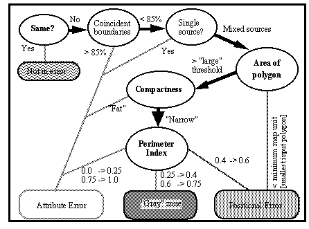
Figure 1 Flow of test applied to each overlay polygon
(Adapted from Chrisman and Lester 1991)
Step three looks at the source of the lines also; if all of the non-coincident
lines of a polygon are from one source, then it is an island of a different
attribute and not a case of partial overlap. The fourth step is to determine
whether a polygon is smaller to a specified "minimum map unit", in which case the
error is deemed to be positional as such a polygon is too small to come from the
data sources. In the old growth application of the test, the minimum map unit is
5625 m2. This figure is equal to nine 25 m grid cells, which is the size of the
filter applied when the Forest Service converted their pixel layers to polygons.
In step five, polygons that are relatively less compact are classified as
attribute error if they are relatively large. To do this, compactness and "minimum
compactness" values are calculated for each polygon. The compactness values are
based on Unwin's S2 (1981). The minimum compactness is based on the minimum
discrimination distance. Any polygon that is both larger than the square of the
minimum discrimination distance and more compact than the minimum compactness is at
once large enough and wide enough to have been identifiable in the source layers,
so it is reckoned to be an attribute error.
In the sixth and final step of the test, a perimeter index is calculated for all
polygons not previously classified. This index is a ratio of the perimeter from
one source to the total of the non-coincident perimeter from both sources. Chrisman
and Lester demonstrate that in a test where a source is shifted positionally and
then compared to itself (thereby all error should be a positional error), the
perimeter index for nearly all polygons falls between 0.4 and 0.6. Thus, in this
step, all polygons whose perimeter index falls in this range are classified as
positional errors. In the original version of the test, if the index is smaller
than .25 or greater than .75, the error is categorized as attribute with the
remaining polygons falling into a gray area, where it is not clear whether the
error is one of position or attribute.
However, Lester and Chrisman (1991) demonstrate further the significance of the
perimeter index. For polygons where the error is purely a contrived positional
error, all index values fall in a narrow range around 0.5. Further, a visual
inspection of the old growth overlay showed that polygons that would have fallen
into the gray area were generally quite intricate in nature, frequently with
internal islands. This is not a surprise considering the complexity of the two
input layers. Thus, in the version of the test that I applied, polygons that would
have fallen into the gray zone were instead considered to be attribute errors.
Applying the test
In an attempt to understand whether there was a consistent bias to either
positional or attribute error in the two old growth datasets, I ran the
Chrisman/Lester test against the two old growth coverages. This is the first time
that the test has been run against two coverages with completely different
provenances, against "real data" as opposed to more contrived situations. Also,
the test has been applied to only relatively small areas before, such as a
township. Now it is being applied at a massive scale - from central Oregon to the
U.S./Canada border, over four National Forests. Furthermore, the polygons on the
input layers are much more complicated than any that have been tested before.
Thus, it is also a more significant "test of the test" than has been run before.
The test was run in Arc/INFO 7.1.2 on a dual Pentium workstation using AMLs
adapted from the AMLs used by Lester and Chrisman. The
source code for the AMLs is included as an appendix to this paper.
Because the comparison of the old growth mapping results for each of the forests
shows that there were significant differences in the amount of error in each
forest, we expect to see significant differences in the results of the
Chrisman/Lester test across each forest. However, if there were no bias towards
either kind of error, we would expect to see approximately equal proportions of
each type of error in each forest.
Categories. The Wilderness Society project mapped three different
categories of what they referred to as "Ancient Forest". The category they called
"Old Growth" is the category of forest that meets the definition that both they and
the USFS used. The other two categories included "other Ancient Forest", which met
some, but not all, of the characteristics of old growth used in the definition, and
"high elevation ancient forest". Because the acreage totals the Society found for
ancient forest more closely match the acreage found by the USFS for old growth than
the acreage the Society found for old growth, I ran the test twice. First I
compared USFS old growth category against The Wilderness Society's ancient forest
category, then USFS low-elevation old growth category against the more restrictive
Wilderness Society's old-growth category.
Test Results
The results of the test vary widely for each forest. This is not unexpected
because the overall comparison of the forests' old growth acreage varied
substantially. However, it is significant that there are notable differences
between the proportions of positional and attribute error.
Tables 1 and 2 contain confusion matrices for the
overlays. In these matrices, attribute and positional error are differentiated for
the cells that are not on the main diagonal, i.e., the cells that represent
disagreement, or error. Positional error in all cases represents significantly
less acreage than attribute error. In most cases, across the four forests and two
different overlays, and for errors of both omission and commission, positional
error ranges between 1.5% and 3.5% of forest acreage.
In all cases, attribute error is at least 1.5 times higher than positional
error, in most cases it is at least 2 times higher, and in one case attribute error
contributes over 10 times as much error as positional error (Table 2c).
Unfortunately, because the USFS study produced what was essentially only a
binary map, old growth or not old growth, these are only two-by-two confusion
matrices. In the earlier example of an application of this test that involved
mapping several classes, positional error is shown to be relatively symmetric
across the main diagonal whereas attribute error is not at all symmetric, thus
showing that the two classes of error have different distributions (Chrisman and
Lester 1991). However, even in this case it can be inferred that the two classes
of errors are drawn from different populations of errors and should not be
conflated into the same error matrix.
Some examples of the characterization of the polygons resulting from the overlay
are shown in the Figures 2 and 3. Thin polygons surrounding polygons of old growth
are generally characterized as positional error. Embedded polygons are
characterized as attribute error.
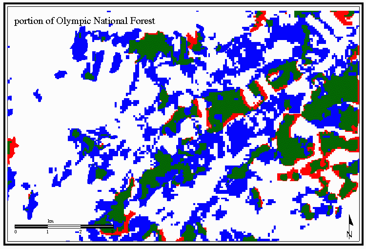
Figure 2 Example from Olympic National Forest

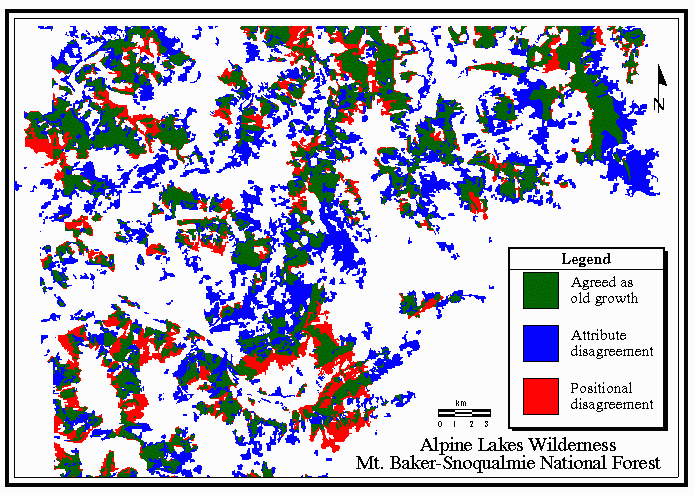
Figure 3 Example from Mt. Baker-Snoqualmie National Forest
The fact that the datasets were derived from satellite imagery is clear from
characteristic stairstep edges of the polygons. The narrowness of some of the
polygons identified as positional error points to the different resolution of
satellite imageryused by the two projects (57m Landsat MSS for The Wilderness Society, 25m Landsat TM for the Forest Service) as a likely source for the error.
Conclusions
For the overlays of the old growth datasets, attribute error was generally a
much larger component of overall error than positional error. Also, positional
error was a relatively constant proportion of the error. This is consistent with
the assertion that positional error generally is a result of the technology used to
derive the coverage. This is confirmed by a visual check of the overlay.
A characterization of error is a necessary part of understanding the nature of a
dataset and whether it is useful for a given purpose. Indeed, characterizations of
attribute and positional accuracy are important components of the data quality
report in the recent U.S. standards for spatial metadata (FGDC 1994). The test to
distinguish positional from attribute error in overlays of categorical maps gives
us one tool to make such a characterization and to yield something quantitative for
a metadata report.
While the two old growth studies were later used to delineate areas to protect
from logging, their more important and immediate purpose was more political - to
find overall acreage figures for old growth - i.e., habitat for the endangered
spotted owl. Being aware of positional error is more important when using a data
set for delineating specific stands on the ground. However, attribute errors are
more important when comparing overall acreages. Thus, that the more substantive
disagreement between the datasets was attribute error has implications for their
use in communicating old growth acreage/spotted owl territory.
Further research. This paper has used an exploratory a posteriori test to
better characterize the nature of the disagreement between the two old growth
datasets. Now, we can focus on identifying the sources of the two different kinds
of errors. The positional error largely seems to be an artifact of the technology
used. Thus, we can focus on the polygons that are categorized as purely attribute
error, because these are the polygons where the two studies truly disagreed. An
application of this test to a more current dataset would enable us to focus on
polygons which are attribute errors, thus making a field verification more
efficient.
ACKNOWLEDGEMENTS. The author wishes to thank Nick Chrisman,
Dave Peterson, and anonymous reviewers for many useful suggestions for this paper.
References
Chrisman, Nicholas R. 1989. A taxonomy of cartographic error applied to
categorical maps. In Proceedings, Ninth International Symposium on
Computer-Assisted Cartography (Auto-Carto 9). American Society for
Photogrammetry and Remote Sensing, Baltimore.
Chrisman, Nicholas R. and Marcus K. Lester. 1991. A diagnostic test for error
in categorical maps. In Proceedings, Tenth International Symposium on
Computer-Assisted Cartography (Auto-Carto 10). American Society for
Photogrammetry and Remote Sensing, Baltimore. Pp. 330-348.
Congalton, Russell G., and Kass Green. 1993. A practical look at the sources
of confusion in error matrix generation. Photogrammetric Engineering and Remote
Sensing 59(5):641-644.
Congalton, Russell G., Kass Green, and John Teply. 1993. Mapping old growth
forests on national forest and park lands in the Pacific Northwest from remotely
sensed data. Photogrameetric Engeering and Remote Sensing
59(4):529-535.
Edwards, Geoffrey and Kim E. Lowell. 1996. Modeling uncertainty in
photointerpreted boundaries. Photogrammetric Engineering and Remote Sensing
62(4): 377-391.
FGDC. 1994. Content Standards for Digital Geospatial Metadata (version
1.0). FGDC-STD-001. Federal Geographic Data Committee, Washington, D.C.
Goodchild, Michael F. and Sucharita Gopal, editors. 1989. The Accuracy of
Spatial Databases. Taylor and Francis, London. 290 pages.
Goodchild, Michael F., Sun Guoqing, and Yang Shiren. 1992. Development and
test of an error model for categorical data. International Journal of
Geographical Information Systems 6(2): 87-104.
Hirt, Paul W. 1994. A Conspiracy of Optimism: Management of the National
Forests since World War Two. University of Nebraska Press, Lincoln. 416 pages.
Lester, Marcus K. and Chrisman, Nicholas R., 1991. Not all slivers are skinny:
A comparison of two methods for detecting positional errors in categorical maps.
In Proceedings, GIS/ LIS '91. American Society for Photogrammetry and Remote
Sensing, Baltimore. Vol. 2, 648-658.
Lowell, Kim E. 1994. An uncertainty-based spatial representation for natural
resources phenomena. In Advances in GIS Research: Proceedings of the Sixth
International Symposium on Spatial Data Handling. London, Taylor and Francis.
Vol. 2, 933-944.
Lowell, Kim E. and Geoffrey Edwards 1996. Modeling heterogeneity and change in
natural forests. Geomatica 50(4): 425-440.
Morrison, Peter H., Deanne Kloepfer, David A. Leversee, Caroline M. Socha,
Deborah L. Ferber. 1991. Ancient Forests in the Pacific Northwest: Analysis and
Maps of Twelve National Forests. The Wilderness Society, Washington, D.C. 24
pages.
Norheim, Robert A. 1996. Is there an Answer to Mapping Old Growth? An
Examination of Two Projects Conducted with Remote Sensing and GIS. Unpublished
Masters thesis. Department of Geography, University of Washington, Seattle. 150
pages.
Norheim, Robert A. 1997. Dueling databases: examining the differences between
two old growth mapping projects. Paper given at Thirteenth International Symposium
on Computer-assisted Cartography (Auto-Carto 13), at Seattle. Available on the web
at the URL
http://purl.oclc.org/net/norheim/oldgrowth/dueling-db.html
Unwin, David J. 1981. Introductory Spatial Analysis. Methuen, London.
212 pages.
Yaffee, Steven L. 1994. The Wisdom of the Spotted Owl: Policy Lessons for a
New Century. Island Press, Washington, D.C. 430 pages.
Last updated: July 20, 1998
Copyright 1996-98 Robert A. Norheim and IGU GISc Study Group