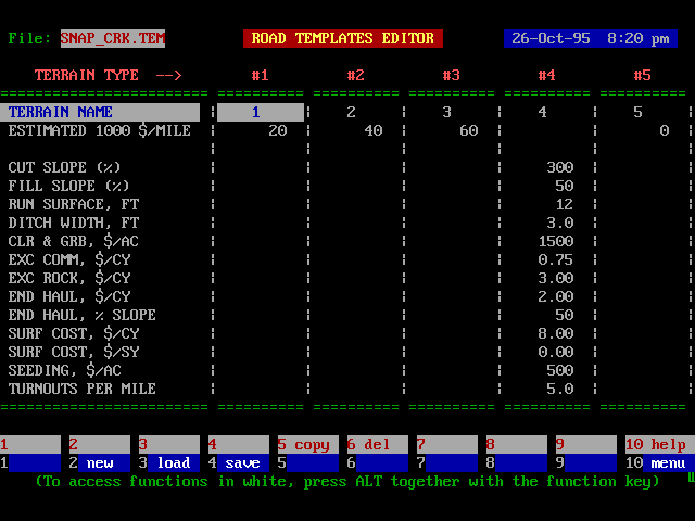
Road Templates Editor -- Row Definitions
|
TERRAIN TYPE LABEL |
Label describing terrain type/road template. |
|
EST 1000 $/MILE |
Default cost per mile. If this cost is entered, the detailed cost parameters are ignored. |
|
CUT SLOPE |
Cut slope, in percent. |
|
FILL SLOPE |
Fill slope, in percent. |
|
RUN SURFACE |
The width of the running surface, in feet. |
|
DITCH WIDTH |
The horizontal width of the ditch, in feet. |
|
CLR & GRUB |
The cost of clearing and grubbing per acre. This cost is multiplied by the slope acres within a balanced road prism or the slope acres of the road and cut slope if it is a full bench section. |
|
EXC COMM |
The cost per bank cubic yard of excavating and placing common material. Road templates are assumed to be balanced cross sections with a shrinkage factor of 1.15 for all excavated material, common and rock. |
|
EXC ROCK |
The cost per bank cubic yard of excavating and placing rock material. |
|
END HAUL |
The cost per bank cubic yard of end hauling excavated material. |
|
END HAUL |
The percent slope at which end haul begins. For this slope and steeper, full bench sections will be assumed. |
|
SURF COST |
The cost per cubic yard of surfacing material for hauling and placing surfacing material. |
|
SURF COST |
The cost per square yard of compacting surfacing material. |
|
SEEDING |
The cost per slope acre for seeding. |
|
TURNOUTS |
The average number of turnouts per mile. |
|
TURNOUT LEN |
The average turnout length. It is assumed that the total transition length for the turnout is 100 feet. |
|
PIPES |
The average number of culverts per mile. |
|
$ PER PIPE |
The average cost per culvert, in $. |
|
BRIDGES |
The average number of bridges per mile. |
|
BRIDGE COST |
The average bridge cost, in thousands of dollars. |
|
OTHER |
Any miscellaneous costs per mile such as move-in, in thousands of dollars. |
NOTES:
(a) A maximum of 99 road templates are permitted.
(b) Enter 0 in the EST $/1000 row to designate an existing road.
Special Function Keys
|
F1 |
Not used. |
|
F2 |
Used to clear all current values and alphanumeric entries from editor. |
|
F3 |
Used to access and load other .TEM files in the current directory. |
|
F4 |
This key allows you to save the current file immediately with the option of changing the filename. If you change the filename, then you will be asked if you wish to update the project filenames (this effectively means "do you want this new file to be retrieved when you re-enter this editor at some later date"). |
|
F5 |
Not used. |
|
F6 |
Not used. |
|
F7 |
Not used. |
|
F8 |
Not used. |
|
F9 |
Not used. |
|
F10 |
Used to return to the Main Menu. If you have made any changes to your data then they will be saved to the current filename automatically as you return to the main menu. To leave without saving changes use ESC, not F10. |
|
ALT F3 |
Used to jump to a line number. |
|
ALT F4 |
Not used. |
|
ALT F5 |
Not used. |
|
ALT F6 |
Used to access a file utility which can be used to delete, view, and hide files. |
|
ALT F10 |
Used to access the help screen. |
How Road Template Information is Used
Road template information is used to estimate road construction costs. Each road template is identified by its terrain type and a maximum of 99 road templates can be specified. Road templates should be established for each combination of soil condition and road standard that you plan to use. For example clay soil - 20 foot subgrade might be used for one template, sandy soil - 20 foot subgrade used for another, and sandy soil - 24 foot subgrade might be used for a third road template.
Two costing options are available: (1) Empirical costs are entered as a cost per mile or (2) an analytical road cost appraisal can be developed using a specified road template.
Empirical Road Costs
If you want to specify the road cost per mile directly without calculating road cost based upon link quantities then complete the first line in the Road Editor.
Analytical Road Costs
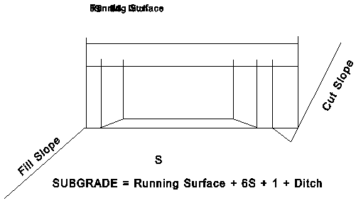
If you want to develop road costs based upon average link characteristics then leave the first line of the Road Editor blank and complete the road specifications beginning with the Cut slope, Fill slope, etc. Analytical road costs are developed based upon the road template you specify. A cross section of the road section used in SNAP is shown below.
Road Cross Section Used in SNAP
Road sections are assumed to be either balanced section or full bench. You control whether roads are balanced section or full bench by specifying the percent slope at which end haul would begin (Variable END HAUL, % SLP). SNAP assumes that if you will build full bench you will endhaul. If you plan to build full bench without endhaul, use a zero cost for endhaul volume.
Quantities are calculated in the following way. Earthwork is discussed first so that the template geometry can be defined.
Earthwork
For the balanced section the following equations are used:
Cut = B1y1/2 = B1A1x1/2 y1 = A1x1 = A2(x1-B1)
Fill = B2y2/2 = B2A1x2/2 y2 = A1x2 - A3(x2-B2)
B1 = {(A2-A1)/A2}x1 = Dx1 B2 = {(A3-A1)/A3}x2 = Gx2
and B1A1x1 = k B2A1x2 where k is the shrinkage factor.
The relationships for x1,x2 are
x1 = w/D -(G/D)x2
{kG - G2/D} x22 + 2 {wG/D} x2 - w2/D = 0
x2 is solved by the quadratic formula and the other output quantities follow directly. To convert the cut end area into bank cubic yards per mile multiply the cut area by 5280/27. The calculations assume an average shrinkage of 15% where the shinkage factor is defined as the cubic yards of cut required to make 1.0 cubic yards of fill. For example, a shrinkage factor of 15% means that 1.15 cubic yards of cut is required to make a cubic yard of fill. Ditch width is used to calculate subgrade width and quantities. Ditch volume contained in the ditch triangle is ignored.
Earthwork Nomenclature

For full bench the following equations are:
Cut = B1y1/2 = B1A1x1/2 = w A1x1/d
y1 = A1x1 = A2(x1-w)
x1 = {A2/(A2-A1)} w
An adjustment factor for quantities in turnout and turnout transitions by multiplying the cut in full bench and balanced sections by a percentage factor defined as
1 + 1.5 x turnout length x turnouts/mi
Factor = ----------------------------------------------------5280
This factor is used rather than adjusting the subgrade width in the earthwork calculations because turnouts are usually placed in natural locations where earthwork will be minimized.
Endhaul is calculated by multiplying the cost per cubic yard for endhaul by the bank cubic yards excavated for all links which have slopes greater than the endhaul slope. Use different road templates if the cost per cubic yard for endhaul varies for links in the same slope class.
Clearing and Grubbing
The slope distance used to calculate the clearing limits for clearing and grubbing is the slope distance from the top of the cut to the bottom of the fill slope in the case of balanced sections and to the top of the cut slope in the case of full bench sections. The clearing and grubbing area used in the cost calculations are slope acres. It is assumed that the same acres are grubbed as are cleared. In the case of turnouts, the slope acres are multiplied by the same percentage as in earthwork.
Surfacing
The surfacing area in square yards is calculated by multiplying the length of the link by the average surfacing width. The average surfacing width is calculated as the running width plus 3 times the surfacing depth (3:1 slope). The surfacing volume in cubic yards is calculated by multiplying the surfacing area by the surface depth. Surfacing for the turnouts is handled in the same way as for earthwork, except that the turnout factor is applied only to the running area surface. The cost of surfacing can be calculated as a volume cost plus an area cost.
Seeding
The seeding area in slope square yards is calculated by adding the slope acres for the cut and fill slopes.
Drainage
Drainage is calculated by multiplying the number of pipes and bridges by their respective costs.
Example #1: Balanced Section
Data
|
Ground slope |
= |
30 percent |
|
Running width |
= |
12 ft |
|
Surface Depth |
= |
8 in |
|
Ditch |
= |
3 ft |
|
Turnouts |
= |
5 per mile |
|
Turnout length |
= |
100 ft |
|
Cut slope |
= |
200 percent (.5 : 1) |
|
Fill slope |
= |
67 percent (1.5 : 1) |
|
Common excavation |
= |
85 percent |
|
Rock excavation |
= |
15 percent |
|
Excavation Cost |
= |
$0.50 per cy (common) |
|
Excavation Cost |
= |
$2.00 per cy (rock) |
|
Pipes per mile |
= |
6 |
|
Pipe cost |
= |
$300 per pipe |
|
Bridges |
= |
1 per 4 miles |
|
Bridge cost |
= |
$60,000 |
|
Clearing and Grubbing Cost |
= |
$1500 per acre |
|
Seeding Cost |
= |
$200 per acre |
|
Miscellaneous (survey and design) |
= |
$10,000 per mile |
Quantities
Subgrade width = running surface + 2 x taper + ditch + 0.5 feet each side of surfacing.
Subgrade width = 12 + (2 x 3 x 8/12) + 3 + 1 = 20 ft
For balanced section and 1.15 average shrinkage factor, the bank cubic yards of cut per mile are 4499.7 and the slope distance occupied by the road template is 30.25 feet.
1.5 x 100 x 5
Turnout Factor = ----------------- = 0.142
5280
1.142 x 30.25 ft x 5280
Clearing and Grubbing = --------------------------------- = 4.2 ac/mi
43560
Excavation =1.142 x 4499.7 cy/mile = 5139 cy/mile
Common excavation = 0.85 x 5139 = 4368 cy/mile
Rock excavation = 0.15 x 5139 = 771 cy/mile
Surfacing = (1.142 x 12 + 2) x 5280/9 = 9213 sy/mi = 9213 x 8/12 x 1/3 = 2047 cy/mi
Seeding = 1.142 x Acres of Fill and Cut slopes = 1.8 ac
Costs
|
Item |
Quantity |
Unit Cost |
Total Cost |
|
Clear and Grub |
4.2 |
1,500/ac |
6,300 |
|
Excavation (com) |
4,368 |
0.50/cy |
2,184 |
|
Excavation (rock) |
771 |
2.00/cy |
1,542 |
|
Surfacing |
9,213 |
0.10/sy |
921 |
|
Surfacing |
2,047 |
5.00/cy |
10,235 |
|
Seeding |
1.8 |
200/ac |
360 |
|
Pipes |
6 |
300/each |
1,800 |
|
Bridges |
0.25 |
60,000/each |
15,000 |
|
Other |
1.0 |
10,000/each |
10,000 |
|
Total ($/mile) |
48,342 |
Example #2: Full Bench
Data
|
Ground slope |
= |
70 percent |
|
Running width |
= |
12 ft |
|
Surface Depth |
= |
8 in |
|
Ditch |
= |
3 ft |
|
Turnouts |
= |
5 per mile |
|
Turnout length |
= |
100 ft |
|
Cut slope |
= |
200 percent (.5 : 1) |
|
Fill slope |
= |
67 percent (1.5 : 1) |
|
Common excavation |
= |
85 percent |
|
Rock excavation |
= |
15 percent |
|
Full bench end haul |
= |
|
|
Excavation Cost |
= |
$0.50 per cy (common) |
|
Excavation Cost |
= |
$2.00 per cy (rock) |
|
Endhaul cost |
= |
$1.00 per cy (common and rock) |
|
Pipes per mile |
= |
6 |
|
Pipe cost |
= |
$300 per pipe |
|
Bridges |
= |
1 per 4 miles |
|
Bridge cost |
= |
$60,000 |
|
Clearing and Grubbing Cost |
= |
$1500 per acre |
|
Seeding Cost |
= |
$200 per acre |
|
Miscellaneous |
= |
$10,000 /mile |
Quantities
Subgrade width = running surface + 2 x taper + ditch + 0.5 feet each side of surfacing.
Subgrade width = 12 + (2 x 3 x 8/12) + 3 + 1 = 20 ft
For a full bench section the bank cubic yards of cut per mile are 42,122 and the slope distance occupied by the road template is 37.56 feet.
1.5 x 100 x 5
Turnout Factor = ------------------ = 0.142
5280
1.142 x 37.56 ft x 5280
Clearing and Grubbing = ------------------------------- = 5.2 ac/mi
43560
Excavation = 1.142 x 42,122 cy/mile = 48,103 cy/mile
Common excavation = 0.85 x 48,103 = 40,888 cy/mile
Rock excavation = 0.15 x 48,103 = 7,215 cy/mile
Surfacing = (1.142 x 12 + 2) x 5280/9 = 9213 sy/mi = 9213 x 8/12 x 1/3 = 2047 cy/mi
Seeding = 1.142 x Acres of Cut slopes = 3.3 ac
Costs
Item Quantity Unit Cost Total Cost
=============== =========== =========== ===========
Clear and Grub 5.2 1,500/acre 7,800
Excavation (com) 40,888 0.50/cy 20,444
Excavation (rck) 7,215 2.00/cy 14,430
Endhaul 48,103 1.00/cy 48,103
Surfacing 9,213 0.10/sy 921
Surfacing 2,047 5.00/cy 10,235
Seeding 3.3 200/ac 660
Pipes 6 300/each 1,800
Bridges 0.25 60,000/each 15,000
Other 1.0 10,000/each 10,000
----------
Total ($/mile) 129,393
Maintenance Class Editor -- Column Definitions
MAINT CLASS - The maintenance class code (1-25).
2 LANE PAVED - Maintenance cost for a double lane paved road for the maintenance class, in $/net mbf/mile.
2 LANE GRAV - Maintenance cost for a double lane gravel road for the maintenance class, in $/net mbf/mile.
1 LANE PAVED - Maintenance cost for a single lane paved road for the maintenance class, in $/net mbf/mile.
1 LANE GRAV - Maintenance cost for a single lane gravel road for the maintenance class, in $/net mbf/mile.
1 LANE DIRT - Maintenance cost for a single lane dirt road for the maintenance class, in $/net mbf/mile.
Special Function Keys:
F1 - Accesses truck description editor used to change average truck operating cost ($/min) and ave. truck load (mbf).
F2 - Used to clear all current values and alphanumeric entries from editor.
F3 - Used to access and load other .MCD files in the current directory.
F4 - This key allows you to save the current file immediately with the option of changing the filename. If you change the filename, then you will be asked if you wish to update the project filenames (this effectively means "do you want this new file to be retrieved when you re-enter this editor at some later date").
F5 - Used to make a hard copy of the .MCD file to the specified output device.
F10 - Used to return to the Main Menu. If you have made any changes to your data then they will be saved to the current filename automatically as you return to the main menu. To leave without saving changes use ESC, not F10.
ALT F1 - Used to find a value or alphanumeric entry in the column with the cursor. If you want to find the first blank space in the column below the present cursor location, press enter at the command.
ALT F2 - Used to temporarily access the Definitions Editor to review code names and definitions.
ALT F4 - Used to sort all data using the column with the cursor as the key. You can sort either by ascending or descending order.
ALT F5 - Used to copy lines between the specified beginning and ending line and inserts the copied lines beginning at the current cursor location.
ALT F6 - Used to access a file utility which can be used to delete, view, and hide files.
ALT F8 - Jumps to the last line in the editor with a non-blank entry in the column with the cursor.
ALT F9 - Used to fill in a column with a specified value or alphanumeric entry.
ALT F10 - Used to access the help screen.
Roadlog Editor
NODE NAME - Eleven character alphanumeric name for the node on a road. SNAP converts stick link data into roadlog format by using the "from node" as the beginning road node and the "to" node as the ending road node. A blank line after a node name indicates the end of a link (road).You can optionally add "0" nodes between beginning and ending nodes which SNAP will merge into a link when it generates link data.
MILE POST - Mile post in miles along the road.
ROAD TYPE - Integer code for type of road. The road type cannot change within a link. This means that a "0" node must have the same road type as the beginning node for that link. Discussion of road types is given below.
ELEVATION - The elevation along the road. If grade is not entered in the next column, the grade along the link is calculated from the elevation and milepost columns.
GRADE - The percent grade along the road in the direction of the ending node. This grade is assumed to be the loaded direction. If both grade and elevation are entered, grade controls. If grade is entered, it should
be entered on the "from" node row.
AVE SPEED - The average speed over the link, mph. If the average speed is specified, speed controls over either elevation or grade. If speed is entered, it should be entered on the "from" node row.
MAINT CODE - An integer code between 1 and 25. This code is used in combination with the Road Type to select the proper maintenance cost from the maintenance cost table entered in the Maintenance Cost editor. The road type cannot change within a link. This means that a "0" node must have the same road type as the beginning node for that link.
TERRAIN TYPE - An integer code between 1 and 99. This code is used to select the proper construction cost from the road templates table entered in the Road Templates Editor.
Special Function Keys:
F1 - Reads nodes from the stick (.LSD) data file.
F3 - Used to access and load other .RLF files in the current directory.
F4 - This key allows you to save the current file immediately with the option of changing the filename. If you change the filename, then you will be asked if you wish to update the project filenames (this effectively means "do you want this new file to be retrieved when you re-enter this editor at some later date").
F5 - Used to make a hard copy of the .RLF file to the specified output device.
F6 - Accesses truck description editor used to change average truck operating cost ($/min) and average truck load (mbf).
F7 - Generates link data including two-way links, maintenance, haul, and road construction costs. Maintenance and haul costs are combined into a variable cost.
F10 - Used to return to the Main Menu. If you have made any changes to your data then they will be saved to the current filename automatically as you return to the main menu. To leave without saving changes use ESC, not F10.
ALT F1 - Used to find a value or alphanumeric entry in the column with the cursor. If you want to find the first blank space in the column below the present cursor location, press enter at the command.
ALT F2 - Used to temporarily access the Definitions Editor to review code names and definitions.
ALT F3 - Used to jump to a line number.
ALT F4 - Used to sort all data using the column with the cursor as the key. You can sort either by ascending or descending order.
ALT F5 - Used to copy lines between the specified beginning and ending line and inserts the copied lines beginning at the current cursor location.
ALT F6 - Used to add a constant to a specified range of lines for the column with the cursor.
ALT F7 - Multiplies the data entries within a specified range of lines by a constant for the column with the cursor.
ALT F8 - Jumps to the last line in the editor with a non-blank entry.
ALT F9 - Used to fill in a column with a specified value or alphanumeric entry.
ALT F10 - Used to access the help screen.
Notes on Road Type Index
Road type indices are integer values which range from 1 to 20 and are used to inform the program about certain road conditions on the road log in question so the program can calculate the average truck speed on the road section. The road type is determined by the surface type of the section, the roadway width, and the alignment class as determined by the average radius of curve on the section and the number of curves per mile. The following table shows the road type and it's description:
ROAD TYPE DESCRIPTION ALIGNMENT
1 Paved, superelevated Highway Excellent
2 Double lane, paved Excellent
3 Double Lane, gravel Excellent
4 Double Lane, paved Good
5 Double Lane, gravel Good
6 Double Lane, paved Fair
7 Double Lane, gravel Fair
8 Single Lane, gravel Excellent
w/ turnouts and ditch
9 Single Lane, gravel Good
w/ turnouts and ditch
10 Single Lane, dirt Good
w/ turnouts and ditch
11 Single Lane, gravel Fair
w/ turnouts and ditch
12 Single Lane, dirt Fair
w/ turnouts and ditch
13 Single Lane, gravel Poor
w/ turnouts and ditch
14 Single Lane, dirt Poor
w/ turnouts and ditch
ROAD TYPE DESCRIPTION ALIGNMENT
15 Single Lane, dirt Good
w/ turnouts and no ditch
16 Single Lane, dirt Fair
w/ turnouts and no ditch
17 Single Lane, dirt Poor
w/ turnouts and no ditch
18 Single Lane, paved Excellent
w/ turnouts and ditch
19 Single Lane, paved Good
w/ turnouts and ditch
20 Single Lane, paved Fair
w/ turnouts and ditch
To arrive at the alignment class (excellent, good, fair, or poor), divide the average radius of the section by the number of curves per mile to obtain a factor. Then compare the factor to the following to determine the alignment class:
ALIGNMENT CLASS FACTOR
Excellent => 100
Good 50 to 100
Fair 20 to 50
Poor =< 20
An example would be if a section of road which is .5 miles in length has 5 curves (expressed in curves per mile would be 10) with an average curve radius of the 5 curves as 250 feet; then the average radius (250) divided by the number of curves per mile (10) would result in a factor of 25; which would determine the section of road to have a "FAIR" alignment class. Then if, in this case the road was a single road with a ditch and intervisible turnouts, the road type would be 11.
Travel Time Matrix
The combination of road type and grade is used by SNAP to determine the round trip minutes per mile if average speed is not specified for the specific link. The travel time matrix has the file name TRAVEL.TAB and is stored in the SNAP directory. The default values in the travel time matrix are those used by Region 6, Division of Engineering. The table can be viewed in any text editor. To read the table, find the row with your road type and the column with the grade in the loaded direction. The table entry will be the travel time to go one mile in the loaded direction plus the travel time to return the one mile unloaded. If you want to modify this table, load it up in an editor, change the values, and save your changes as an ASCII file. At run time, SNAP will read and use the current version of TRAVEL.TAB. Grades must be between -21 and +21 percent. Grades above 21 percent are assumed to be 21 percent. Up to 50 road types can be used.
Link Editor -- Column Definitions
FROM NODE - Eleven character alphanumeric name for the beginning node of a link.
TO NODE - Eleven character alphanumeric name for the ending node of a link.
VAR CST - The sum of haul plus maintenance cost for a link with haul in the direction of the TO NODE and an empty return in the opposite direction, in $/net mbf/link.
FIX CST - The construction of reconstruction cost for a link, in $/link.
OVERRIDE VAR CST - This column is used if you want to override a variable cost, but you do not want to erase its original value which was calculated in the SNAP editors.
OVERRIDE FIX CST - This column is used if you want to override a variable cost, but you do not want to erase its original value which was calculated in the SNAP editors.
Special Function Keys:
F1 - Not used.
F2 - Used to clear the editor of all data.
F3 - Used to access and load other .LIF files in the current directory.
F4 - This key allows you to save the current file immediately with the option of changing the filename. If you change the filename, then you will be asked if you wish to update the project filenames (this effectively means "do you want this new file to be retrieved when you re-enter this editor at some later date").
F5 - Used to make a hard copy of the .LIF file to the specified output device.
F6 - Used to toggle the display between costs per mile and costs per link.
F7 - Used to access the Variable Cost editor.
F8 - Used to access the Fixed Cost editor.
F9 - Not used.
F10 - Used to return to the Main Menu. If you have made any changes to your data then they will be saved to the current filename automatically as you return to the main menu. To leave without saving changes use ESC, not F10.
ALT F1 - Used to find a value or alphanumeric entry in the column with the cursor. If you want to find the first blank space in the column below the present cursor location, press enter at the command.
ALT F2 - Used to temporarily access the Definitions Editor to review code names and definitions.
ALT F3 - Used to jump to a line number.
ALT F4 - Used to sort all data using the column with the cursor as the key. You can sort either by ascending or descending order.
ALT F5 - Used to copy lines between the specified beginning and ending line and inserts the copied lines beginning at the current cursor location.
ALT F6 - Used to add a constant to a specified range of lines for the column with the cursor.
ALT F7 - Multiplies the data entries within a specified range of lines by a constant for the column with the cursor.
ALT F8 - Jumps to the last line in the editor with a non-blank entry.
ALT F9 - Used to fill in a column with a specified value or alphanumeric entry.
ALT F10 - Used to access the help screen.
Variable Cost Editor -- Column Definitions
(Accessed from Link Editor using F7)
FROM NODE - Eleven character alphanumeric name for the beginning node of a link.
TO NODE - Eleven character alphanumeric name for the ending node of a link.
DIST - Curvilinear distance between "from" node and "to" node in miles.
MAINT 1 - Maintenance cost calculated using road type and maintenance class information, $/MBF for link or $/MBF/mile depending on mode (F6)..
MAINT 2 - Optional additional maintenance cost, $/MBF for link or $/MBF/mile depending on mode (F6).
HAUL - Haul cost calculated from road log information, $/MBF for link or $/MBF/mile depending on mode (F6).
VAR CST - The sum of Maint 1 + Maint 2 + Haul costs, $/MBF for link or MBF/mile depending on mode (F6).
Special Function Keys:
F1 - Used to calculate maintenance, haul, and variable costs.
F2 - Used to clear the editor of all data.
F3 - Used to access and load other .LIF files in the current directory.
F4 - This key allows you to save the current file immediately with the option of changing the filename. If you change the filename, then you will be asked if you wish to update the project filenames (this effectively means "do you want this new file to be retrieved when you re-enter this editor at some later date").
F5 - Used to make a hard copy of the .LIF file to the specified output device.
F6 - Used to toggle the display between costs per mile and costs per link.
F7 - Not used.
F8 - Used to access the Fixed Cost editor.
F9 - Used to access the Link Editor.
F10 - Used to return to the Main Menu. If you have made any changes to your data then they will be saved to the current filename automatically as you return to the main menu. To leave without saving changes use ESC, not F10.
ALT F1 - Used to find a value or alphanumeric entry in the column with the cursor. If you want to find the first blank space in the column below the present cursor location, press enter at the command.
ALT F2 - Used to temporarily access the Definitions Editor to review code names and definitions.
ALT F3 - Used to jump to a line number.
ALT F4 - Used to sort all data using the column with the cursor as the key. You can sort either by ascending or descending order.
ALT F5 - Used to copy lines between the specified beginning and ending line and inserts the copied lines beginning at the current cursor location.
ALT F6 - Used to add a constant to a specified range of lines for the column with the cursor.
ALT F7 - Multiplies the data entries within a specified range of lines by a constant for the column with the cursor.
ALT F8 - Jumps to the last line in the editor with a non-blank entry.
ALT F9 - Used to fill in a column with a specified value or alphanumeric entry.
ALT F10 - Used to access the help screen.
Construction Cost Editor
(Accessed through Link Editor using F8)
FROM NODE - Eleven character alphanumeric name for the beginning node of a link.
TO NODE - Eleven character alphanumeric name for the ending node of a link.
DIST - Curvilinear distance between "from" node and "to" node in miles.
TERR TYPE - The terrain type (an integer code from 1-99).
AVE SLOPE - The average percent sideslope for the link.
% ROCK - The average percent rock for the link, used to calculate excavation earthwork quantities and costs.
AVE DEPTH - Average depth of rock surfacing on the link, inches.
COST ($) - Construction cost for the link, $/LINK or $/MILE depending upon the mode (F6).
Special Function Keys:
F1 - Used to calculate construction cost (fixed cost).
F2 - Used to clear the editor of all data.
F3 - Used to access and load other .LIF files in the current directory.
F4 - This key allows you to save the current file immediately with the option of changing the filename. If you change the filename, then you will be asked if you wish to update the project filenames (this effectively means "do you want this new file to be retrieved when you re-enter this editor at some later date").
F5 - Used to make a hard copy of the .LIF file to the specified output device.
F6 - Used to toggle the display between costs per mile and costs per link.
F7 - Used to access the Variable Cost editor.
F8 - Not used.
F9 - Used to access the Link Editor.
F10 - Used to return to the Main Menu. If you have made any changes to your data then they will be saved to the current filename automatically as you return to the main menu. To leave without saving changes use ESC, not F10.
ALT F1 - Used to find a value or alphanumeric entry in the column with the cursor. If you want to find the first blank space in the column below the present cursor location, press enter at the command.
ALT F2 - Used to temporarily access the Definitions Editor to review code names and definitions.
ALT F3 - Used to jump to a line number.
ALT F4 - Used to sort all data using the column with the cursor as the key. You can sort either by ascending or descending order.
ALT F5 - Used to copy lines between the specified beginning and ending line and inserts the copied lines beginning at the current cursor location.
ALT F6 - Used to add a constant to a specified range of lines for the column with the cursor.
ALT F7 - Multiplies the data entries within a specified range of lines by a constant for the column with the cursor.
ALT F8 - Jumps to the last line in the editor with a non-blank entry.
ALT F9 - Used to fill in a column with a specified value or alphanumeric entry.
ALT F10 - Used to access the help screen.
Mill Editor -- Column Definitions
MILL NAME - Thirteen character alphanumeric name for mill.
MILL NODE - Thirteen character alphanumeric name for mill location on the road network. This node must appear in the link file.
PRICE - Price paid by the mill for wood of this species delivered to the mill gate in this period, in $/net mbf.
SPECIES # - The species which the mill price and upper bound apply. If left blank, it refers to all species. If non-zero, a separate line is required for each species.
PERIOD # - The period that the mill price and upper bound apply. If left blank, the upper bound applies all periods. If a non-zero entry is entered, a separate mill price and upper bound for each period must be entered. This means the mill data must be repeated for each period.
UPPER BOUND - Not available.
Special Function Keys:
F1 - Not used.
F2 - Used to clear the editor of all data.
F3 - Used to access and load other .MIL files in the current directory.
F4 - This key allows you to save the current file immediately with the option of changing the filename. If you change the filename, then you will be asked if you wish to update the project filenames (this effectively means "do you want this new file to be retrieved when you re-enter this editor at some later date").
F5 - Used to make a hard copy of the .MIL file to the specified output device.
F6 - Used to toggle the display between costs per mile and costs per link.
F7 - Not used.
F8 - Not used.
F9 - Not used.
F10 - Used to return to the Main Menu. If you have made any changes to your data then they will be saved to the current filename automatically as you return to the main menu. To leave without saving changes use ESC, not F10.
ALT F1 - Used to find a value or alphanumeric entry in the column with the cursor. If you want to find the first blank space in the column below the present cursor location, press enter at the command.
ALT F2 - Used to temporarily access the Definitions Editor to review code names and definitions.
ALT F3 - Used to jump to a line number.
ALT F4 - Used to sort all data using the column with the cursor as the key. You can sort either by ascending or descending order.
ALT F5 - Used to copy lines between the specified beginning and ending line and inserts the copied lines beginning at the current cursor location.
ALT F6 - Used to add a constant to a specified range of lines for the column with the cursor.
ALT F7 - Multiplies the data entries within a specified range of lines by a constant for the column with the cursor.
ALT F8 - Jumps to the last line in the editor with a non-blank entry.
ALT F9 - Used to fill in a column with a specified value or alphanumeric entry.
ALT F10 - Used to access the help screen.