 |
Kris Haskins Staff Webpage |
Mt. Stuart - W. Ridge |
| September 6th, 2008 |
Description by Brian Polagye
On Saturday (and part of Sunday), Kris, Obadiah, Ethan (pictures forthcoming!), and I climbed Mt. Stuart via the West Ridge. We had a typical "first time West Ridge" experience which included a particularly bone-headed route finding error I've not seen in any other trip reports. Good times were still had by all.
On Friday evening, we drove out to the Esmerlda Way TH (after a dinner at Village Pizza), arriving around 10:30 and shortly thereafter sacked out in various locations and forms of shelter. The alarms went off at 3:30 and we stumbled off into the night. Side note to anyone who wears contacts: don't mix up the bottles of hydrogen peroxide cleaning solution with saline - burning your cornea off at 4:00 am is *really* unpleasant and represented the low point of the trip for me.
We made fast time up the trail (though not by Leor standards), reaching Ingalls Pass at 5:30, Ingalls Lake at 6:30 (NOTE: go around the west side of the lake - clockwise!), and the base of the gully to Long John Tower at 8:30. At this point, Evan and Veronika, who were planning to climb Stuart with us, decided that Ingalls sounded like an objective with less suffering and turned back. Their ascent of the east ridge was unfortunately stymied by a party of Tacoma Mountaineers. Evan and Veronika can probably fill in more of the details for anyone interested in the climbing practices of this particular group, which Evan describes as somewhat "slow" and hard of hearing. "ARE... YOU... OFF... BELAY???"
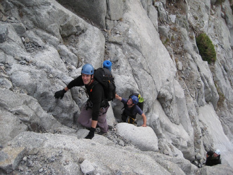
From the base of the second gully after the end of the climber's trail from Stuart Pass, we ascended to the top on pleasant 2nd and 3rd class granite (though not nearly as nice as the Twin Sisters!). At the top of this gully, we made an ascending traverse to climber's right into a second gully and took this towards Long John Tower. Here the climbing turned to solid 4th class with some exposure for a few moves, before easy back to 3rd. We reached the notch behind Long John Tower around 11:15 (?). We found our route to be quite manageable and passed to the left of the tower in the right-most of the two obvious options from the ground. Looking at other route descriptions, this is described as fourth class. The left gully involves a bit of low 5th.
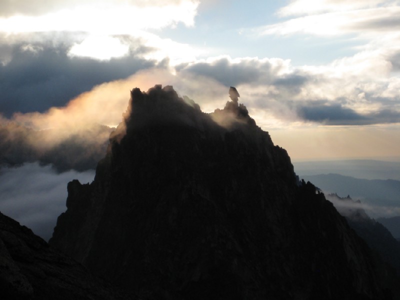
Unfortunately, the clouds which had been predicted to break were still in full force and visibility was quite limited. We turned right, trying to follow route beta which suggested descending 200-300 feet on easy sandy ledges to meet up with the next gully system. We could see easy sandy ledges about 200-300' below us, but getting to them was far from easy. First we tried a level traverse, which led to some low 5th slab climbing and a blank wall of whiteness, then a descent which involved some 4th/low 5th downclimbing. Finally on the sandy ledges, we traversed right, reached a notch where we ate lunch, continued traversing and eventually found a place to drop in to the gully system we'd been looking for. As we ascended, I experienced an odd feeling of deja-vu as we scrambled around a granite cleaver in the gully lodged with loose looking chockstones. Reaching the top of the gully, we looked for the West Ridge Tower and Ethan exclaimed, "We've bee here before!" Obadiah and I initially exclaimed, "No fucking way, we did not just walk in a fucking circle," but Kris's GPS track and Ethan's photographic evidence confirmed it. Disoriented by the fog, we had assumed we were on the north side of the ridge and interpreted "east" in the route description as "right". We had just burned an hour an a half circumnavigating Long John Tower (and nearly climbing to its summit).
At this point, the weather cleared sufficiently for us to see the West Ridge Tower to our east, with a route towards it consisting of easy sandy ledges. We descended about 100' and crossed into the gully beneath the West Ridge Tower. Easy scrambling brought us to the top (to climber's left of the West Ridge Tower). Here a wide traversed the south side about 200' below the top. This ended at some easy but exposed 4th class, which we roped up for (40', easily protected, don't bother with climbing shoes). From here, we got our first view of the summit block, which looked mighty impressive.
To reach the summit, we descended ~200-300', aiming for an easy crossing a rib about 30' below an anvil-shaped rock. This put us in a loose, but easy gully that led directly to the West Ridge Notch. With the time now standing at 2:30, we were hopeful that we might still get over and down the Cascadian Couloir before full darkness.
We scrambled up from the West Ridge Notch on easy 3rd and low 4th to a wide ledge beneath a steep face. On our left was a ramp leading to the north side of the peak and on our right a ledge leading towards the south face. Here, we chose to use the right trending ramp and then climb back to the north across the top of the face, which, while probably not the correct route, involved some fun mid-5th moves. At this point, the clouds rolled back in, obscuring visibility and chilling us considerably. We got back "on route" above this, reaching a "tiny notch" and descending easy low 4th blacks to a long, sandy ledge with a few bivy sites on the south side of the peak. I believe this is the point where Beckey indicates a 5.4 chimney or 5.6 layback crack to the summit. We found neither and burned quite a bit of time on dead ends before climbing something 5.funky, which exited onto blocky terrain with huge rope drag and a wide chimney jammed with two chockstones. On top of this, we climbed to climber's left on to the north face (involving a cool bear hug of a large bulge) and on to easy fractured 4th class to gain the summit proper.
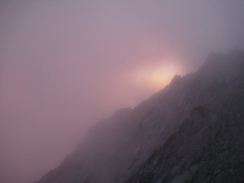
By the time Kris and I joined Ethan and Obadiah on the summit, it was nearly 6:45 and we didn't begin our descent until 7:30. Realizing we would not make the Cascadian before dark and worried about route finding in the thick clouds (now breaking up to the north), we elected to bivy at the first feasible location - a pair of broad, sandy ledges about 200' below the summit just to the south of the ridge crest. From here, we watched the clouds break up to the north for a spectacular sunset over the Enchantments and then, eventually, to the south as we settled in for a cold night. Ethan was able to capture some great images of "sick alpine light" which made the bivy worthwhile for him.
[begin shameless plug for Feathered Friends] I had a Verio bag (1 lb) and a Volant jacket and spent the night in relative warmth and comfort, padded from the ground by the frame sheet of my pack and a flattened out rope. Probably slept for 6+ hours and never felt really cold. Ethan and Kris had warmer leg layers and spent the night in moderate, damp warmth within their bivy sacks. Obadiah did a lot of push ups. [end shameless plug for Feathered Friends]
We got underway on Sunday morning around 6am, dismayed to find clouds once again engulfing Stuart. However, we were able to follow cairns and boot tracks along the ridge line, eventually crossing to the north side of the peak to bypass a south trending rock rib. (In speaking with Jim after the trip, our conclusion is that descending before crossing this rib puts you in Ulrich's Couloir. Jim, now itching to try the Cascadian descent is keen to get back on Stuart). Here, we scrambled some loose 3rd class to avoid a bulletproof snowfield, went through a very cool tunnel, and then descended some highly mobile 2nd class talus to a relative saddle. Here, the clouds finally began to break and we were able to orient ourselves with respect to the Enchantments (Sherpa was particularly striking with clouds spilling over the summit crest and around the balanced rock).
[begin rant about people ranting about the Cascadian Couloir] Having heard horror stories about the Cascadian, we kept preparing for things to get really steep and nasty. What we found instead was a very pleasant descent to 7800' on a sandy track, a 100 yard traverse across some loose talus, a nice walk through some scrub forest at the head of the gully, and then a clearly defined sandy track winding down. Continuing strait down the broad gully (without traversing out of it to skiers right between 7600' and 8000') is what I believe Beckey refers to as "Variation No. 1". At a handful of points, we made use of our hands, but for the most part it was a downhill walk on a beach. We were ready for it to be over by the time we reached the bottom, but I would never describe our route as unpleasant. I do, however, think you would have to be clinically insane to go up it this time of year (as we saw several parties doing on Sunday morning). We exited on a dirt boot track through some shrubbery (too nice to be considered brush), descended some grassy slopes, and stepped on to the trail at the bottom of the valley at 4800'. Either my sense of what constitutes nasty was way off from our little "jaunt" around Long John Tower, or most of the people who rant about how terrible the Cascadian is on the way down have actually descended Ulrich's Couloir. The Cascadian is as miserable a way off Stuart as the Goodell Creek approach to West Mac is a heinous bushwhack. [end rant about people ranting about the Cascadian Couloir]
From here, it was just a matter of hoofing it out. We refilled on water at a creek crossing and then made short work of the climb back of Long's Pass with Ethan setting a blistering pace. Then easy on the knees downhill back to the parking lot, arriving at the car around 11:30. We were particularly happy to discover that the beers and watermelon stashed in the car were still cool from the previous night and ate and drank with gusto.
Many thanks to a great party who never got bent out of shape, despite what we managed to inflict on ourselves. As someone said, "Maybe checking a compass in a whiteout isn't such a bad idea."
Kris's GPS track says 15.something miles RT and 9316' gain (an even 100' short of Stuart's elevation).
Obadiah and Ethan Scramble
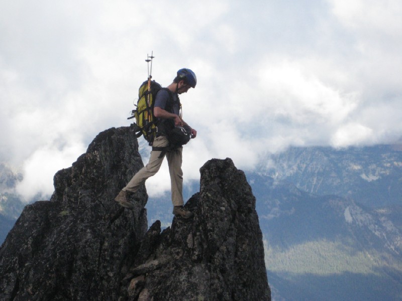
Ethan getting ready to shoot
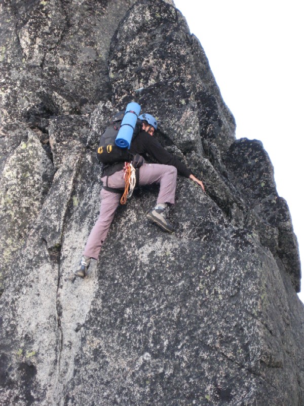
Obadiah goes the hard way
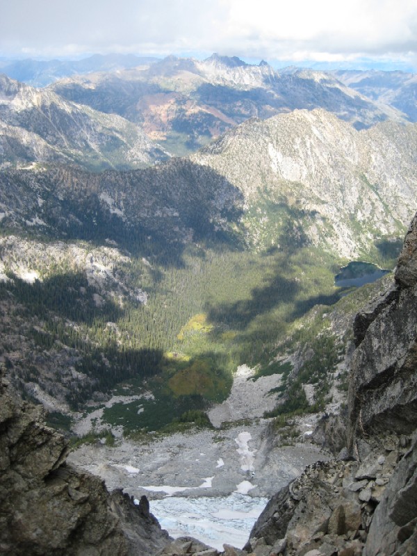
Stuart Glacier
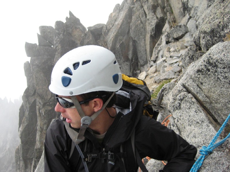
Brian at the belay
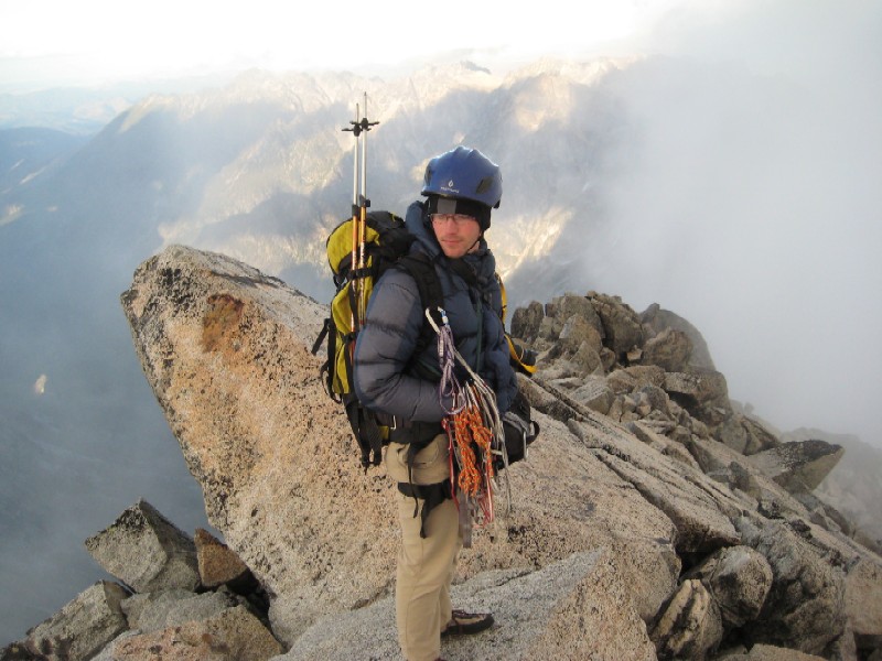
Ethan on Top
Fading light
Sherpa in the Morning