Downtown Minneapolis Personal Rapid Transit (PRT) Network Concept
Prepared by former Minneapolis Council Member Dean Zimmermann
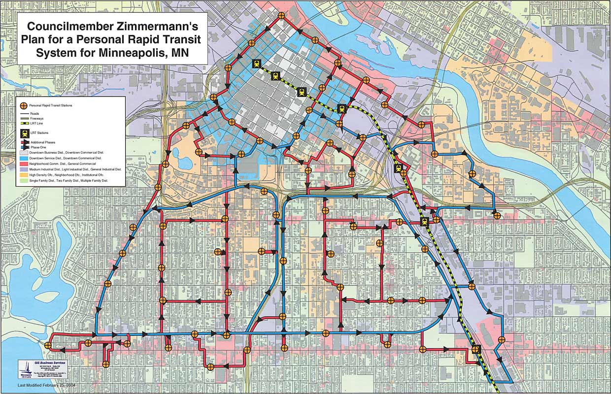
Zimmerman's concept plan is a 68-station PRT system that serves downtown Minneapolis and some high density housing areas to the south. This PRT network includes the highest density housing areas in the State of Minnesota.He designed the PRT network and overlaid it on a base land use map from the City's mapping department. The City staff were very helpful in showing him how to use the mapping technology and provided him with the base map and a work station to develop it -- and lots of helpful advice as he proceeded. This work was done in 2004.
Note that the map has loops of two colors. The three large blue loops are the base or foundation loops. They are considered to be essential. The red loops are possible extensions. Any of them can be removed without causing problems in other parts of the network. His idea was to build the blue loops first and then add the red loops later. If there was resistance from certain neighborhoods, they could be bypassed until they decide they want to be included. The blue loops tend to follow freeways and very major streets, thus minimizing visual intrusion objections from residential neighborhoods.No detailed cost estimates were prepared in 2004 (or since). This PRT network has about 32 miles of guideway and PRT system costs in 2010 are likely to be about $15 - $20 million/mile, If so, the cost of the full system would be approximately $480 - $640 million, and could well be more than that, depending on the selection of a PRT technology and a number of other variables that are difficult to predict. Also, no estimates of the likely ridership
of this concept were (or have been) prepared.
PRT Station locations:
Public Housing locations:A station is located in or at every Public Housing high rise in the PRT service area
Intermodal transportation connection locations:
Stations are located in or at four (4) Hiawatha Light Rail Stations This Light Rail Line serves
Minnehaha Falls, the Airport and the Mall of America
A station is located at the North Star Commuter Terminal.
Stations are located in or at five (5) Commuter Bus Terminals.
Near the Greyhound Bus Terminal
The PRT network is crossed by almost all city bus routes serving the Minneapolis half of the metro area.
Stations at Three Major Hospitals,:
Fairview-University, Abbot-Northwestern and Hennepin County Medical Center
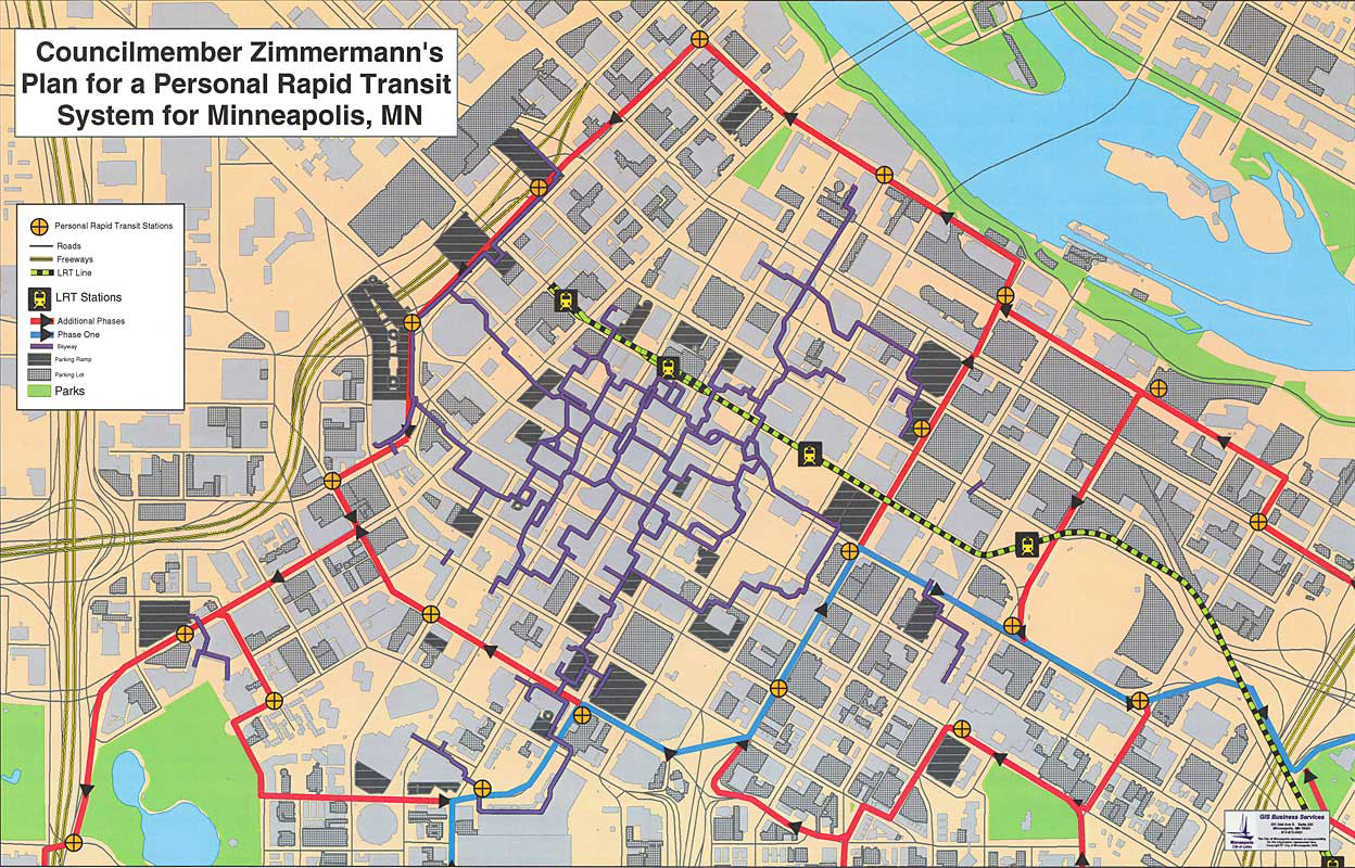
Connections to the Downtown Skyway System:Six stations provide connections to the extensive Downtown Skyway System, located on the perimeter of the PRT network (see second map below).
Stations at Major Employers:
The Midtown Global Market
Wells Fargo Headquarters
The Convention Center
University of Minnesota
Downtown Skyway District (Extensive elevated Skyway for walking in hot or cold weather is shown in purple on downtown map, below).
Grocery store stations:A station is located in the parking lot of every major grocery store in the PRT service area.
Major Destination Stations:
Target Center
Target Field (baseball)
Guthrie Theatre
Minneapolis Institute of Art
The Metrodome (football)
Walker Art Center
Sculpture Garden
St Anthony Falls/ historic Mississippi River Front Area / Mill City Museum
Major Education Facility stations:
University of Minnesota (two stations) on West Bank Campus / link to the free U of M shuttle busses.
MCTC (Mpls Community Technical College) and Metro State University
Augsburg College
St Thomas University
Dunwoody Institute
Other connection attributes:
Eat Street, Neighborhood Business Intersections and Maria's Cafe
A station is less than 3/8 of a mile from the homes of 99.5% of all 85,000 residents of the PRT service area
The PRT system will allow each and every parking ramp in the PRT service area to serve all other stations in the network
The PRT system will give downtown residents pedestrian access to all grocery stores and other neighborhood shopping destinations in the PRT service area.
The PRT system will give Convention Center visitors 24/7 access to:
The Mississippi Riverfront
City Lakes
Eat Street, the Hennepin Avenue Theatre District
The Warehouse Entertainment District
The West Bank Entertainment District
The PRT Web is designed to be expandable just by adding more guideway loops and stations into more neighborhoods.
The term "network" is used to describe a system of interconnected guideway loops. This is a significant difference from a bus line or a rail line which is basically a service system which only provides access to a few intermediate locations between its origin and end-of-route destination. In a PRT system, a PRT vehicle can move, non-stop, from its origin station to any other station in the network, taking the most direct route. For a 68-station network, 4,556 origin-to-destination trips are possible, far more than can be provided by concentional bus and rail systems.
Comments or questions can be directed to the author:
Dean Zimmermann deanzimm@comcast.net 612-207-1319
Last modified: August 18, 2010