Suburban Silver Bullet: PRT Shuttle + Wireless Commute Assistant Using Cellular Location Tracking
by Steve Raney
April, 2004
Abstract
In a hypothetical Year 2008 scenario, a personal rapid transit (PRT) circulator "shuttle" system and comprehensive door to door "new mobility" service transforms Palo Alto's major employment center into a transit village of two square miles, complementing and significantly increasing the attractiveness of commuter rail, carpool, vanpool, bicycle, and bus commutes for the center's 20,000 employees. Of utmost importance, PRT provides faster service than driving alone for the "last mile." A Transportation Management Association enables a supportive commuting culture. A larger candidate pool accesses the personal "MatchRide" web-based ridematching service, increasing carpool formation.
Proposed are new applications of cellular location tracking technology and Wi-Fi (802.11) enabled handsets to increase the competitiveness of suburban commute alternatives. Cellular phones evolve to become a commuter's "command center", an integral part of the workday. The following applications are proposed: A) "TrakRide" to improve the reliability of carpool rendezvous and increase courteous, punctual behavior. B) "NextTrain" to improve the reliability of train-shuttle connections. C) "HomeSafe" to verify that carpools amongst strangers operate safely. D) "QuickCar" to provide five-minute access to cars for centralized car sharing and emergency ride home, using "wireless door key." E) "SpyKids" to maintain secure custody of children during unaccompanied shuttle trips. F) "NextSpace" to direct commuters to available parking spaces, with wireless access to automated, shared parking lots. A central database, known as "Big Sister," maintains personal data to support these applications.
INTRODUCTION
This new concept proposal concerns how to remove a significant number of cars from job-rich suburbs. In the San Francisco Bay Area, suburban office park commute mode is roughly divided as follows: 78% drive alone, 16% shared ride, and 3% transit. (1) Removing cars allows for the reclamation of parking lots for more productive use, enabling densification and intensification of land use. Numerous additional benefits accrue from removing cars: reduced traffic congestion, air pollution, and toxic runoff.
For suburban job centers with 20,000 or more employees and 100 or more buildings spread over one or more square miles, the effectiveness of the proposed wireless commute assistant coupled with a very high level-of-service PRT shuttle was validated (and iteratively refined) through 13 one hour interviews and 62 in-depth surveys of technology workers. When survey subjects were presented with this hypothetical commute alternative, drive alone commute mode share dropped from the current 89% down to 45%. The time penalty for taking a commute alternative door to door versus driving alone was typically 30% or less, in other words, given a 20-minute drive alone commute or a 26- minute commute alternative, workers regularly chose the alternative. Pertinent interview comments are interspersed in this paper. (2)
Proposed is a 20-station personal rapid transit (PRT) "shuttle" system for Palo Alto's Stanford Research Park (SRP) major employment center, complementing and significantly increasing the attractiveness of commuter rail, carpool, vanpool, bicycle, and bus commutes. PRT provides elevated, electric, demand-responsive, non-stop, medium capacity, no-wait, 30 mph service for the commute's last two miles, and services mid-day trips. In addition to PRT, the proposal includes a very comprehensive "door to door mobility" service, called "D2D," that supplies both high tech (web/cellular) and "high touch" (personal) solutions to meet workers' complex transportation needs. D2D includes solutions to improve carpool and transit connections, increase the safety of carpooling with strangers, rapid car share/emergency ride home, and improved carpool matchmaking.
An economic analysis, methodological description, and smart parking design are provided in a related report by the author. (2)
Stanford Research Park
Stanford Research Park (SRP), located in Palo Alto, California, is counted among the world’s leading major employment centers. The 1,000-acre park includes 161 buildings serving 160 companies. For this paper, SRP is expanded to include twelve adjacent blocks of convenient retail, and a Caltrain commuter rail station. SRP experiences significant traffic congestion. All new development projects require significant traffic mitigation.
Santa Clara County alone boasts 11 other major job centers. For the country as a whole, Joel Garreau defines suburban edge cities as having 5M square feet of office plus significant retail, and identifies 185 such cities that are larger than Memphis. (3) Should the transformative model for SRP work, then it may spread rapidly throughout these U.S. edge cities.
SRP Commute shed
A "commute shed" is a GIS plot of home originations for the journey to work to a particular location. 47% of employees live with a 2-mile radius of a connecting commuter rail station. In addition, 28% of workers live within a five-mile radius and 49% live within a ten-mile radius of SRP. (4)
PRT: rapid local shuttle Alignment
Personal Rapid Transit (PRT) is being actively developed by three companies, Skyweb Express, Advanced Transport Systems, and MegaRail. All three have test tracks with at least one vehicle and all are at least two years away from commercial operation.
The five-mile PRT shuttle system consists of approximately 300 lightweight, driverless, three-person electric vehicles traveling on elevated "rail" 16' above the ground. Transit stations are located near building entrances. Frequent stations are situated along the route to minimize walking once the trip ends. Station guideway is separated from the main track - vehicles turn off onto a siding to pick up and drop off passengers. Because of these turn-offs, vehicles travel non-stop to the destination at 30 mph, bypassing intermediate stops and speeding at twice the average speed of autos on the congested SRP roads below.
Vehicle weight minimization greatly reduces the size of the elevated rail and supporting columns, dramatically reducing construction cost and right of way acquisition. Vehicles flow through the rail somewhat like data packets on the Internet, anticipating demand so that wait time is eliminated. In addition to improving commute alternatives, the PRT shuttle eliminates mid-day stranding caused by many commute alternatives, by providing efficient transit to adjoining shops and restaurants.
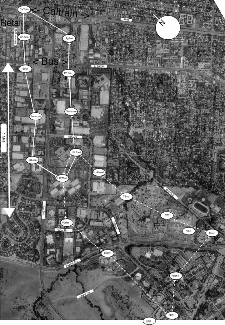
A 20-station shuttle system is shown in Figure 1 below. Highway 101 lies above the map to the northeast and Highway 280 below to the southwest. The Caltrain station is in the upper left corner, adjacent to "California Avenue" retail. The system consists of a one-way "figure 8", with a distance-reducing "shortcut" located in the middle portion of the 8, connecting "HP East" and "HP West." The bottom loop resides on a hill that presents a strenuous challenge to bike riders. There are very few sidewalks within SRP, but many connecting parking lots.
A new methodology has been developed for collecting fine-grained employee commute origination data from employers in major employment centers. Many U.S. multinational firms have adopted the European Parliament Privacy Directive 95/46/EC, the strictest privacy law to date. The methodology discussed complies with this Directive. "Fine-grained" is defined as providing sufficient resolution (approximately 1,000 feet) to assist transportation planning of individual bus stops. Directive 95/46/EC provides for "anonymization" of data to where the data subject is no longer identifiable. Individual address data is aggregated to a 1/5 by 1/5 mile grid at the employer site using commercial geographic information systems software. Once the grid data is taken from employer premises, data is combined with those of other employers, providing further anonymization.
8,200 out of approximately 20,000 worker addresses have been collected from the Stanford Research Park major employment center in Palo Alto, California using this methodology. While the sprawling spatial distribution of these addresses challenges many Transportation Demand Reduction strategies, planned transit system improvements should result in a significant ridership patronage increase.
This methodology could be automated and applied nationally by the U.S. Census Bureau as part of their Transportation Planning Package, creating higher quality transportation data for improved investment decision making, ridesharing, and transit routing.
D2D Mobility - New Mobility TMA
Shaheen defines "new mobility" as "pairing clusters of smart technologies with existing transportation options to create a coordinated, intermodal transportation system that could substitute for the traditional auto." (5)
The "D2D" service will be provided by a Transportation Management Association (TMA) called "D2D Mobility Corporation", where SRP employers join together to manage transportation demand. The formation of the TMA is essential in creating a political entity to negotiate office property easements to accommodate the small right of way requirements of PRT. The powerful TMA is also essential in providing the "supportive policy context" that is crucial to change the suburban drive alone predisposition. (6) SRP's 20,000 workers provide sufficient scale for D2D services to run efficiently. The TMA's motto is envisioned as follows:
We provide you with door-to-door mobility from home to work and back, and errands in-between! We are a partnership of concerned organizations working to make commute alternatives as convenient and flexible as driving alone. Partners include transit agencies; City of Palo Alto; large local employers; and key service providers including a local taxi company, car sharing service, a rental car firm, bicycle coalition, and ridesharing agency. Additional partners deliver groceries, meals, dry cleaning, and photos, to name but a few. (2)
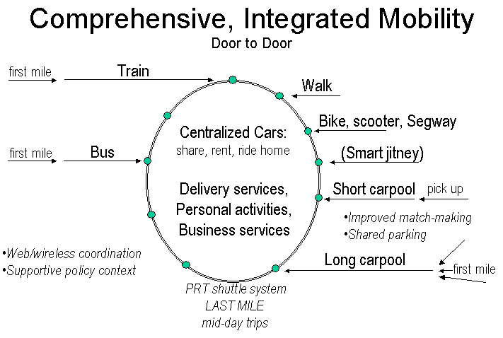
Comprehensive, integrated mobility
Suburban commute alternatives are diagramed in Figure 2 below. The PRT Shuttle solves the "last mile" problem, efficiently connecting different commute alternatives to workplaces. A stylized version of a shuttle system is shown as an oval with many stations blanketing the job center with efficient feeder/distributor service. PRT-centric new mobility is an original concept.
Of particular note, driving alone requires very little conscious thought. People drive alone following their route out of habit, focusing very little of their mental capacity on the driving. To compete with driving alone, commute alternatives must become simpler. The D2D "wireless commute assistant" attempts to take on the burden of making smooth connections, reducing the effort and stress of alternative takers.
Train and bus commuters face the "first mile" problem as well: how to get to the train station or bus stop in their home city. A solution for the last mile (and mid-day stranding) often provides sufficient motivation for commuters to solve the first mile problem.
For commuters living one to three miles from the edge of SRP, the PRT shuttle enables commuting via foot, bicycle, electric bicycle, scooter, and, possibly, by Segway. Palo Alto and its adjacent cities (Menlo Park, Los Altos, and Mountain View) feature attractive, tree-lined residential neighborhoods that are conducive to human-powered commuting. The research park, though attractively landscaped, is a hostile, hilly environment for pedestrians and cyclists. The four and six-lane roads promote auto-dominance, creating a noisy and dangerous environment. The shuttle enables commuting under human power for the enjoyable residential portion of short commutes, switching to PRT to avoid the disagreeable last mile.
Eventually computer-dispatched smart jitneys (commuter vans) may ply suburban collector roads to bring commuters to the edge of SRP for ensuing PRT distribution. Jitneys are especially effective for regularly sweeping through low-density suburban residential corridors and solving the first mile problem. (7)
Carpooling breaks down into two main scenarios with different first-mile concerns. The first is a shorter commute of 4 to 15 miles where the driver picks up a passenger from the same part of town. If there is a rendezvous problem in the morning, then both drivers simply drive alone at their own pace – missing the carpool does not have a large time or convenience impact. The second carpool type is for longer commutes where three people converge on a rendezvous point such as a shopping center parking lot and then share a car from that point.
Carpool members are usually strangers who are matched by MatchRide. Previously, members typically worked at the same company, meaning that finding a carpool partner within reasonable home proximity was a significant challenge. By providing efficient distribution, PRT breaks this restriction. Carpoolers travel to the edge of the employment center, park at the most convenient employer lot, and then ride PRT to reach their workplaces. With 20,000 workers serving as potential carpool matches, the spatial matchmaking probability improves dramatically. Carpooling among friends and family will also experience an increase because of the PRT shuttle.
Survey research showed that the proposed solution concepts were effective in addressing behavioral impediments to carpooling. (2)
By rapidly connecting an entire major employment center, PRT provides sufficient scale for centralized commute services such as "guaranteed ride home", car sharing (including station car programs), and car rental.
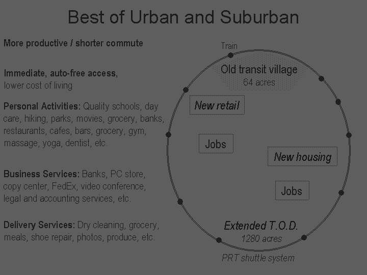
Best of Urban and Suburban
In mixed-use Central Business Districts, jobs, housing, and shops are all within convenient walking distance. In many suburbs, only an auto can provide an effective link between these three main real-estate uses. The PRT shuttle offers the promise of making these uses more rapidly accessible than via auto. The concept of the extended transit oriented development was first introduced by Schneider. (8)
While not representing the ideal "New Urbanist" transit village, the proposed remedy for an existing suburban office park will create a very lively environment to work and live in. New high density in-fill housing for SRP workers inside the research park could reduce the jobs/housing imbalance, reduce long commutes, and provide a rich set of personal and business services, including top ranked public schools and hiking trails.
A typical transit village, as defined by Peter Calthorpe, is a half-circle of radius 1,000 feet emanating from a rail station, an insignificant blip amidst low density suburbia. (9) PRT+D2D creates a "walkable" area 20 times the size.
D2D new mobility: high touch features
High touch (personal) solutions consist of customer support, commute coordinators, commute community, and MatchRide.
Customer Support
Interviews indicated there is a lurking fear of being stuck in the middle of a trip. In reaction to this concern, D2D customer phone support should serve as a "guaranteed backup." Rather than the commuter being responsible for resolving problematic situations, D2D promises to get commuters to their destinations, serving as the last line of defense.
Neighborhood Commute Coordinators
Reducing drive alone commutes is a battle won one person at a time, addressing specific individual objections. A network of volunteer neighborhood commute coordinators is necessary to provide hand-holding, support, and local expertise to technology workers. The coordinators should have the following attributes: highly persuasive, upbeat and encouraging, creative problem solver, a "green" mentality, effective advocate, and good communication skills. They should serve as: A) the best resource to go to for commute alternatives to SRP and B) a collector and prioritizer of local barriers to be overcome. Their most important service will be guiding technology workers through the first two weeks of a commute alternative (akin to detox), providing follow-up and encouragement.
Web-based Commuting Community
Another high-touch tactic creates a web-based commuting community for support, information, and problem solving. For a drive alone technology worker to switch, that person needs to become a commute problem-solving expert, which probably isn’t worth an individual’s time. However, a web community can share expertise, reducing individuals' learning curves. Chat forums based on city of residence and major knowledge areas will be provided, with neighborhood coordinators monitoring. The knowledge base will efficiently address repetitive issues related to comfort, gadgets, behavior, and local context.
MatchRide: Improved Ridesharing Matchmaking
The Bay Area's current carpool matchmaking service (provided by RIDES.ORG) provides too little information (and no personal information) to make an informed decision. More personal models are plentiful at numerous web dating services, providing more rich textual detail combined with photos. For carpool matching, a facial photo and an auto photo should be combined with a rich personal profile. These services allow prospects to anonymously reject bad matches without causing any hurt feelings.
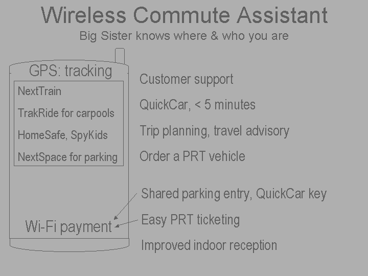
Wireless Commute Assistant
Cellular telephony is experiencing accelerating innovation. Cellular telephony has been described as a major technology poised to generate many new jobs. There are 1.2 billion cell phones, one for every 5 people on the planet. By 2006, there will be 2.0 billion cell phones. One-third of all cell phone users upgrade to a new handset every year. High data bandwidth cellular technology is on the horizon, known respectively as "3G" and "4G." The latest handsets are adding personal digital assistant features. Computing power is increasing, reaching ever closer to becoming a "personal computer in your hand." New hardware such as GPS and WiFi (IEEE 802.11 wireless communications) is being added. (10)
The applications are explained in subsequent sections. These are preliminary descriptions of applications that have not yet been developed, but appear to be relatively straightforward to implement.
Big Sister Database
To best serve finicky tech workers, personal information databases must be created and commuter whereabouts must be tracked (using cellular "geolocation" technology). One interviewee reacted negatively to this tracking, saying it was reminiscent of "Big Brother." So, regrettably, we must define a new term to position this effort against Big Brother. Whereas in Orwell’s book, "1984," Big Brother tracked personal information to reduce personal liberty, "Big Sister," uses modern technology to preserve Mother Nature. Big Sister has a gentle hand, but knows when to be nosy to be of assistance to commuters. Big Sister increases commuter safety with her ability to verify that someone reached their destination, especially when a carpool with strangers is involved. Associated databases and software applications must be designed to be both interoperable and secure. Other respondents were enthusiastic about the tracking. Another interviewee felt, "a service that tracks you would be fine." As an aside, RIDES, the Bay Area's central ridesharing service, keeps no information on carpools once they’re formed.
Privacy Concerns
Privacy concerns abound for Big Sister. For protection, this service must be "opt-in" with independently run data protection audits and a consent requirement for each new use of personal data.
Cellular Location Based Services for Tracking
This section introduces cellular Location Based Services technology, which is used in many of the D2D cellular applications.
A Federal Communications Commission mandate has forced all cellular carriers to provide emergency services that determine cell phone location. As part of fulfilling this "E-9-1-1" requirement, carriers will make geolocation software interfaces ("GPS-1", "J2ME MIDP 2.0") available to application providers. The FCC mandates location accuracy of 100 meters for 95% of cell phone calls by 2005.
Location is determined with trilateration algorithms where the handset collects and processes signals from GPS satellites and/or cellular base stations. There are many techniques to determine location, providing tradeoffs among important attributes. Key attributes include "time to first fix," availability, accuracy, cellular network bandwidth required, handset cost burden, and base station cost burden, with the first four attributes carrying the most importance for tracking applications and the later two having a strong impact on the rate of adoption. A small time to first fix, the startup time to calculate the first position, is desirable for tracking applications where a commuter's position must be determined immediately after application initialization. Some rudimentary GPS solutions require a large startup time, taking several minutes to provide a position fix. Availability measures whether or not a location can be determined. Availability in indoor settings, where signal strength is lower, is important for commuter tracking applications. Accuracy measures the distribution of calculated locations against true locations. The distribution of positional errors in X and Y dimensions typically comprises an elliptical pattern. For tracking applications, the relative accuracy amongst successive fixes is important. Most cellular location solutions require new cellular handsets featuring new chipsets and antennae. Users of GPS tracking applications should expect to pay $150 for a GPS-enabled handset and $15 per month for data communications services.
GPS Problems
Basic GPS technology isn't well suited for cellular location based services. Aside from the aforementioned problem with slow time to first fix, GPS requires unimpeded "line of sight" access from satellites to the handset, creating problems when handsets are indoors in residential areas and in urban downtowns with tall buildings (urban canyons).
Recent innovations have reduced the power consumption of GPS chipsets and improved the processing power within the handset. Some former solutions had required raw GPS data collected at the handset to be sent to a carrier's server for processing into longitude/latitude. Because tracking applications request location frequently, high communications bandwidth overhead cannot be tolerated.
Hybrid Assisted GPS
One of most promising techniques for tracking applications is called Hybrid Assisted GPS/Cellular Ranging. The solution provides first position fix in a maximum of 12 seconds (1 second in a line of sight outdoor environment). Availability is high within indoor settings. Accuracy is 30 meters indoors and 5 meters outdoors. A "location server" assists the handset's GPS calculation by sending intermediate calculations to the handset, reducing the handset's required GPS signal strength and processing power. Hybrid means the solution combines GPS and cellular base station measurements to calculate location, further increasing accuracy and availability. Once an initial position fix is calculated, the handset is self-tracking and does not require location server assistance. (11)(12)
Software Development Issues
Handset operating systems are less capable than those of personal computers. Tracking and voice operations may be mutually exclusive.
Hardware platforms are incompatible, but the move towards Java may alleviate this.
Data communication latency varies from carrier to carrier and slows during peak time.
Distributing applications to cellular customers is difficult.
Better in-office reception
The additional challenge in cellular geolocation tracking applications is that the cellular data network must have high availability within business campuses, requiring small cellular base stations to improve signal quality. Such base stations are readily available and used in offices already, but they are not yet pervasive. Part of the motivation is to replace wired business phones with cell phones.
Another approach to improving indoor cellular telephony uses WiFi enabled phones. These phones switch from cellular to WiFi for voice/data communications within corporations with specially configured WiFi networks.
TrakRide
The first commute tracking application serves carpools, and is known as TrakRide. TrackRide is a virtual (automated) carpool coordinator who helps make things run more smoothly, reliably, and precisely while off-loading some time-consuming tasks. The assistant provides two-way communication via cellular Short Message Service (SMS) and the Web. Many features are implemented with single click operations.
Benefits
The main benefits provided are increased commute reliability, considerateness, safety, and time utilization.
TrakRide serves as a "security blanket" for carpoolers, who typically encounter a major carpooling problem every 2 months, and a minor irritant about once per week. Even with this intermittent problem pattern, the assistant is always alert and immediately available to solve problems and provide information when something goes wrong. A previously independent drive alone commuter, who switches to carpooling, finds herself dependent on her carpool partners of uncertain reliability. TrakRide removes this uncertainty, making the carpooling experience more palatable to switchers. TrakRide provides a frequently updated graphical depiction of the status of the partners, somewhat analogous to bus stop "time to next bus" displays.
In carpooling, being on time at the pickup spot is the considerate thing to do. TrakRide monitors progress to the pickup spot, graphically highlighting laggards with red dots on-route. Thus, positive and negative performance feedback is glaringly apparent, naturally generating increased social pressure to be punctual. TrakRide also tracks performance over time and can tag laggards for automatic reminders to get them going a few minutes early.
Without TrakRide, improving punctuality often requires personal confrontation. Some existing carpools implement a "5 minutes late cut-off rule." In the morning, if a carpooler is 5 minutes late to the rendezvous spot, other members leave without the laggard. TrakRide provides a gentler method to encourage courteousness by providing a standardized, impersonal measuring system.
In addition, TrakRide facilitates the considerate action of informing other members that the carpool will be delayed a certain number of minutes. TrakRide reduces an individual's ability to make up excuses for tardiness. Says one potential user, "I don't need a reminder to leave. I only need confirmation that others are moving reliably towards the carpool meeting point. One of my carpool members needs special nudging about once every 10 days."
Time utilization is an issue at the end of the workday, before the evening pickup. TrakRide will also track the end of day race to the meeting point, which will require PRT Shuttle trip tracking / scheduling, like NextTrain. Says a second potential user, "Making things a little smoother would be great. If I knew someone was running even a few minutes behind, and I’m in the middle of something, then that few minutes would buy me enough time to finish what I’m doing, rather than thinking ‘Oh Gosh I have to shut down because I don’t want someone to wait.’" The benefit is in knowing exactly when to shut down and reducing stress in wondering whether everyone else is shutting down.
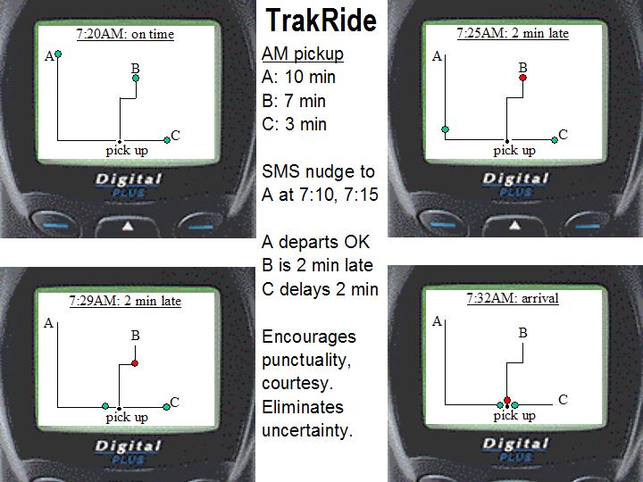
On-route commuter tracking example
Three carpoolers called A, B, and C carpool with a one-way travel distance of about 30 miles. For the morning pickup, all three drive alone to a shopping center parking lot and then carpool from there. A, B, and C are in a daily race against time to get to the meeting point on time. Person A drives 10 minutes to the shopping center, B drives 7 minutes, and C drives 3 minutes. Scheduled pickup time at the shopping center is 7:30AM. Person A needs to leave her home at 7:20AM. She has a history of being late, so TrakRide sends reminder SMS messages at 7:10 and 7:15AM to nudge her to her car.
The cellular handset graphical user interface is shown in Figure 3 below, showing "snapshots" at 7:20, 7:25, 7:29, and 7:32AM. Person A departs on time, but B departs 2 minutes late.
The handset display shows the previous paths that A, B, and C have taken to access the pickup point. A, B, and C all see the same display as the pickup process progresses. At 7:20, all three are on time, at home, and A is ready to depart.
At 7:25, B is still at home, even though he should have left at 7:23, so his dot his shown in red to indicate tardiness, and the carpool is shown as being 2 minutes late. A's progress towards the shopping center is apparent.
C should normally depart at 7:27, but C sees that the carpool is 2 minutes late and has another cup of coffee. At 7:29, C departs. A and B have made progress and B is still depicted as tardy.
At 7:32AM, everyone has arrived at the meeting point.
The handset display shows progress towards the meeting point, a simple process of converting GPS longitude/latitude into display coordinates.
Initially, TrakRide will sometimes induce excessive speeds as tardy members attempt to reduce their lateness, turning their red dot to green. Likewise, there will be times when a punctual commuter departs home at the appropriate time, only to encounter traffic delays that make them late. These unlucky, yet courteous, commuters should receive a "punctual" score for that trip, even though they arrive late.
The trip duration parameter (10, 7, and 3 minutes in the example) may be adjusted based on historical results or by individual commuters via the web. This parameter data is stored by Big Sister, and retrieved daily by the TrakRide application server.
Additional TrakRide Features
Customized traffic advisory. A customized advisory provides relevant data only when necessary: advance notes of traffic generating special events and accident reports specific to the car’s current location and route. Starting just before the first morning departure, TrakRide will check traffic on the carpool's route to work, identifying incidents that may create a high impact on the commute. Where a highway is closed and attractive alternate routes do not exist, TrakRide may offer the following three options: a) a web chat so carpool members can determine how to proceed, b) delay carpool in 15 minute chunks until traffic improves and automatically inform managers of the delay, and c) a voice conference call to allow members to decide how to proceed.
When a member expects to be late, reschedule/delay carpool by X minutes. TrakRide provides easy, reliable communications with other carpool members. With a 3 or 4 person carpool, the logistics of manually contacting each member to delay the carpool by 5 minutes requires significant effort, especially if people are hard to reach. TrakRide automates this process, and can even request an SMS receipt indicating that the member has read the message. A prospective user advises, "A single click or phone sequence that I could dial that could broadcast a message, retry as needed, and confirm receipt would be a good thing." Members may also indicate "go without me today."
Tight integration with guaranteed ride home / car loaner services to provide a convenient way home in the evening when the carpool is missed.
Gentle reminders via SMS. Commuters may choose how to set their handset to react when an SMS message arrives, such as by vibrating. Commuters can schedule their own helpful reminders. TrakRide will also automatically schedule reminders for habitually tardy performers.
Easy connection to human customer support. Support will have each commuter's current location and personal commuting context information available during telephone support calls.
NextTrain
NextTrain tracks a "race" between a train and a commuter to a meeting point at the local commuter rail station. In this race, the commuter should always win with some time to spare.
Example
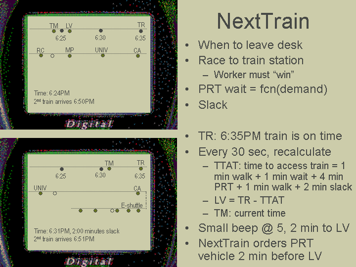
Consider, for example, a commuter attempting to catch a 6:35PM commuter rail train home. The train is on time. The commuter works in the research park. Her desk is a one-minute walk from a PRT Shuttle station.
Once per minute, the commuter's NextTrain handset application queries the NextTrain application server for the train's predicted arrival time at the Caltrain station. This parameter is called "TR" for Train. The NextTrain application server in turn receives frequent updates from Caltrain's train location server. For purposes of this example, TR is 6:35 PM, meaning the train is on schedule.
The time for the commuter to travel from desk to the train station is called "TTAT" for Time To Access Train. This parameter varies for commuters at different locations throughout the research park, in this example the time is calculated as the sum of:
1 minute to walk from desk to PRT station
1 minute wait at the shuttle station to wait for and enter a vehicle
4 minute PRT trip from the office station to one of the two CA Avenue PRT stations
1 minute to exit the PRT vehicle, walk to the train, and enter the train
2 minutes of "slack" in anticipation that something might take longer,
for a TTAT of 9 minutes. The one-minute PRT wait above will actually be a dynamic calculation based on current and anticipated demand around the time of departure.
The time for a commuter to leave from their desk for home is called "LV", for Leave. LV is calculated as TR – TTAT. In this example, we have 6:35 – 9 minutes = 6:26.
For this example, the commuter will have set up NextTrain to cause her cellular handset to play a single tone at five and then two minutes to LV. NextTrain will check whether sufficient PRT vehicles are available at the origination station at time [LV minus four minutes], understanding current status of demand at that station. Should there be a vehicle deficit, NextTrain will order a PRT vehicle to be sent to that station.
In the unlikely case where the commuter leaves as directed, but still misses her train, NextTrain will ensure that she gets home as conveniently as possible, and will provide compensation, such as a free lunch or a few free PRT trips. Before switching to a commute alternative, solo drive never even had a connection to miss. But missed trains could cause a switcher to revert back to driving alone, so customer support should take such incidents very seriously. Commute tracking can evolve to instantly identify customers missing connections.
For the morning connection to commuter rail, one prospective user also has a race against the train to the train station, "If I got notifications that the train was late, this would allow me to stay inside my house. I don't need a reminder when things are going well, but I do need to know when things are out of sync."
QUICKCAR: CAR LOANERS, CAR SHARING / EMERGENCY RIDE HOME
With D2D, separate programs for corporate loaner cars, car sharing, car rental, and corporate/government emergency ride home all merge into a single, centralized service with 20,000 potential customers. Cars will be stored at two locations near the top and bottom tips of the PRT alignment, allowing ignition turning of a loaner car within five-minutes of ordering from any location within SRP. Centralized programs provide scale economies by requiring fewer cars with less management overhead. The central loaner program also provides mid-day auto availability for business meetings and urgent trips home to care for a sick child.
Guaranteed ride home – Some interviewees asked to be switched to another carpool with open seats for the anomalous ride home, when a connection to the standard carpool cannot be made. Respondents desired access to higher speed HOV lanes even in unusual situations. A variant of the typical "missed my ride" scenario is when a company shuts down early because of a facilities problem or an unusual holiday schedule. There exists a similar need to borrow a rider from other carpools to qualify for the HOV lane, providing a combined vision of carpoolers dynamically shifting between cars. TrakRide and MatchRide facilitate development of such a service.
Interviewees felt unsure of how to use corporate emergency ride home loaner program. There were differing understandings of how the program worked: who signed for permission and how much it cost – most would look to other alternatives first. Company-run car loan programs necessarily receive just a few hours of oversight per month. A centrally run program has sufficient scale for strong marketing communications and educational programs, and full-time, dedicated staff.
WiFi enabled cell phones enable effortless, wireless door lock opening. The matching WiFi enabled loaner car polls for a unique WiFi cell phone ID, causing the door to unlock.
Future All-encompassing Wireless Commute Assistant
Over time, all software applications should merge into an all-encompassing wireless commute assistant. Such a Commute Assistant would have the following features:
Be a "smart alarm clock." Rail and bus commuters fear falling asleep and missing their stop. The Commute Assistant can wake commuters when they are three minutes from their train station / bus stop, irregardless of the time. This is preferable to commuters manually setting their watch alarms to beep in a certain number of minutes, as the transit system might be delayed on-route, and their watch would wake them earlier than is desirable.
As part of preventing nightmare commutes, proactively detect when commuters miss connections, then take corrective steps. Don't wait for a call.
"HomeSafe" verifies that a carpooler arrives home safely via geolocation cross checked against scheduled arrival time. HomeSafe may also be optionally configured to ask the commuter for a password upon arrival, providing a second level of protection. When a commuter has not reached home within a certain number of minutes after scheduled arrival, HomeSafe gets into action: a) sends SMS query, "are you OK?", b) eventually calls police. HomeSafe's unnecessary nagging of late commuters who get stuck in traffic is a reassuring feature; Big Sister's concern for commuters in non-threatening situations increases confidence that Big Sister will be there vigilantly when danger lurks. Shaheen's carpool focus groups reveal safety concerns reign supreme. HomeSafe lessens this safety objection.
SpyKids maintains secure custody of children during unaccompanied shuttle trips. Reduces the need for parents to accompany children to destinations served by PRT. The parent authorizes the receiving person (for instance, a day care center worker) to pick up their child at a destination PRT station. The parent puts the child into the PRT vehicle at an origination station. During the PRT ride, the child is in the custody of D2D Mobility. SpyKids will NOT drop the child off at the destination station unless the receiving person, as verified by cell phone WiFi identification, is present. In the case of a missed connection, the child will be re-circulated on the system, either bringing the child back to the parent, re-trying the drop-off, or bringing the child to a safe, monitored location. Parents may track the entire trip. Video feed from PRT stations and vehicles is available during the trip. Voice communications with the child can be undertaken.
Trip planning using a commuter's current location and Big Sister preference data to make smarter selections with less commuter data entry.
Real-time PRT vehicle booking. Allows commuters to request a vehicle from their desk, two minutes before walking to the PRT station platform, increasing the chances of zero wait at the origination station.
NextSpace / Shared, Automated Parking
Most drive-alone commuters will park at their company lot. Carpoolers will enjoy the opportunity to park at the first available lot at the edge of SRP, avoiding traffic within the office park. "NextSpace" will direct carpoolers to available parking lots. Empty parking spaces will tend to fill in first at the edges of SRP.
The TMA will control all parking within SRP, sharing spaces with all companies. The total requirement empty parking space reserve will be reduced as spaces are shared efficiently. Scale economies should reduce annual per-space operations costs. Lots will operate in an automated fashion, via a central parking control facility that also manages parking lot security via surveillance cameras. Much like HomeSafe, cellular location tracking allows automated detection of possible parking lot assaults. Accurate space utilization and availability will be known at all times. Each lot will be gated, with wireless cell phone access providing very rapid gate interaction.
Effortless PRT Shuttle ticketing and destination selection
For many PRT trips, WiFi enabled cell phones with wireless credit card payment can eliminate ticketing and destination selection effort. Cell phones with keypad data entry and graphical displays provide richer capabilities than transit "smart cards."
Because it provides direct point-to-point service, PRT requires the specification of destination station before a vehicle departs a station. The 20 SRP stations may evoke images of a proprietary ticketing mechanism with a "pick a station" touch screen user interface (possibly requiring two screens to navigate). With this mechanism, the commuter would have to struggle to find their payment mechanism and to select their destination every time.
Instead, commuter cell phones can identify a commuter to a fare gate, and Big Sister can retrieve that commuter's trip-making context, suggesting the likely destination station. If no changes are required, this can all occur with no physical effort by the commuter. Thus this very personalized fare gate system reduces transaction time and effort.
The typical fare gate interaction is as follows:
A commuter walks up to an entrance gate at a PRT station with cell phone in brief case or pocket. The gate is constantly polling for commuter cell phones.
The commuter's cell phone announces that a commuter with a unique ID has arrived.
The gate retrieves tripmaking patterns, selects the most likely destination, and displays the information on a computer monitor that is visible to the commuter.
In most cases, the commuter agrees with the suggested destination station and boards the appropriate vehicle. When the commuter prefers another destination, they select it from the display.
Once the vehicle is on-route, the commuter's credit card is debited.
Wireless Payment
The enabling technology is provided by a new series of cell phones. Bluetooth and WiFi (802.11) provide short-distance wireless communications featuring seamless connections and data transfer between devices. Standards groups are currently working to set protocols for credit card settlement.
Individual Trip Making Paterns
Most commuters will only use between three and six of the 20 stations on a regular basis. For example, one commuter might have the following patterns:
If he appears in the proximity of the Caltrain station between 5AM and 11AM, then he is going to go to his job site, "EPRI."
If he appears in the proximity of the EPRI station between 10AM and 2PM, then he'll go to 1 of the following PRT stations: {Agilent (to access a computer store), CA Ave (for lunch), Caltrain (for lunch), BofA (for banking or for lunch)}.
If he appears in the proximity of {Agilent, CA Ave, Caltrain, BofA} between 10AM and 3PM, then he's going to go back to EPRI.
If he appears in the proximity of the EPRI station between 3PM and 7PM, then he's going to Caltrain.
NEXT STEPS
This proposal is undergoing an independent analysis that could result in productive action within the political realm, such as a planning study or larger travel demand analysis. TrakRide and HomeSafe are patent pending and under development.
Acknowledgements
Thanks to Robert Cervero, Forrest Deuth, Jim Galanis, David Maymudes, Rob Means, Jeral Poskey, Jerry Schneider, Susan Shaheen, and Tom Richert.
REFERENCES – (web links Updated March 2004)
1. RIDES.ORG. 2002 Commute Profile. RIDES.ORG. http://rideshare.511.org/research/pdfs/commuteprofile_2002.pdf.
2. Steve Raney. Suburban Silver Bullet: PRT Shuttle + New Mobility Halves Solo Commutes. Masters Thesis, U.C. Berkeley City Planning Department. 2003. http://www.cities21.org/silver_bullet.htm.
3. Joel Garreau. Edge City. Doubleday, New York, 1991.
4. Steve Raney, Privacy-Protecting Commute Shed Study. TRB Proceedings 2003. http://www.cities21.org/CommuteShed_TRB_111502.doc.
5. Susan Shaheen. Dynamics in behavioral adaptation: a case study of Carlink carsharing. PATH report UCB-ITS-PRR-99-41. PATH Program, Berkeley, CA. 1999. http://www.path.berkeley.edu/PATH/Publications/PDF/PRR/99/PRR-99-41.pdf.
6. Deborah Salon, Daniel Sperling, Susan Shaheen, Daniel Sturges. New Mobility: Using Technology To Create More Efficient Transportation. University of California ITS, Davis. 1999.
http://database.path.berkeley.edu/imr/papers/UCD-ITS-RR-99-1.pdf.
7. Y.B. Yim, Asad Khattak. Personalized Demand Responsive Transit Systems. PATH Report UCB-ITS-PWP-2000-22. PATH Program, Berkeley, CA. 2000. http://www.its.berkeley.edu/publications/UCB/2000/PWP/UCB-ITS-PWP-2000-22.pdf.
8. Jerry Schneider. Describing Extended Transit-Oriented Development. http://faculty.washington.edu/jbs/itrans/e-tod.htm.
9. Peter Calthorpe. The Next American Metropolis. Princeton Architectural Press, Princeton, NJ, 1993.
10. Business 2.0 Magazine. The Next Big Thing. Business 2.0 Magazine, July 2003.
11. Norman Krasner, G. Marshall, W. Riley. Position Determination Using Hybrid GPS/Cellphone Ranging, ION GPS-2002 Proceedings, 2002. http://www.snaptrack.com/pdf/ion2002_pos_determination.pdf.