Designing a High Performance PRT Network for an Edge City
by Jerry B. Schneider
Professor Emeritus - Civil & Environmental Engineering
University of Washington, Seattle, WA 98195e-mail: jbs (at)peak(dot)org
Note: Since this paper was written (in 1997), several inventions have appeared that can be used to make PRT stations more accessible. They are personal mobility devices that are small, light and fold-up so they can be easily carried in the PRT vehicle to assist first/last mile access. Widespread use of these devices would alter some part of the database (i.e. the walk network) used in the design process described below as the time required to travel to/from the PRT stations would be considerably reduced. The same analytic approach could still be used by simply increasing the speed on the links in the walk network.
Abstract
A computer-assisted, consumer-oriented approach to the design of a PRT network for an Edge City (downtown Bellevue, Washington) is described. Major attention is given to determining the number and locations of PRT stations such that a high level of coverage is achieved. This is done by explicitly considering the walk and wait times that would be encountered by patrons walking to/from PRT stations. A computer-assisted design process that leads to the identification of a set of station locations that minimize the walking/waiting requirements of an unevenly distributed population is described and illustrated. It is found that use of a consumer-oriented approach produces a network design that contains many more stations than would be indicated by conventional PRT network planning methods. This finding suggests that minimizing the size and cost of PRT system components is essential if a profitable, high level of service is to be provided to potential patrons.
Introduction
The purpose of this paper is to illustrate an approach to designing a PRT circulator system for a typical "edge city" - using the downtown area of Bellevue, Washington as a case study. The approach used gives particular emphasis to meeting the needs of potential riders, who have to walk to the nearest PRT station to gain access to the PRT vehicles. It starts by defining a large set of feasible and desirable locations for PRT stations (candidate locations) and then utilizes a computerized search algorithm to find a subset of these locations that will be as close as possible to the origins and destinations of the people who are potential riders. Along with the results from the computer, the visual perception, intuitive ability and knowledge of the local planner are also utilized to find locations for stations that will require minimal walk times for a high proportion of potential riders. One could characterize this approach with a familiar phrase, modified to fit a PRT network planning context -- it's the customer, stupid!
Edge City is a term that was coined by Joel Garreau in his book titled Edge City : Life on the New Frontier [Garreau, 1991]. He defines this term with respect to five criteria as follows:
- Five million square feet of leasable office space or more
- Six hundred thousand square feet of retail space or more
- A population that increases at 9 A.M. on workdays - marking the location as primarily a work center, not a residential suburb.
- A local perception as a single end destination for mixed use - jobs, shopping and entertainment.
- A history in which, thirty years ago, the site was by no means urban; it was overwhelmingly residential or rural in character.
In the past, transit planners have used the term "major activity center (MAC)" or "major diversified center (MDC)" to refer to these clusters of activity that have appeared in the outer parts of most of our major metropolitan areas during the past two decades [Stuart, 1979; Hooper, 1989, Kulash et al, 1989]. Garreau's "edge city" refers to the same thing and is becoming common usage. He identifies more than 200 of them in his book, one of which is used as an illustrative example in this paper. Other terms that have been used to characterize the modern American metropolis are "polycentric city" and "multi-centered city" [Schneider, 1981]. Clearly, the polycentric urban form is becoming more and more typical, especially for cities in the western U.S. Edge cities are viewed by some as a likely market for early PRT applications, should a suitable PRT technology become available.
Many of these edge cities are now larger than conventional (historic) downtowns in terms of floor space, parking and traffic volumes. Indeed, some are already choking on traffic even though they have been developed with very substantial street and highway facilities. In many cases, further development has been limited by existing traffic congestion, meaning that further densification cannot take place easily. Advocates of limiting more urban sprawl often call for making such centers more dense, not realizing that they cannot become more densely developed unless their current and projected traffic problems can be kept at acceptable levels.
It is unlikely that large increases in roadway capacity and parking can be achieved in these centers without very high costs and disruption. However, if they are provided with a PRT circulator system that is properly connected to some type of rail or bus line-haul service, many people could access them without using an auto. The same PRT circulator could be used for making trips within the center, making it useful during the day as well as during the morning and afternoon peak periods [Schneider, 1992]. Provision of such a PRT circulator would therefore serve several goals that are widely held in metropolitan areas: densification of existing centers (in-filling), reduction of urban sprawl, reduction of auto use and attendant air pollution and noise, reduction of petroleum use and dependency on foreign oil sources, improvement of line-haul transit patronage and reduction of commuting stress, auto accident potential and congestion-caused delay.
General Characteristics of Downtown Bellevue
Downtown Bellevue satisfies Garreau's five criteria and is identified by him as a full-fledged Edge City. It is located approximately 6 miles east of downtown Seattle and is located in the approximate middle of a large, relatively low density, suburban area that now contains around 500,000 people. The downtown currently contains around 28,000 jobs and is forecast to grow to about 33,000 jobs by 2005. It is also expected to contain some 6,500 residents in 2005. It is the site of the region's most successful shopping center, called Bellevue Square, which attracts about 50,000 shopping trips each day and provides about 12,000 free parking spaces in structures directly adjacent to the two-story mall complex. There are about 33,000 parking places in the whole downtown area. The 1993 assessed value of this downtown area was approximately $1.27 billion and it now contains several high rise office buildings as well as a convention center and several motels and hotels. Ten photos of downtown Bellevue are provided to help acquaint the reader with this area ( Set 1 - four photos, 135k bytes; Set 2 - six photos, 200k bytes).
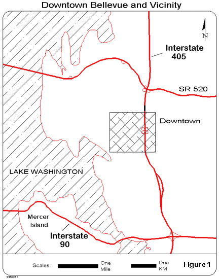
As shown in Figure 1 , it is bounded by freeways on three sides and Lake Washington on the other. It covers an area of 1.7 square miles and is not currently very densely developed in that many of its buildings are single story structures surrounded by parking lots. Figure 2 is a map of the downtown that shows some of its major features, particularly the Interstate 405 freeway that passes through its eastern side. An aerial photo of the same area is also provided.
Designing a Consumer-oriented PRT Network Using an Interactive-Graphic, Micro-scale Approach
Downtown Bellevue is used to illustrate how a computer-aided design (CAD) tool can be applied to design a PRT network that will be consumer-oriented to the greatest extent possible. A detailed description and application of this program, called Circulator-CAD , has been published previously [Schneider, 1992]. Since all access to a PRT system has to be made by walking to/from PRT stations, this approach views the determination of the number and locations of the PRT stations as being of paramount importance. Essentially, this means that the stations should be located as close as possible to the people who are likely to use them. And, the number of stations should be large enough to provide a large proportion of the people with as short a walk (i.e. around 5 minutes or less) as possible.
As with any computer-aided transit planning study, the biggest task is the development of a database that can be used to support a computer-aided, interactive-graphic planning process. In the case of a PRT network design study, a micro-scale database needs to be developed that can be used to represent the characteristics of pedestrian walk trips as well as the more traditional street network and the traffic signal system that controls the movement of both autos and pedestrians at street intersections.
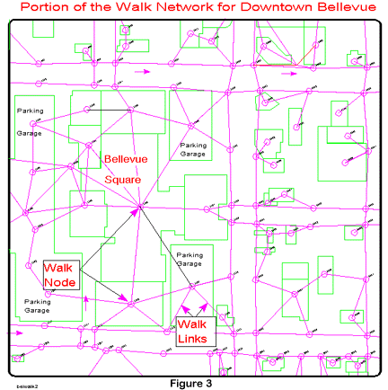
The first element of this database consists of two networks that were coded for use in subsequent analyses. Each network consists of a set of links (paths) and nodes (locations). The links are given a distance, travel speed and travel time. The nodes represent intersections of streets and other locations such as the lobby of a building or the edge of a sidewalk that defines a street crossing. The pedestrian walk network describes the pedestrian walk paths that are available and the delays (usually 1-2 or more minutes) that pedestrians encounter when trying to cross a street or some other barrier to walking .
Figure 3 is an illustration of a portion of the walk network used in this study. It could be even more detailed but at this level does provide a reasonable representation of the walk paths that are available to pedestrians in the downtown. In most cases, a building is represented by a single point and walk links to and from the building are represented as straight lines to adjacent sidewalks. Vertical movement within buildings is not explicitly coded in this study but could be represented by assigning a slower speed to a link to account for the time needed to use an elevator in a high-rise building. A more detailed walk network would probably yield longer walk times than those calculated in this study. It would include more nodes and fewer direct walk paths -- which usually don't exist in an actual urban walking environment.
Another important data element, embedded in both the auto and pedestrian networks, is a set of locationally-specific delays that account for the waiting times that both autos and pedestrians encounter at signalized intersections. In a downtown area like Bellevue, both autos and pedestrians often have to wait 1-2 or more minutes at such intersections. Values for these delays can be derived from data on traffic signal system timing so they can be included in the calculation of walk times on the pedestrian network. These delay times become important components of walk times along paths that are typically 3-10 minutes in length. To be precise, such times should actually be called walk-wait times.
A third network is eventually designed that defines the PRT guideway alignment (which is usually placed adjacent to existing streets -- although it can also be placed in other locations). In the approach used in this paper, this network alignment is not designed until a preferred set of station locations has been identified. Once this has been done, the PRT alignment is determined by connecting the preferred station locations in an effective manner.
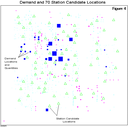
A second database element is the description of the locations of potential riders of the PRT system. Ideally, a full-fledged demand study is conducted to identify the locations and numbers of people who are potential customers. The result is a list of locations (nodes) with the number of people at each who will need to walk to the nearest PRT station to gain access to the system. In this example, a demand study was not conducted but a careful examination of available data on floorspace and other information was used to create this database element. It is an approximate representation of the spatial distribution of demand (numbers of people) in the downtown Bellevue study area. A display (map) of this demand database is shown as Figure 4 .
A third database element describes the set of all desirable and feasible PRT station candidate locations. Ideally, these data would be derived from a number of sources and checked-out with field inspections and conversations with property owners and others who are intimately familiar with the area. In this study, 70 such locations were identified using the author's knowledge and that of others who are very familiar with the study area and its potential for further development. These 70 station candidate locations are shown as triangles in Figure 4 .
The characteristics of the micro-scale downtown Bellevue database that was coded for this study are as follows:
- Number of network nodes (both auto and pedestrian networks): 1,116
- Number of network links (both auto and pedestrian networks): 5,098
- Number of demand locations: 555
- Number of candidate locations for PRT stations: 70
- Number of network nodes that have a walk delay penalty: 410
- Mean nodal demand: 103 persons
- Demand range among the demand nodes: 2 to 1882 persons
Setting Network Design Objectives
In addition to developing the micro-scale database, the planner has to devise a set of performance objectives for the PRT system. This should be done in close consultation with the stakeholders (clients) of the area so that there is general agreement as to what level of system performance should be sought. Walking is viewed as being the most onerous part of a PRT trip. Once a person is seated in a moving vehicle, travel times become much less important.
Since this is a consumer-oriented approach, a primary objective would be the number of people who have origins within X minutes of walking time to the nearest PRT station. For example, it might be decided that the system should be designed so that 75% of the people can reach a station with a walk of 5 minutes or less, 90% with a walk of 10 minutes or less and 100% with a walk of 15 minutes or less. These figures can be interpreted as representing the "coverage" provided by the system. These values are determined mainly by how many stations are provided and where these stations are located.
These coverage values would be set to reflect the desires of the clients who would be able to take many local factors (e.g. rain frequency, hills, lack of sidewalks, etc.) into account in making this judgment. Many other design objectives can also be defined. Examples are 1) the areawide average length, in minutes, of a walk trip to a PRT station, both areawide and station-specific, 2) the expected loading of each station in the system and the areawide average of station loading -- as well as several others. To keep this example simple and clear, only the coverage measures mentioned above will be used.
For our purposes, suppose that the initial coverage objectives are set as follows: 85% within 5 minutes, 95% within 10 minutes and 100% within 15 minutes of walk time. Simply stated, we want the planner to first determine how many stations, in which locations, would satisfy this coverage objective. Since there are 70 station candidates, the task becomes one of determining the smallest subset of these 70 locations that can satisfy the specified coverage objective.
Searching for the Preferred Number and Locations of the PRT Stations
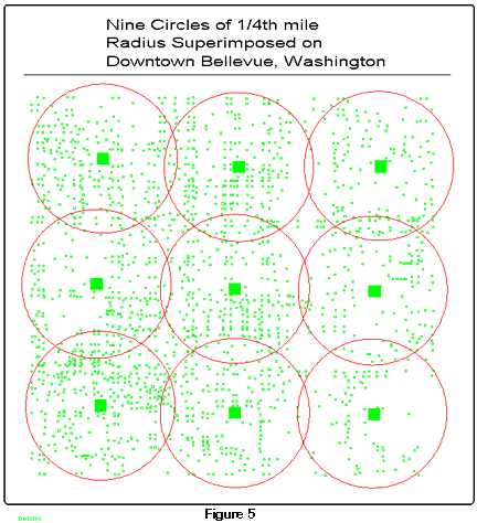
It is normally useful to try to find some upper and lower bounds for a problem of this type so that the search effort required can be minimized. As a lower bound, one can use the conventional approach that says that one needs to have at least one PRT station every half-mile so that no one has to walk more than a quarter-mile to a PRT station. This rule-of-thumb assumes that the demand is uniformly distributed and that walking in any and all directions is equally easy and fast - which, of course, it is not. As shown in Figure 5 , applying this rule to downtown Bellevue results in nine stations located about 1/2 mile apart. When the coverage measures for these nine stations is calculated, they show percentages of 30%, 62%, and 89% for the 5, 10 and 15 minute walk time intervals. Since these values are clearly insufficient relative to our objectives, this result tells us that we definitely need more than 9 stations.
Common sense tells us that we are not likely to need 70 stations to serve this small area. Instead, the planner's judgment can be used to estimate the minimum number of stations most likely to achieve the coverage objectives. Clearly, this is going to be an iterative (trial and error) process, the length and difficulty of which will depend on the planner's skill and soundness of judgment. All the planner has to do is to select the number of stations to be examined. Once that is done, the problem is turned over to a computer program that will conduct a search for the "best" locations for that given number of stations.
This search program, called OPTIMAL, can be used to conduct a heuristic search for (X) station locations that will be as close as possible to the people who must walk to them. It uses a "steepest descent" search algorithm and the computation typically takes only a few minutes with a reasonably powerful personal computer. It "finds" a set of locations that are as close as possible to the distributed demand in the downtown. A subsequent calculation is then made to determine the level of coverage that this set of stations provides. In this example, it was decided to make the first search with this program using just 18 stations. The OPTIMAL program was run three times and the best result was retained. In this application, it generated and evaluated about 2,500 different 18-station location patterns before it could find no further improvement and stopped searching. The coverage result obtained for the five minute time interval was 63.2%, still well short of the desired level of 85%. Next, a second search was performed using 25 stations and the 5-minute coverage result rose to 81.5%, close to the 85% objective but not yet sufficient.
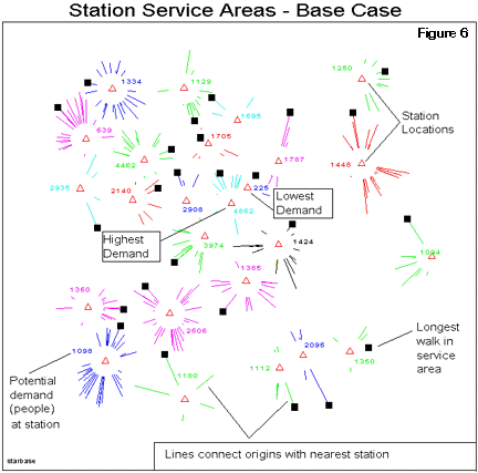
Several displays (maps) are available that can assist the planner see other aspects of the quality of this 25-station result. Figure 6 shows the service areas for each station in this 25-station design. Also shown are the numbers of people in each service area and the longest walk trip in each service area. The station load figures (number of people) in each service area ranges from a low of 225 to a high of 4,862. High demand is not usually a problem as a PRT station can have as many berths as needed to accommodate it. Low demand is a problem as each station must have enough potential demand to justify its inclusion in the design. Figure 7 shows those locations (color coded on the monitor screen) that are "uncovered". This means that a person originating at these locations will have to walk more than 15 minutes to reach the nearest PRT station. This map can serve as a guide to the planner in locating and making design modifications that will produce improved coverage performance.
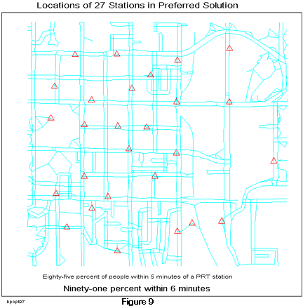
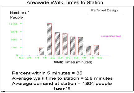
The next step in the network design process is to find one or more ways to improve the system's coverage performance. While there is no single way of doing this, the planner will usually make use of the "uncovered" map to identify some design modifications that are likely to be productive. The uncovered demand locations are color coded to show which are relatively closer or further away from a station. Using this map ( see Figure 8 ), it was decided to add another station in an area with low coverage as is shown in Figure 8 (Mod. #1). This raised the 5 minute proportion to 83.6% which is a modest improvement in the right direction. Next, a station was moved from a low demand location to an area with poor coverage as shown in Figure 8 (Mod. #2). The result was an further improvement to 84.7%. Then, another station was added to an area with poor coverage (Mod. #3) and the 5 minute value obtained was 85% -- which satisfies the 5 minute walk-wait time coverage objective (as well as the 10 and 15 minute walk time objectives). Figure 9 is a map that shows the locations of the 27 stations in the preferred design. Another aspatial display of the areawide performance of this design is shown in Figure 10 . It is a bar chart that shows the number of people in relation to their walk times to the nearest PRT station. It also shows that the areawide average walk time is 2.8 minutes and that there is an areawide average of 1804 people in each station service area.
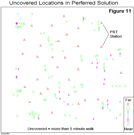
If an even higher level of performance were desired, a map ( see Figure 11 ) of all locations that have walk times greater than 5 minutes can be generated and used to help the planner find other station plan modifications that will generate higher coverage values. But, for our purposes, we will stop here and refer to the 27-station design as a first step toward the achievement of a preferred PRT network design.
Other tests of this preliminary design can be made. For example, the walk time intervals can be changed to probe other time intervals of interest. When we changed the time intervals to 2, 4 and 6 minutes and recalculated performance, it was found that the coverage measure for a 6 minute or less walk time was 91.5%. For a walk of 7 minutes or less, the coverage value was 96.3%. These values are certainly as high as one could hope for in a downtown area like Bellevue that features several superblocks and major steet intersections which together make walking somewhat difficult.
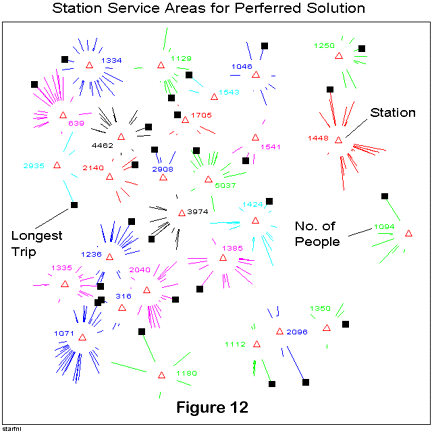
Other analyses of the performance characteristics of the candidate design can be obtained if desired. For example, Figure 12 shows the service areas of each station and the total number of people located in these service areas. These service areas are calculated based on the assumption that each person knows where the nearest PRT station is and will prefer to walk to it instead of a more distant station. The total number of people in a service area gives the analyst some idea of the likely loading of the station which is a guide to determining how many berths it should have. It is not necessary to try to have an equal level of loading at each station but it is desirable that each station have enough potential patrons in its service area to justify its existence. In the preferred design, one station has a service area population of only 316 and another has only 639. In an actual study, some further analysis would be made to see if dropping or moving these two stations could produce a better or comparable coverage result and a better (higher average) station loading -- for less capital cost.
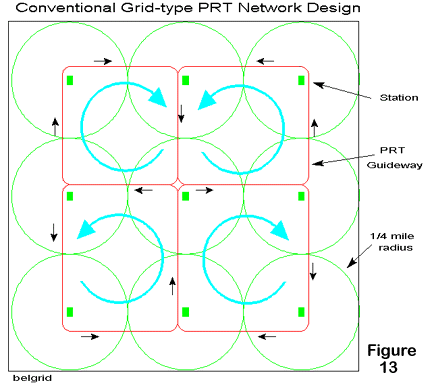
Once a satisfactory set of stations locations has been determined, the planner must next determine how to connect them with one-way guideway so that a full PRT network is defined. While some work has been done on developing a computer program [Schneider and Ma, 1991] that can do this automatically and optimally, it is not yet capable of solving a problem of the size defined in this illustrative example. The computational complexity is just too great. But, intuitive methods can be used by a planner who is thoroughly familiar with the study area. Figure 13 is an illustration of the conventional approach to the design of a guideway alignment. Adjacent stations are connected with one-way loops and the direction of travel in these loops is alternatively clockwise or counter-clockwise.
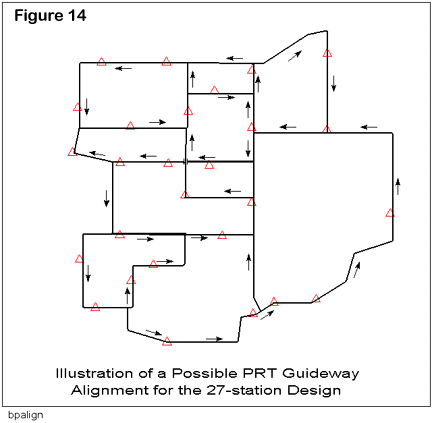
Using a similar approach, Figure 14 shows one (of several) possible PRT guideway layouts that connects all 27 stations in a reasonably coherent configuration. If origin/destination data are available, they can be used to assist the guideway alignment design process by making sure that the major O/D flows are connected as directly as possible. In this process, some station locations may have to be adjusted and the performance of the system relative to its closeness to its customers recomputed. Normally, some reduction in performance may result from such adjustments but it is also possible that some improvements may be achieved.
When the guideway alignments have been determined, the network can be used to perform a variety of operational simulations that will determine if it is capable of being operated in an effective manner under a selected set of different loading conditions. This simulation network would also have to include at least one storage facility for empty vehicles. Locating such storage depots is a problem that is similar in some ways to the station location problem. They need to be placed so that the travel of empty vehicles is minimized as well as serving many other objectives and constraints. This problem has been explored in some detail in a PRT network planning study in Gothenburg, Sweden (Andreasson, 1994).
As it true at any step of this design process, the simulation results may show the need for design modifications in the station numbers and locations or in the way that the stations are connected (i.e. the guideway alignment). Such adjustments are easily made when the entire design process is computer-aided. This allows database and design element changes to be made and performance measures recomputed quickly and easily and will help to insure that they remain high enough to be acceptable to the clients.
Discussion
The main finding of this study is that the conventional PRT network planning approach to locating stations in a grid pattern, approximately one-half mile apart, is not likely to produce satisfactory performance results for a consumer-oriented PRT system. Use of the conventional approach would suggest that 9 stations are sufficient while our analysis finds that something like 27 stations would be needed to meet a high, but reasonable, walk time performance objective. PRT planners must give prominent recognition to the fact that access to the PRT system will be made solely by walking to the nearest station. This means that careful attention must be given to the micro-scale coding and analyses of these walk trip times.
Our findings suggest that a study of the walking behavior of the people in the study area should be conducted early in the planning process. Results from such a study can help determine what an appropriate walk-wait time objective would be for a particular PRT network design study. Walking is not an activity that many people enjoy, especially after a hard day at work or when the weather is too hot or cold or when it is raining or snowing. Moreover, some people find auto noise and tailpipe emissions to be quite objectionable and a significant deterrent to walking.
The use of focus groups can probably help the planner determine what level of coverage performance is needed in a particular application. Ignoring this task and setting an inappropriate coverage standard is likely to have adverse effects on realized patronage once a system is up and operating. It is recommended that walk-wait times to and from PRT stations be minimized and this probably means that more stations must be provided than the conventional, PRT provider-driven, planning approach would suggest.
Provision of more stations has both capital cost and operating implications that are likely to be severely underestimated using conventional planning methods. For example, more stations will require more off-line guideway. Currently, it is estimated that the length of off-line guideway will be about 15% of the length of mainline guideway. Using this rule-of-thumb, one would need about 7.5 miles of off-line guideway to support a network consisting of 50 miles of mainline guideway. It seems likely that this figure might have to be raised if a consumer-oriented approach that stresses the need to minimize walking-waiting times to/from to a somewhat larger number of PRT stations is used.
In addition, it is possible that more mainline guideway will be needed to connect a larger number of stations and that more of this guideway will consist of curved (more costly) guideway segments and that it will be harder to avoid costly guideway intersections that involve under- or overpasses and turning ramps.
It has been found that the computer programs used offer good support to the planner who wishes to iteratively improve a design by making a series of incremental design modifications. The graphic displays provided offer many visual clues as to where weaknesses in a particular design exist and allow the planner to rapidly define ways to add, delete or move stations so as to improve performance. These modifications can be evaluated almost immediately. Those that show no improvement can be discarded quickly, allowing an almost immediate search for a better solution to be implemented. A design process that has often taken months to conclude can be performed in a few days at best with this kind of computer-aided design tool.
While not a part of this illustrative example, it should also be recognized that determining the location and number of stations in an actual study is likely to involve some, perhaps intense, local politics. If the local property-owners perceive that having a station on their property is of benefit, then they may campaign actively for a station - even if they have to provide a share of its cost. They may also try their best to make sure that their main competitors do not get a station. Of course, the opposite may be true if some or all of the property-owners perceive having a PRT station as a negative development (e.g. visual intrusion, people parking at their site in order to take a "recreational ride", the station as an attractive nuisance) and campaign actively to insure that they do not have one located on or near their property. The point is that as the study progresses, several changes (additions, deletions, moves) in station locations may have to be made to accommodate, to the extent possible, the wishes of the people who own the station candidate sites. Given such dynamics, a computer-aided design tool becomes particularly necessary so that such changes and adjustments can be made and evaluated quickly and effectively as they arise.
References
Andréasson, Ingmar, 1994, Vehicle Distribution in Large PRT Systems, Transportation Research Record, No. 1451, Transportation Research Board: Washington, D.C., pp 95-99.
Garreau, Joel, 1991, Edge City: Life on the New Frontier, Doubleday: New York
Hooper, Kevin, 1989, Travel Characteristics at Large-Scale Suburban Activity Centers, NCHRP Report 323, Transportation Research Board: Washington, D.C., 106 pp.
Kulash, Walter, Michael Brown and Frances Chandler, 1989, Peoplemovers in High Activity Centers in Proceedings, Automated Peoplemovers II, edited by M.V.A. Bondada, W.J. Sproule and E.S. Neumann, American Society of Civil Engineers: New York, New York, 808-818.
Schneider, J.B., 1981, Transit and the Polycentric City, Final Report, DOT-1-81-33, U.S. Department of Transportation, Urban Mass Transportation Administration: Washington, D.C. 294 pp
Schneider, J.B. and Jun Ma, 1991, Designing Personal Rapid Transit (PRT) Networks, Journal of Advanced Transportation, 25:3, pp 247-268
Schneider, J.B., 1992, A PRT Deployment Strategy to Support Regional Land Use and Rail Transit Objectives, Transportation Quarterly, 46:1, 135-153.
Schneider, J.B., 1993, Designing APM Circulator Systems for Major Activity Centers : An Interactive Graphic Approach, in Proceedings, Automated Peoplemovers IV: Enhancing Values in Major Activity Centers, edited by W.J. Sproul, E.S. Neumann and M.V.A. Bondada, American Society of Civil Engineers: New York, N.Y., 535-545
Stuart, Darwin, 1979, Internal Circulation within Major Activity Centers: Issues and Problems, Transportation Research Record, No. 1046, Transportation Research Board: Washington, D.C., pp 84-91.
Posted: August 24, 1997; last modified: March 15, 2010