Creation of a Native Shrub Buffer and Enhancement of a Wetland
in the Union Bay Natural Area
Group 5 Project Team
EHUF 473
Winter Quarter, 2001
University of Washington
Raymond J. Larson · Flora
Nisanova · Kerri Omaits · Josh
Reinertson · Nicol Whitney
“So many old guests have gone, so many new ones have appeared, so much activity is displayed by the visitors that I feel that I am looking, not at a static home for a few permanent residents but a place which furnishes food and shelter to numerous transients.”
Hingman and Larrison, Union Bay (1951).
“‘Success’
is rarely total in science. Try to
see the forest for the trees.”
Oliver Wendell Jones, Bloom County (1985)
Introduction
The discipline of restoration ecology involves managing communities that have been damaged by pollution or degradation (Townsend et al. 2000). Sometimes it is impossible to recreate what has been destroyed, but it is possible to revegetate open scars and reintroduce native species (Bradshaw 1984).
 During
the winter quarter of 2001, restoration work on a cleared part of the Union
Bay Natural Area (UBNA) has been undertaken as part of the Kern Ewing’s EHUF
473 class curriculum. The UBNA consists
of 60 acres adjacent to the highly developed lands of the University of Washington
campus, and provides habitat for a wide variety of plants and animals.
During
the winter quarter of 2001, restoration work on a cleared part of the Union
Bay Natural Area (UBNA) has been undertaken as part of the Kern Ewing’s EHUF
473 class curriculum. The UBNA consists
of 60 acres adjacent to the highly developed lands of the University of Washington
campus, and provides habitat for a wide variety of plants and animals.
The UBNA is the site of a former landfill, which itself rests on a deep peat deposit on the shores of Lake Washington. The site at present has extremely poor soils, largely consisting of an impermeable clay layer that covers the landfill. The soils are saturated in the wetter months and extremely dry during the summer months due to seasonal variances in precipitation and lake levels. The soils are, therefore, low in productivity and prone to drought (Dunn and Ewing, 1997).
As an open space, this area provides wildlife habitat, a diversity of herbaceous and woody plants, and views to the lake for local residents. In addition, a highly used trail, Wahkiakum Lane, bisects the site, and together with other smaller trails, is used by pedestrians, joggers, bicyclists, and wildlife enthusiasts.
It is also a scientific research area, and the land provides an opportunity to study aspects of biodiversity in an urban environment. Union Bay is home to over 184 species of birds and more than 150 species of plants (Seattle Times, 1991). Numerous small scale projects have been undertaken over the last fifteen years in an attempt to restore aspects of the site to a more natural, diverse, and functional ecosystem.. These efforts have met with both success and failure, and new techniques are continuing to be studied in an effort to more successfully restore the site. They include restoring native plants, eliminating invasive species, managing plant communities, reducing air pollution, noise, reestablishing drainage, and increasing productivity of the soil (Dunn 1966).
The principle goal of this project was to establish both a functioning ecosystem of native shrubs and perennials in an upland portion of the UBNA, and to increase native plant establishment in an adjacent seasonal wetland. The project site chosen for this effort is directly to the east of the prairie restoration project bordering UW parking lot E-5.
Several treatments were proposed for the upland restoration site, involving questions of weed control and establishment techniques. There were also treatments for prairie mounds that were added in the transition zone on the edge of the existing prairie and the upland portion of our site. These will be discussed in the methods section.
Group 5 Project Team
Ray Larson is a Masters of Science candidate in the Urban Horticulture program at the
Center for Urban Horticulture, in the College of Forest Resources.
Flora Nisanova is an undergraduate Biology major in the College of Arts and Sciences.
Kerri Omaits is an undergraduate Wildlife Science major in the College of Forest Resources
Josh Reinertson is an undergraduate Environmental Horticulture and Urban Forestry major
in the College of Forest Resources, and a Landscape Architecture major in the
College of Architecture and Urban Planning.
Nicol Whitney is a Masters of Science candidate in the Forest Soils program in the
College of Forest Resources.
Site
History
The site of our project is adjacent to the area of previous prairie restoration projects, directly to the east of parking lot E-5. The site is part of the UBNA, and is managed by the Center for Urban Horticulture (CUH). The UBNA has a complex and varied history, and human activity over the last 100 years has dramatically altered the site from its original, pre-settlement condition.
Prior to the lowering of Lake Washington in 1916, this entire area was under water. Our project site lies over one of the deepest peat deposits in the state. The nearly 120 feet deep deposit was formed over many centuries of accumulation of organic plant matter and sediments where the outflow of Ravenna Creek joined Union Bay. The lake levels fluctuated seasonally by as much as 7 feet annually, due to spring runoff from the surrounding watershed and fall and winter rains (Chrzastowski, 1983). The construction of the Lake Washington Ship Canal resulted in a drop in the lake level by roughly 9 feet. This resulted in the creation of a large, shallow marsh reaching from what is now NE 45th St. south until what is now the southern shoreline of the UBNA.
The University of Washington, which had title to most of the newly created land south of NE 45th St. and west of what is now Mary Gates Memorial Drive, began land-filling operations in 1926 (Jones and Jones, 1976). The City of Seattle also used this area as a landfill beginning in 1930. For most of the 1930s, the fill was concentrated toward the northeast corner of the area, near the intersection of NE 45th St. and Mary Gates Memorial Drive. Fill operations increased throughout the subsequent decades, eventually covering almost the entire area of what is now the UBNA by the early 1960s. The area of our project site was part of the ‘sanitary’ fill operation (primarily layers of garbage and soil) that finally ceased operations in 1966 (Shannon and Wilson, 1966). The landfill was capped with a layer of clay after the site was closed, and soil from the construction at the UW’s Health Sciences Center was added to the area in 1971. Contract specifications for closing the landfill stipulated the addition of 6 inches of sandy loam topsoil over the entire site, which was nearly 200 acres at the time (Bishop and Turnberg, 1984). However from our studies this seems to not have been carried out with any degree of uniformity, as we found no evidence of any topsoil over 1 inch deep on our portion of the site. After whatever topsoil was added in 1971, the landfill was seeded with a variety of non-native pasture grasses.
The weight of the landfill and the continued decomposition of the underlying peat has resulted in substantial settling of the land over the years. Several large ponds have formed in depressions on the surface of the landscape, and the area has a gently undulating appearance. It is expected that this area will continue to settle with time and that much of the lower areas will eventually become part of Lake Washington (Jones and Jones, 1976).
Since 1971, a variety of plant species have colonized the area. A variety of grasses, forbs, shrubs and trees now cover the landscape. However, the thin, poor soils of the UBNA have resulted in few trees of any size. A variety of native and non-native species moved in quickly, and changed the nature of the vegetation on the site. What was once primarily grassland eventually became an increasing thick patchwork of Himalayan blackberry thickets and other invasive plant species.
In the 1980s, CUH began to manage the site for the University of Washington. A management plan was developed for the UBNA in 1995, and work has progressed toward the removal of invasive species and the restoration of the site to a mix of native plant habitats.
Since 1997, Professor Kern Ewing’s Restoration Ecology class has worked on the area immediately east of the E-5 parking lot. For the first three years, class groups worked on the restoration of the eastern part of the parking lot. These efforts resulted in the creation of a prairie ecosystem, modeled on the historical prairie landscapes of the south Puget Sound region.
Beginning in 2001, attention turned toward the restoration of the area immediately to the east of the prairie. As this landscape is in more of an upland area, with less gravelly soils, it was decided to plant the site with a mixture of native shrubs and trees so that a buffer between the prairie and the rest of the UBNA could be established. It is hoped that this buffer, once established, will help reduce the spread of windborne invasive plant seeds into the recently created prairie. It is also hoped that these new plantings will hinder the re-establishment of invasive plant species.
Assessment of
the previous year’s prairie restoration projects
Both reports of the EHUF year 2000 groups, the Alpha group and Epsilon group, attempted a variety of treatments in the prairie sites directly to the west of our project area (Alfano, et al, 2000 and Bennett, et al, 2000). Most were well laid out, and some of the Epsilon groups were rather ambitious (see project reports at http://faculty.washington.edu/kern/uhf473/hmpg473.htm.) Both the Alpha and Epsilon groups used appropriate plant material for the sites in question. Density was sparse in some areas, but the groups explained this. Some treatments sought to compare planting densities and methods, and mortality was expected in some portions of the site. Execution was lacking in a few of the treatments, but most were well thought out and implemented. Not all of the treatments were successful, but this was the point of the studies—to determine more effective restoration strategies.
The
composition of the old site is quite varied due to the differing types of
treatments used. In the Alpha portion
of the site, roughly 75% of the site bordering the western side of our new
plot, all of the mounds had similar success in establishment across the treatments.
The mounds protected from herbivory by enclosures appeared as successful
as those without protections. An equal
number of the mounds had been effected by herbivory, disturbance, or mulching
treatments. Some mounds were lush
and healthy looking and some were sparser in appearance. Some mounds had a higher composition of natives than others, but
the enclosure treatments did not show a detectable difference. It was impossible to detect the survivability
of the Camassia quamash (common camas) that had been planted, as they
were still dormant during the winter. The westernmost (wetland) portion of the site
showed only marginal success in establishment of woody species. Only 3 of the original 16 Cornus stolonifera
(red-twig dogwood) plants were visible above the waterline, though there
were numerous willows and alders present. Weeds encroached upon the mounds at densities
ranging from 10-50%. The intermound
area had weeds over 10-20% of the site, with the rest of the area being bare
soil or sparse native grasses. In
the wetland portion of the site, no weeds were observed.
In the Epsilon portion of the site, the other 25% percent of the site bordering our new plot, none of the planted Eriophyllum lanatum (woolly sunflower) or Camassia quamash (common camas) was visible, though the Festuca idahoensis (Idaho fescue) was present and healthy. The wetland portion of their site showed some successful willow plantings, as well as a few alder and red-twig dogwood plantings. The Quercus garryana (Garry oak) did not survive the summer, perhaps due to trampling by humans or lack of water. Weeds were not extensive, covering no more than 10% of any treatment zone. This was also true in their portion of the wetland area.
The seeding of the Idaho fescue was somewhat successful on both of the sites and was approximately the same for all treatments. Fifty to ninety percent of the containerized plants that were still visible above ground (not deciduous or dormant) seem to have survived, with the highest success rate being found in the Idaho fescue, at approximately 90%.
The level of flooding in the sites that we observed seems to roughly approximate the indicated levels from last year. The boundary of the wetland could be moved eastward slightly, but recruitment from the wetland plantings after establishment may take care of this.
 In
the Alpha section of the site, all constructed features seem to have survived.
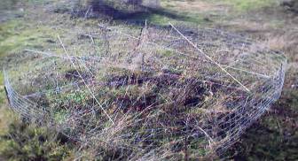
The mounds are intact. The herbivory prevention enclosures are intact,
however, their level of functioning is debatable. The enclosures are rather low at ~2 feet in
height, and it is questionable whether the achieved any real deterrence. The cages containing the organic matter in
the wetland portion seem to have lost all organic matter (perhaps due to the
rather large openings in the chicken wire) and it is difficult to assess the
effectiveness of this treatment (some of the plants within have survived,
but it did not seem to prevent the loss of organic matter).
In
the Alpha section of the site, all constructed features seem to have survived.
The mounds are intact. The herbivory prevention enclosures are intact,
however, their level of functioning is debatable. The enclosures are rather low at ~2 feet in
height, and it is questionable whether the achieved any real deterrence. The cages containing the organic matter in
the wetland portion seem to have lost all organic matter (perhaps due to the
rather large openings in the chicken wire) and it is difficult to assess the
effectiveness of this treatment (some of the plants within have survived,
but it did not seem to prevent the loss of organic matter).
In the Epsilon section, the constructed features survived. The mounds are still intact and functioning. The ditch that was dug to control the spread of the pasture grasses seems to have worked well. The other constructed features had no effect, as they were not designed for purposes other than simple delineation of plots.
Herbivory at the site is a problem, though geese populations seem to have decreased from previous years. Survival of planted species would likely have been greater if efforts to control herbivory had been more effective. However, the presence of herbivory was noted as being rather low, at least during this time of year.
Recommendations
for continued maintenance and monitoring of the old sites
Some of the larger weeds were manually removed by hand. Weeding in this area seems to have occurred since last year’s group completed their work, as the overall level of weeds was quite low, and invasives were largely absent from at least this part of the prairie.
Plants introduced during previous restoration efforts seem to be establishing and spreading, though at a slow rate. Idaho fescue (Festuca idahoensis) and wild strawberry (Fragraria virginiana) seem to be doing quite well. Therefore we decided to leave these sits largely alone for this year’s project.
Soils Found at
the Site
Earlier groups working on the restoration of the prairie portion of the site had much different soil conditions to work with than those found on our portion of the site. As lot E-5 was for many years a gravel parking lot, and received regular additions of gravel to maintain the grade, these soils were deemed suitable for prairie plant introductions. The model system for these earlier restoration efforts were the prairies of the south Puget Sound region, which are generally full of coarse materials such as gravel, and typically have well-drained soils. The Puget Sound lowland prairie formations were originally influenced by the geologic history of glaciation in the Puget Sound region. Glaciation resulted in coarse-textured and fairly excessively drained outwash deposits, which combined with a warmer period following glacier retreat to create a habitat for prairie ecosystems. Even with climate changes toward the present trend of cooler and moister conditions, prairie systems remained in place both because of burning practices by Native Americans and significant ground cover by prairie vegetation that discouraged establishment of seedlings from nearby forests (Zabowski, 2001).
Soils of the Puget Sound prairies are often within the Spanaway Soil Series. The National Cooperative Soil Survey describes the horizons making up the Spanaway as a black gravelly sandy loam A horizon, dark yellowish brown gravelly sandy loam B horizon, and dark yellowish brown gravelly sand C horizon. These horizons differ somewhat in mounded prairie systems of the Spanaway series. Mounds may be from 8-70 feet in diameter and 1-7 feet high (Zabowski, 2001). The A horizon may extend as deep as seven feet thick in portions of a prairie mound, in contrast to several inches in intermound areas.
Contrasting Spanaway
soils with the soil conditions at our site
In our project site, approximately the first six inches of soil within
several feet from the western end of the plot is dark brown gravelly loam,
with an abrupt wavy boundary of gravelly clay fill.
Soil through the rest of the plot appears to be significantly gleyed
 clay
with an A horizon that is often negligible or non-existent.
clay
with an A horizon that is often negligible or non-existent.
The use of swelling-type clays on the area of this plot is to be expected considering its history as a landfill, as clays are useful in preventing the movement of water into and out of a contaminated system (Brady and Weil, 1999). It is not, however, an ideal planting substrate as its higher bulk density may inhibit root penetration. The ability of water to move through clays could also prove to be discouraging for the establishment of vegetation, as water infiltration and movement is slow when the soil is dry, and can tend toward saturation in a wet environment such as Puget Sound.
Methods and Materials
Our project group was assigned
an upland portion of the Union Bay Natural Area, which also encompassed a
small wetland. Using a variety of
native shrubs, perennials, bulbs and trees, we implemented a planting scheme
that will test several treatments for weed control and plant establishment.
Through research, assessment of site conditions, and the use of proper
horticultural practices, we created a landscape that will hopefully in time
result in a diverse and functioning ecosystem of native plants and organisms. It is also hoped that future groups will find value in the different
treatments that were undertaken, so that the best methods for establishing
native perennials and woody plants can be implemented for other restoration
projects in the Union Bay Natural Area. The treatments we used and the methods involved in implementing
them are 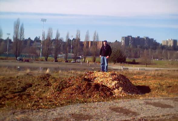 described
below.
described
below.
The shrub
buffer
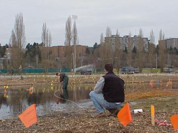
The upland portion of the site was covered with a large amount of mulch, ranging in depths from 1-3 feet. Additionally, there were two very large piles at the eastern edge of the site. Underneath the mulch, there was a matted layer of declining plant material, including pasture grasses and other weeds. The soil, which was described previously, consisted primarily of a very thin A layer overlaying a thick layer of clay fill of undetermined depth. The soils were saturated and reduced with no evidence of oxidation throughout the clay layer, and test holes revealed a high water table.
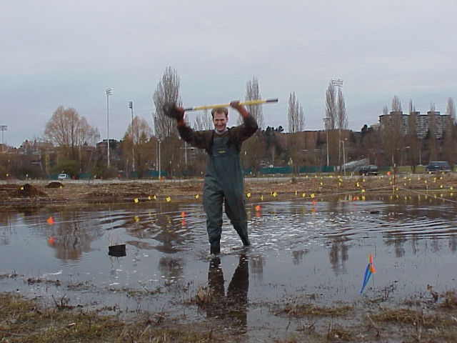
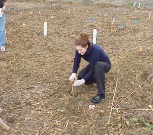
Ray surveys the site atop one of the piles of mulch that was later
removed from the project site
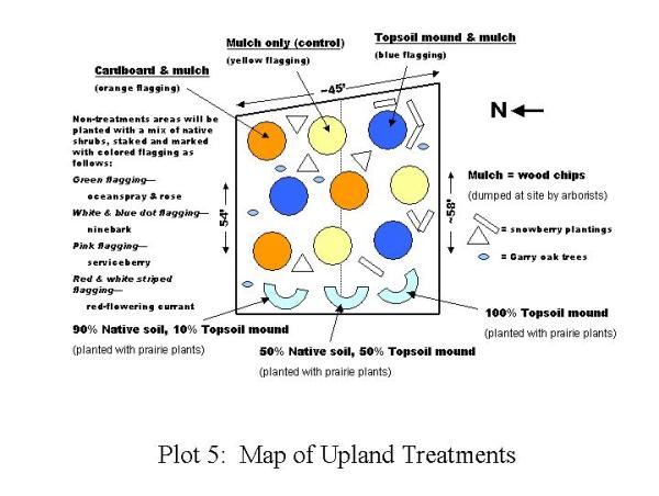
Treatment areas were plotted as follows: 9 circular treatment areas of 10 feet in diameter set between 4-5 feet apart, and 3 crescent shaped treatment areas of 8 feet across by 2.5 feet deep. We removed approximately 30 wheelbarrow loads of mulch to the designated wood chip dump zone. Treatment areas were completely excavated of mulch, which was dispersed to the inter-treatment areas.
 The nine circular areas were separated
into three different treatments. These
treatments were designed to test methods of weed suppression and plant establishment.
Each treatment was staggered to account for any differences in soils
or other conditions at the site. Treatments
were marked with colored flags that indicated the type of treatment. The first treatment (yellow flagging) consisted of shrubs planted
into the
The nine circular areas were separated
into three different treatments. These
treatments were designed to test methods of weed suppression and plant establishment.
Each treatment was staggered to account for any differences in soils
or other conditions at the site. Treatments
were marked with colored flags that indicated the type of treatment. The first treatment (yellow flagging) consisted of shrubs planted
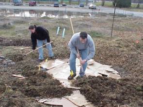
into the 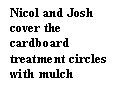 existing soil and covered with 6-8” of mulch. The second treatment (orange flagging) consisted of shrubs planted
into the existing soil which was then covered by layers of cardboard. Cardboard boxes were obtained and soaked in
the nearby wetland. The cardboard
was soaked in water so that it would not inhibit uptake of water and air by
the plants. Cardboard was then carefully
around the plants. The treatment circles
were then covered in 6-8” of mulch. The
third treatment (blue flagging) consisted of gradually sloping mounded topsoil.
Approximately 2 yards of sandy loam topsoil was obtained from the CUH
greenhouse and distributed evenly among the three treatments.
Shrubs were planted in the soil, and covered with 6-8” of mulch.
existing soil and covered with 6-8” of mulch. The second treatment (orange flagging) consisted of shrubs planted
into the existing soil which was then covered by layers of cardboard. Cardboard boxes were obtained and soaked in
the nearby wetland. The cardboard
was soaked in water so that it would not inhibit uptake of water and air by
the plants. Cardboard was then carefully
around the plants. The treatment circles
were then covered in 6-8” of mulch. The
third treatment (blue flagging) consisted of gradually sloping mounded topsoil.
Approximately 2 yards of sandy loam topsoil was obtained from the CUH
greenhouse and distributed evenly among the three treatments.
Shrubs were planted in the soil, and covered with 6-8” of mulch.
The following plants were used in the non-prairie portion of the upland site:
|
Shrub Buffer Vegetation |
||
Quantity |
Species
(Latin/Common) |
Stock
Unit |
|
200 |
Symphoricarpos
albus/snowberry |
bare root |
|
13 |
Physocarpus
capitatus/ninebark |
bare root |
|
12 |
|
1 gal container |
|
11 |
Ribes
sanguineum/red-flowering currant |
bare root |
|
11 |
Holodiscus
discolor/oceanspray |
bare root |
|
9 |
Rosa
pisocarpa/clustered wild rose |
bare root |
|
9 |
Philadelphis
lewisii/western mock orange |
bare root |
|
5 |
Quercus
garryana/garry oak |
1 gal container |
See
Appendix for plant descriptions
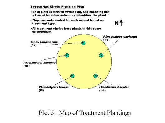
The plants used in the nine treatment circles were red-flowering currant, oceanspray, western ninebark, western mock orange, western serviceberry. One plant of each species was placed in each treatment circle. The planting pattern was uniform throughout the circle treatments. Each plant was marked with a colored flag and the flag was marked with a 2 letter abbreviation indicating the species planted.
The
areas between treatments were planted with a mix of native plants. Snowberries were planting in groups of 20-30,
from 8-12 inches apart. The group
working on the site to our north planted a high number of garry oaks, which
gave the site a dense, formal appearance. We decided to plant five garry oaks, primarily on the north part
of our plot to create a gradual transition to a more open landscape. We planted Rosa pisocarpa in small groups between the mounds. Finally, we planted the remaining shrubs that
were not used in the circular treatments between the circles in order to create
a more naturalistic appearance at the site.
The three crescent-shaped-mounded beds were set up
to test different soil treatments. Each
crescent was tilled with a roto-tiller to a depth of 6 inches. The northern mound consisted of 90% existing
soil and 10 % sandy loam topsoil. The
middle mound consisted of 50% existing and 50% topsoil. The southern mound consisted of 100% topsoil.
All three treatments were then roto-tilled to mix the soils and shaped
into crescents mounds for planting. The
purpose of these different treatments was to study the effects of varying
soil textures and quality on prairie plant establishment.
Crescents were constructed at the western side of our plot to create
a transition between the existing prairie and the shrub buffer. Five prairie species were planted:
|
Prairie Mound Vegetation |
||
Quantity |
Species (Latin/Common) |
Stock Unit |
|
32 |
Festuca
idahoensis/Idaho fescue |
1
gal container |
|
17 |
Balsamorhiza
deltoides/deltoid balsamroot |
4”
container |
|
14 |
Camassia
quamash/common camas |
4”
container |
|
10 |
Eriophyllum
lanatum/wooly sunflower |
4”
container |
|
8 |
Potentilla
gracilis/slender cinquefoil |
4”
container |
See Appendix for
plant descriptions
We distributed the plants between the
treatments in approximately equal amounts.
Plants were clustered in the same general location on each of the mounds
for ease of future identification and monitoring.
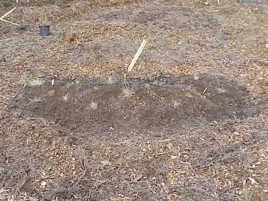
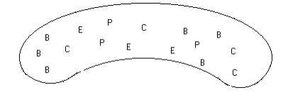
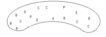
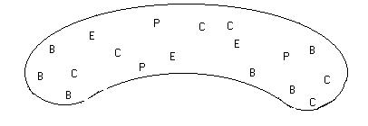
An example of the planting scheme on one of the prairie mounds
|
An example of the planting scheme on one of the prairie mounds |
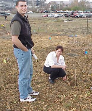
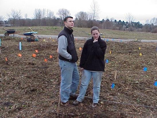
Flora marks a planting with a bamboo stake and flagging Kerri marks a red-flowering currant with a stake and ties red and
white striped flagging to it
Josh and Flora flag plants in the area between the circle treatments
The plantings in the treatments
are illustrated in the following diagrams:
|
Josh and Flora flag plants in the area between the circle treatments |
Plot 5: Map of Crescent Mound Plantings
(West End of Upland Treatments)
 Methods
used in restoring our portion of the wetland focused on creating a landscape
in which a variety of organisms could thrive.
Methods
used in restoring our portion of the wetland focused on creating a landscape
in which a variety of organisms could thrive.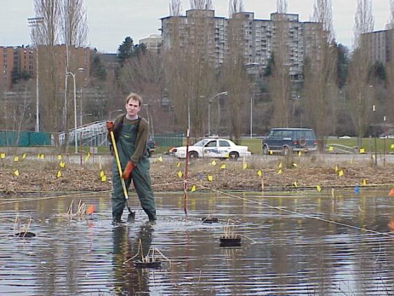 the
soft substrate.
the
soft substrate.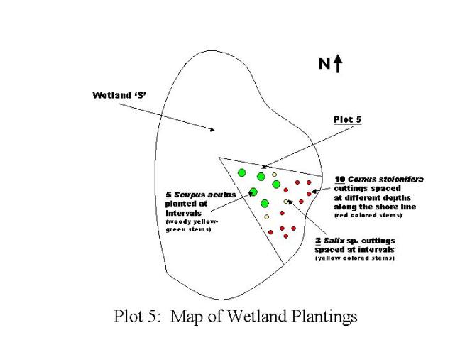
 work
with the soil conditions found at the project site.
work
with the soil conditions found at the project site.  Weeds can remain dormant when conditions are
unfavorable, only to germinate and produce healthy plants when conditions
have improved.
Weeds can remain dormant when conditions are
unfavorable, only to germinate and produce healthy plants when conditions
have improved.