Data from the Kauai ATOC Acoustic Source
Last updated November 23, 2005.
Data from ATOC are almost but not quite freely available for use. There are a number of peculiar issues
at the moment that prevent posting of these data here for ready download. Those interested in using
these data should contact Peter Worcester (pworcester@ucsd.edu) or Brian Dushaw (dushaw@apl.washington.edu). There
should be no problems obtaining the data; at the moment we merely want to keep track of who is using the data, and
maintain a dialog with users on how they are using and interpreting the data.
This past year (2005) there have been a number of problems with data collection associated with
the greater security restrictions. These restrictions have made remote monitoring of the health
of the collection system impossible, which has been the main issue (i.e., when the remote computers
crash for whatever reason, we are unaware.)
Comparison of Temperature with the ECCO model and TOPEX/POSEIDON Data
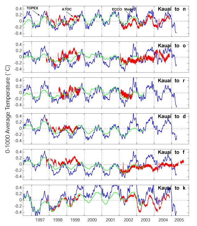
Time series of range- and depth-averaged temperature derived from the acoustic travel times (red, with
error bars) compared
to TOPEX/POSEIDON (blue) and ECCO model (green; JPL incarnation) data
(ECCO model link) averaged along the acoustic
paths. The
sea-surface height variations are assumed to be caused only by thermal expansion in upper 100 m;
the coefficient used to convert between temperature and sea-surface height is strongly temperature
dependent. In tropical regions, the ray sampling is subsurface, so the annual cycle of temperature is
sometimes not observed. Therefore, a better comparison to the ECCO model is made by calculating
the equivalent ray travel times in the ECCO model, shown below.
Comparison with the ECCO Ocean State Estimates
The analysis of path integral data is made much simpler by modern
ocean state estimation methods, using travel times as integral constraints
on the model variability. If the data estimated by the model do not match
the observations, then the ocean model state is adjusted to bring the model
into better agreement. As implemented by the ECCO Consortium (Estimating the
Circulation and Climate of the Ocean) and others (Stammer and Chassignet 2000,
Stammer, et al. 2001), state estimation also serves to best combine disparate
data types, which can then be evaluated for their contributions to reducing the
uncertainty of the solution. As a first step towards incorporating travel times
into the ECCO model cost function, ECCO model output was converted into travel
times for several source-receiver pairs. Different ray paths have different
sensitivities to the surface and to the deep ocean, and the estimation can
exploit this to obtain vertical information from a set of rays.
The ocean state estimate used here is based on an integration of the MIT General Circulation Model
in a global configuration that spans 75 S to 75 N, with latitudinal grid-spacing ranging from 1/3
degree at the equator to 1 degree at the poles and longitudinal grid spacing of 1 degree. The model
assimilates a variety of satellite and in-situ data and data products, including TOPEX/POSEIDON,
WOCE hydrography, XBT sections, etc. A description of this state estimate and the complete fields
are available at
http://eyre.jpl.nasa.gov/external/.
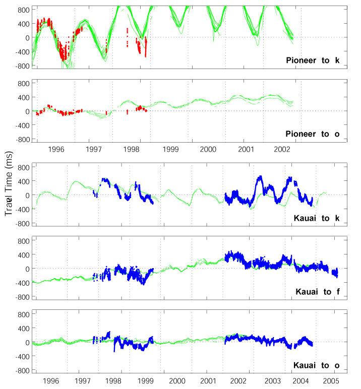
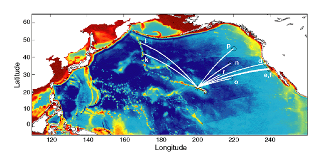
Travel time anomalies for the ATOC sources at Pioneer Seamount and Kauai transmitting to
receivers k, o, and f (red and blue lines, see the ATOC figure for receiver locations), compared with the
travel times calculated from the ECCO state estimates described above (green lines). Each
line represents a different ray path, which samples the ocean in a different way. A deeper
turning depth means the ray is sensitive to both the near surface and the deep ocean. Deep-turning,
surface-reflecting rays are less affected by the annual temperature cycle than rays
with shallow turning depths. The time series for sources or receivers near Hawaii have larger
variability because of the mesoscale variability near the Hawaiian Ridge.